Osredek pri Hubajnici
| Osredek pri Hubajnici | |
|---|---|
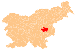
 Osredek pri Hubajnici Location in Slovenia | |
| Coordinates: 45°57′32.59″N 15°19′14.12″E / 45.9590528°N 15.3205889°ECoordinates: 45°57′32.59″N 15°19′14.12″E / 45.9590528°N 15.3205889°E | |
| Country |
|
| Traditional region | Lower Carniola |
| Statistical region | Lower Sava |
| Municipality | Sevnica |
| Area | |
| • Total | 0.94 km2 (0.36 sq mi) |
| Elevation | 407.3 m (1,336.3 ft) |
| Population (2002) | |
| • Total | 14 |
| [1] | |
Osredek pri Hubajnici (pronounced [ɔˈsɾeːdək pɾi xuˈbaːi̯nitsi]) is a small settlement southwest of Studenec in the Municipality of Sevnica in central Slovenia. The area is part of the historical region of Lower Carniola. The municipality is now included in the Lower Sava Statistical Region.[2]
Name
The name of the settlement was changed from Osredek to Osredek pri Hubajnici in 1953.[3]
Cultural heritage
An Early Iron Age burial ground with 37 burial mounds has been identified near the settlement.[4]
References
- ↑ Statistical Office of the Republic of Slovenia
- ↑ Sevnica municipal site
- ↑ Spremembe naselij 1948–95. 1996. Database. Ljubljana: Geografski inštitut ZRC SAZU, DZS.
- ↑ "EŠD 14744". Registry of Immovable Cultural Heritage (in Slovenian). Ministry of Culture of the Republic of Slovenia. Retrieved 17 October 2011.
External links
This article is issued from
Wikipedia.
The text is licensed under Creative Commons - Attribution - Sharealike.
Additional terms may apply for the media files.