Osam
| Osam | |
|---|---|
 | |
| Country | Bulgaria |
| Physical characteristics | |
| Main source |
Levski Peak 1,821 m (5,974 ft) 42°43′11″N 24°46′49″E / 42.71972°N 24.78028°E |
| River mouth |
Danube near Nikopol 40 m (130 ft) 43°42′7″N 24°51′10″E / 43.70194°N 24.85278°ECoordinates: 43°42′7″N 24°51′10″E / 43.70194°N 24.85278°E |
| Length | 204.6 km (127.1 mi)[1] |
| Discharge |
|
| Basin features | |
| Progression | Danube→ Black Sea |
| Basin size | 2,838 km2 (1,096 sq mi)[1] |

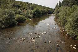
The Òsam (Bulgarian: Осъм) is a river in northern Bulgaria. Its drainage basin is in between that of the river Vit to the west and the Yantra system to the east.[2] The river has two main tributaries in its upper course: the Black Osam takes its source from the foot of Levski Peak in the Balkan Mountains, at an altitude of 1,821 m (5,974 ft), while the White Osam has its source on the northern slopes of the Kozya Stena peak. In Troyan, the black and white Osam join. It runs north towards Lovech, then north-east until Letnitsa and Levski, where it turns north-west until it flows into the river Danube 5 km west of the town of Nikopol. The ancient name of the river was Assamus.
References
- 1 2 Statistical Yearbook 2017, National Statistical Institute (Bulgaria), p. 17
- ↑ "Archived copy". Archived from the original on 2009-09-02. Retrieved 2009-07-13. Поречието на р. Осъм
| Countries | 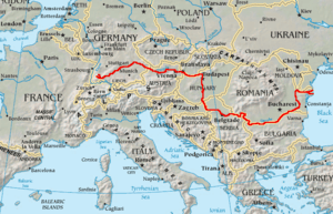 | |
|---|---|---|
| Cities | ||
| Tributaries | ||
| See also | ||
Capital: Lovech | ||
| Villages |
|  |
| Landmarks | ||
| Culture |
| |
| Notable people | ||
| Wikimedia Commons has media related to Osam. |
This article is issued from
Wikipedia.
The text is licensed under Creative Commons - Attribution - Sharealike.
Additional terms may apply for the media files.