Vit
| Vit | |
|---|---|
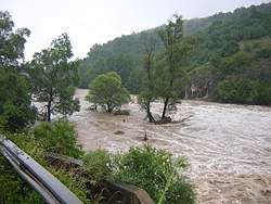 The Vit near Toros during the 2005 European floods | |
| Country | Bulgaria |
| Physical characteristics | |
| River mouth |
Danube 43°40′53″N 24°44′34″E / 43.6813°N 24.7428°ECoordinates: 43°40′53″N 24°44′34″E / 43.6813°N 24.7428°E |
| Length | 167.5 km (104.1 mi)[1] |
| Basin features | |
| Progression | Danube→ Black Sea |
| Basin size | 3,228 km2 (1,246 sq mi)[1] |
The Vit also Vid (Bulgarian: Вит; Latin: Utus) is a river in central northern Bulgaria with a length of 168 km. It is a tributary of Danube. The source of the Vit is in Stara Planina, below Vezhen Peak at an altitude of 2,030 m, and it empties into the Danube close to Somovit. The river has a watershed area of 3,228 km², its main tributaries being Kamenska reka, Kalnik and Tuchenitsa.
Towns on or close to the river include Teteven, Pleven, Dolni Dabnik, Dolna Mitropoliya and Gulyantsi.
The river's name comes from Thracian Utus, a word for "water" (cf. IE *udes).
Vit Ice Piedmont in Antarctica is named after the river.
References
| Countries |  | |
|---|---|---|
| Cities | ||
| Tributaries | ||
| See also | ||
| Wikimedia Commons has media related to Vit. |
This article is issued from
Wikipedia.
The text is licensed under Creative Commons - Attribution - Sharealike.
Additional terms may apply for the media files.