Szczytno
| Szczytno | |||
|---|---|---|---|
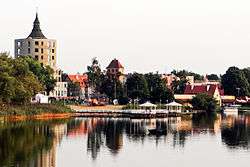 View of the lake. | |||
| |||
 Szczytno | |||
| Coordinates: 53°33′46″N 20°59′7″E / 53.56278°N 20.98528°E | |||
| Country |
| ||
| Voivodeship | Warmian-Masurian | ||
| County | Szczytno County | ||
| Gmina | Szczytno (urban gmina) | ||
| Established | 1359 | ||
| Town rights | 1720 | ||
| Government | |||
| • Mayor | Danuta Górska | ||
| Area | |||
| • Total | 9.96 km2 (3.85 sq mi) | ||
| Population (2007) | |||
| • Total | 27,013 | ||
| • Density | 2,700/km2 (7,000/sq mi) | ||
| Time zone | UTC+1 (CET) | ||
| • Summer (DST) | UTC+2 (CEST) | ||
| Postal code | 12-100 to 12-102 | ||
| Area code(s) | +48 89 | ||
| Car plates | NSZ | ||
| Website | http://miastoszczytno.pl/ | ||


Szczytno [ˈʂt͡ʂɨtnɔ] (German: Ortelsburg)[1] is a town in north-eastern Poland with 27,970 inhabitants (2004). Szczytno is situated in the Warmian-Masurian Voivodship (since 1999), but was previously in Olsztyn Voivodship (1975-1998).
Olsztyn-Mazury Regional Airport, located nearby, is the most important airport of the Masurian region. Szczytno, which is located on the Olsztyn – Ełk line, and used to be a railroad junction until Polish Railways closed minor connections stemming from the town towards Czerwonka and Wielbark.
History
Near today's Szczytno are the only known megalithic tombs in Warmia-Masuria and the former East Prussia. The town was originally an Old Prussian settlement.
Between 1350 and 1360 Ortolf von Trier, a knight of the Teutonic Order and the Komtur of Elbląg (Elbing), founded a fort in the Old Prussian region of Galindia,[2] probably near an Old Prussian settlement. The first mention of the fort, eponymously named Ortulfsburg, was a document from September 1360, after Ortolf invited Masovian colonists, among whom the settlement became known as Szczytno.[3] The first custodian of the settlement was Heinrich Murer. In 1370 the wooden fort was destroyed by Lithuanians led by Kęstutis, after which it was rebuilt using stone. In German, the name Ortulfsburg gradually morphed into Ortelsburg. The settlement grew in size owing to its location on a trade route from Warsaw to Königsberg (now Kaliningrad).
In the wake of the Polish-Lithuanian victory over the Order at Tannenberg/Stẹbark in 1410, the castle was occupied by Polish troops during the Thirteen Years' War. With its inclusion in the Ducal Prussia in 1525, it lost its importance as a border fortress and began to decline. Margrave and regent George Frederick (1577–1603), who enjoyed hunting nearby, began the redevelopment of the area. Among his projects was the rebuilding of the castle into a hunting lodge.
King Władysław IV Vasa of Poland visited the town from 1628–29 and in 1639.[3] Ortelsburg suffered from 17th century fires and the plague in 1656. The town became part of the Kingdom of Prussia in 1701. King Frederick William I of Prussia granted Ortelsburg its town charter in 1723.[2]
Prussian King Frederick William III and Queen Louise arrived in the town on 23 November 1806 while fleeing French troops during the Fourth Coalition.[4] The town was briefly the seat of the Prussian government, and Frederick William released his Ortelsburger Publicandum — a series of constitutional, administrative, social and economic reforms — there on 1 December 1806.[5] Later that month, French troops occupied and plundered Ortelsburg. Six years later the town was forced to host numerous troops of the Napoleon's Grande Armée, which invaded Russia.
Ortelsburg became the seat of Landkreis Ortelsburg, one of the largest in East Prussia, in 1818 after the Prussian administrative reforms were implemented, and Ritter von Berg was chosen as the first district administrator. The town became part of the German Empire in 1871 during the unification of Germany.
Ortelsburg was almost completely destroyed at the beginning of World War I by troops of the Russian Empire, 160 houses and 321 commercial buildings burned down between 27 and 30 August 1914.[6] The town's recovery was supported by contributions raised in Berlin and Vienna.[7] In 1916 the Viennese modernist Josef Hoffmann visited Ortelsburg, his plans for a new town hall were not carried out. A new town hall, an example of Nazi architecture in East Prussia, was finally built in 1938 and listed as a historical monument in 1991.[6][8] The initial plans for the reconstruction of the town were based on Bruno Möhring's work but carried out by several local architects.[6]
The East Prussian plebiscite of 11 July 1920 resulted in 5,336 votes for Germany and 15 for Poland.[9]
During the interwar period, Polish-speaking residents of the region organized Samopomoc Mazurska ("Masurian Self-Help"), an organisation for the protection of Poles in southern East Prussia. A Polish activist Jerzy Lanc was killed during his attempt to establish a Polish school.[3] Ortelsburg was the location of the Polish House, in which meetings of Polish journalists and activists were held. The Polish House was the headquarters of such organisations as "Zjednoczenie Mazurskie", "Samopomoc Mazurska" and the Union of Poles in Germany.[3] Today the building is dedicated to the memory of the people and institutions that were engaged in Polish movement in Masuria.[3]
In the German federal election, March 1933, after the Nazi seizure of power and suppression of anti-Nazi political factions, the Nazi Party polled 76.6% of vote in Ortelsburg, compared to the national German average of only 43.9%.[10]
Near the end of World War II, most of the town's German population fled before the Red Army. Those who remained behind were either killed in the final months of the war or expelled after its end. The city was placed under Polish administration in 1945 under border changes promulgated at the Potsdam Conference, renamed Szczytno and gradually repopulated with Poles.
The nearby Szczytno-Szymany International Airport, as well as Stare Kiejkuty, a military intelligence training base, came under scrutiny in late 2005 as one of the suspected "black sites" (secret prisons or transfer stations) used in the CIA's program of so-called extraordinary rendition of accused terrorists. The existence of the nearby training base and the record of CIA-registered affiliated aircraft having landing at Szczyton-Szymany have been unequivocally confirmed, but the Polish government has repeatedly denied any involvement of these facilities in extraordinary renditions.
Notable residents
- Julie Salinger (1863–1942), politician
- Rose Scooler, née Guttfeld, (1882-1985), survivor of Theresienstadt concentration camp
- Hans Jürgen von der Wense (1894–1966) was a German poet, composer, photographer, aphorist and hiker.
- Wolfgang Koeppen (1906–1996), German author, whose autobiographical film evoking a lost rural idyll, Es war einmal in Masuren, was set here.
- Horst Kopkow (1910–1996), Nazi spy who cooperated with British intelligence after World War II.
- Hans-Peter Reinecke (1926–2003), German musicologist.
- Christine Laszar (born 1931), German actress
- Klaus Kilimann (born 1938) is a physicist who became an SPD politician after 1989
- Krzysztof Klenczon (1942–1981), Polish musician.
- Waldemar Kobus, (born 1966) German actor
- Maurycy Stefanowicz (born 1976) is a Polish musician and guitarist
- Konrad Bukowiecki, (born 1997) athlete competing primarily in the shot put.
Notes
- ↑ Kaemmerer, Margarete (2004). Ortsnamenverzeichnis der Ortschaften jenseits von Oder u. Neiße (in German). p. 121. ISBN 3-7921-0368-0.
- 1 2 szczytno.pl (in Polish)
- 1 2 3 4 5 Municipal website history section Archived 2008-04-04 at the Wayback Machine.
- ↑ Oster, Uwe A. (2010). Preussen: Geschichte eines Königreichs (in German). p. 223. ISBN 978-3-492051910.
- ↑ Stübig, Heinz (2012). "Zwischen Reformzeit und Reichsgründung" (in German). p. 49. ISBN 978-3-8305-3140-1.
- 1 2 3 Salm, Jan (2012). Ostpreußische Städte im Ersten Weltkrieg – Wiederaufbau und Neuerfindung (in German). Oldenbourg Wissenschaftsverlag. pp. 168 ff. ISBN 978-3-486-71209-4.
- ↑ Pölking, Hermann (2012). "Ostpreussen, Biographie einer Provinz" (in German). ISBN 978-3-89809-108-4.
- ↑ nid.pl (in Polish)
- ↑ Marzian, Herbert; Kenez, Csaba (1970). Selbstbestimmung für Ostdeutschland – Eine Dokumentation zum 50 Jahrestag der ost- und westpreussischen Volksabstimmung am 11. Juli 1920 (in German).
- ↑ A. Kossert, Masuren - Ostpreussens vergessener Süden, ISBN 3-570-55006-0
References
| Seat |
|  |
|---|---|---|
| Urban-rural gmina | ||
| Rural gminas | ||