Oquossoc, Maine
| Oquossoc, Maine | |
|---|---|
| Village | |
 Oquossoc | |
| Coordinates: 44°57′59″N 70°46′25″W / 44.96639°N 70.77361°WCoordinates: 44°57′59″N 70°46′25″W / 44.96639°N 70.77361°W | |
| Country | United States |
| State | Maine |
| County | Franklin |
| Elevation | 1,529 ft (466 m) |
| Time zone | UTC-5 (Eastern (EST)) |
| • Summer (DST) | UTC-4 (EDT) |
| ZIP code | 04964 |
| Area code(s) | 207 |
| GNIS feature ID | 572751[1] |
Oquossoc is an unincorporated village in the town of Rangeley, Franklin County, Maine, United States. The community is located at the junction of Maine State Route 4 and Maine State Route 17 at the northwest tip of Rangeley Lake. Oquossoc has a post office with ZIP code 04964, which opened on December 17, 1902.[2][3]
References
- ↑ "Oquossoc". Geographic Names Information System. United States Geological Survey.
- ↑ United States Postal Service. "USPS - Look Up a ZIP Code". Retrieved July 26, 2015.
- ↑ "Postmaster Finder - Post Offices by ZIP Code". United States Postal Service. Retrieved July 26, 2015.
Municipalities and communities of Franklin County, Maine, United States | ||
|---|---|---|
| Towns | 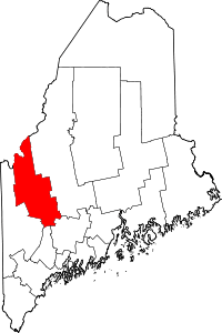 | |
| Plantations | ||
| Unorganized territories | ||
| CDPs | ||
| Other villages | ||
| Footnotes | ‡This populated place also has portions in an adjacent county | |
This article is issued from
Wikipedia.
The text is licensed under Creative Commons - Attribution - Sharealike.
Additional terms may apply for the media files.