Dryden, Maine
| Dryden, Maine | |
|---|---|
| Village | |
 | |
 Dryden | |
| Coordinates: 44°35′12″N 70°12′35″W / 44.58667°N 70.20972°WCoordinates: 44°35′12″N 70°12′35″W / 44.58667°N 70.20972°W | |
| Country | United States |
| State | Maine |
| County | Franklin |
| Elevation | 482 ft (147 m) |
| Time zone | UTC-5 (Eastern (EST)) |
| • Summer (DST) | UTC-4 (EDT) |
| ZIP code | 04225 |
| Area code(s) | 207 |
| GNIS feature ID | 565324[1] |
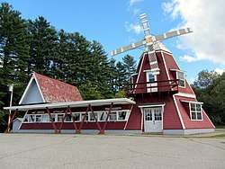
Dryden is an unincorporated village in the town of Wilton, Franklin County, Maine, United States. The community is located along U.S. Route 2, Maine State Route 4, and Maine State Route 156 6.5 miles (10.5 km) south-southwest of Farmington. Dryden has a post office with ZIP code 04225, which opened on January 30, 1899.[2][3]
References
- ↑ "Dryden". Geographic Names Information System. United States Geological Survey.
- ↑ United States Postal Service. "USPS - Look Up a ZIP Code". Retrieved April 19, 2017.
- ↑ "Postmaster Finder - Post Offices by ZIP Code". United States Postal Service. Retrieved April 19, 2017.
Municipalities and communities of Franklin County, Maine, United States | ||
|---|---|---|
| Towns | 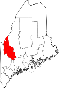 | |
| Plantations | ||
| Unorganized territories | ||
| CDPs | ||
| Other villages | ||
| Footnotes | ‡This populated place also has portions in an adjacent county | |
This article is issued from
Wikipedia.
The text is licensed under Creative Commons - Attribution - Sharealike.
Additional terms may apply for the media files.