Mooselookmeguntic, Maine
| Mooselookmeguntic, Maine | |
|---|---|
| Populated place | |
 Mooselookmeguntic | |
| Coordinates: 44°57′48″N 70°47′34″W / 44.9633873°N 70.7928470°WCoordinates: 44°57′48″N 70°47′34″W / 44.9633873°N 70.7928470°W | |
| Country | United States |
| State | Maine |
| County | Franklin |
| Town | Rangeley |
| Elevation | 1,480 ft (450 m) |
Mooselookmeguntic is a populated place in Franklin County, Maine.[1] It is located in the western part of the town of Rangeley, at the northern end of Maine State Route 4, 1 mile (1.6 km) west of Oquossoc. The community is on the east shore of the north end of Mooselookmeguntic Lake, where it merges with Cupsuptic Lake. It is part of the Rangeley Lakes region of northwestern Maine.
Mooselookmeguntic is one of the longest single-word, unhyphenated place names in the United States recognized by the U.S. Board on Geographic Names.[2] At 17 characters, it is tied with Kleinfeltersville, Pennsylvania.
Geology of Mooselookmeguntic
A publication of the Maine Geological Survey describes some of the bedrock just south of Lake Mooselookmeguntic as:
- "Mooselookmeguntic pluton and related bodies. Primarily a medium-grained, two mica adamellite. Some pegmatite."[3]
References
- ↑ U.S. Geological Survey Geographic Names Information System: Mooselookmeguntic, Maine
- ↑ "Domestic Names - Frequently Asked Questions (FAQs)". U.S. Board on Geographic Names. Retrieved April 9, 2012.
- ↑ Guidotti, Charles W. (1977). Reconnaissance Bedrock Geology of the Oquossoc Quadrangle, Maine (PDF). Maine Geological Survey.
Municipalities and communities of Franklin County, Maine, United States | ||
|---|---|---|
| Towns | 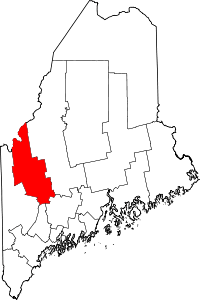 | |
| Plantations | ||
| Unorganized territories | ||
| CDPs | ||
| Other villages | ||
| Footnotes | ‡This populated place also has portions in an adjacent county | |
This article is issued from
Wikipedia.
The text is licensed under Creative Commons - Attribution - Sharealike.
Additional terms may apply for the media files.