Old Mine Road Historic District
|
Old Mine Road Historic District | |
 | |
 | |
| Nearest city | Wallpack Center, New Jersey |
|---|---|
| Coordinates | 41°09′15″N 74°55′04″W / 41.15417°N 74.91778°WCoordinates: 41°09′15″N 74°55′04″W / 41.15417°N 74.91778°W |
| Area | 687 acres (2.78 km2) |
| Architectural style | Early Republic, Late Victorian, Early Colonial Dutch |
| NRHP reference # | 80000410[1] |
| Added to NRHP | December 3, 1980 |
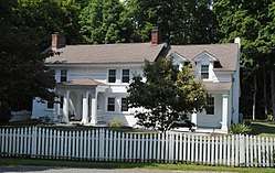
The Old Mine Road Historic District, in Sussex County, New Jersey and Warren County, New Jersey near Wallpack Center, New Jersey, was listed on the National Register of Historic Places in 1980. It is a 687 acres (2.78 km2) historic district which included 24 contributing buildings and five contributing sites.[1]
It includes Early Republic, Late Victorian, and Early Colonial Dutch architecture.[2]
Old Mine Road refers to a connected series of 100 miles of roads that connect the Hudson River in Kingston, New York to the Delaware River in Sussex and Warren counties. This district is a linear district along 26 miles of the Old Mine Road, just in Sussex and Warren counties. In this stretch, it is known as County Route 521, Delaware Mine Road, Old Mine Road, River Road and various other local designations.[2]
The stretch runs through Montague, Sandyston, Walpack and Pahaquarry townships.[2]
Parts of the district were documented in the Historic American Buildings Survey in 1967, 1969, 1970, and 1971.[2]
References
- 1 2 National Park Service (2013-11-02). "National Register Information System". National Register of Historic Places. National Park Service.
- 1 2 3 4 Wayne K. Bodle; Clifford Tobias (July 16, 1980). "National Register of Historic Places Inventory/Nomination: Old Mine Road Historic District / Old Mine Road". National Park Service. Retrieved June 23, 2018. With accompanying 29 photos from 1977
| Topics | |
|---|---|
| Lists by states |
|
| Lists by insular areas | |
| Lists by associated states | |
| Other areas | |
| |