Old Crow Airport
| Old Crow Airport | |||||||||||
|---|---|---|---|---|---|---|---|---|---|---|---|
 | |||||||||||
| Summary | |||||||||||
| Airport type | Public | ||||||||||
| Operator | Government of Yukon | ||||||||||
| Location | Old Crow, Yukon | ||||||||||
| Time zone | PST (UTC−08:00) | ||||||||||
| • Summer (DST) | PDT (UTC−07:00) | ||||||||||
| Elevation AMSL | 818 ft / 249 m | ||||||||||
| Coordinates | 67°34′12″N 139°50′24″W / 67.57000°N 139.84000°WCoordinates: 67°34′12″N 139°50′24″W / 67.57000°N 139.84000°W | ||||||||||
| Map | |||||||||||
 CYOC Location in Yukon | |||||||||||
| Runways | |||||||||||
| |||||||||||
| Statistics (2010) | |||||||||||
| |||||||||||
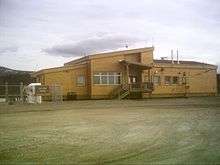
Old Crow Airport (IATA: YOC, ICAO: CYOC) is located in Old Crow, Yukon, Canada, and is operated by the Yukon government. The gravel runway is 5,022 ft × 100 ft (1,531 m × 30 m) and is at an elevation of 821 ft (250 m). The airport is extremely important to the community, which is not accessible by road.
The airport is classified as an airport of entry by Nav Canada and is staffed by the Canada Border Services Agency. CBSA officers at this airport currently can handle general aviation aircraft only, with no more than 15 passengers.[1][4]
Airlines and destinations
| Airlines | Destinations |
|---|---|
| Air North | Dawson City, Inuvik |
References
- 1 2 Canada Flight Supplement. Effective 0901Z 19 July 2018 to 0901Z 13 September 2018.
- ↑ Synoptic/Metstat Station Information
- ↑ Total aircraft movements by class of operation
- ↑ Old Crow Airport at Canada Border Services Agency
External links
- Past three hours METARs, SPECI and current TAFs for Old Crow Airport from Nav Canada as available.
| By name | |
|---|---|
| By location indicator | |
| By province/territory | |
| By area | |
| National Airports System | |
| Related | |
| |
This article is issued from
Wikipedia.
The text is licensed under Creative Commons - Attribution - Sharealike.
Additional terms may apply for the media files.