Ola, Nevada
| Ola, Nevada | |
|---|---|
| Ghost town | |
 Ola exit on Interstate 80 | |
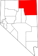
 Ola Location in the state of Nevada  Ola Ola (the US) | |
| Coordinates: 40°43′17″N 114°08′48″W / 40.72139°N 114.14667°WCoordinates: 40°43′17″N 114°08′48″W / 40.72139°N 114.14667°W | |
| Country | United States |
| State | Nevada |
| County | Elko |
| Elevation | 4,626 ft (1,410 m) |
| Time zone | UTC-8 (PST) |
| • Summer (DST) | UTC-7 (PDT) |
Ola is a ghost town in Elko County, Nevada, United States.[1] It is located along Interstate 80 just west of West Wendover.
References
This article is issued from
Wikipedia.
The text is licensed under Creative Commons - Attribution - Sharealike.
Additional terms may apply for the media files.