Ohio State Route 88
| ||||
|---|---|---|---|---|
 | ||||
| Route information | ||||
| Maintained by ODOT | ||||
| Length | 48.31 mi[1] (77.75 km) | |||
| Existed | 1923 – present | |||
| Major junctions | ||||
| South end |
| |||
| East end |
| |||
| Location | ||||
| Counties | Portage, Geauga, Trumbull | |||
| Highway system | ||||
| ||||

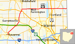
State Route 88 (SR 88) is a highway generally running in an east–west direction in the northeastern portion of the U.S. state of Ohio. Its southern terminus is in Portage County at Ohio State Route 59; at the intersection of Freedom Street with Main Street in Ravenna.[1]Route 88 is labeled north-south southwest of US 422 and Ohio 528, and labeled east-west east of US 422 and Ohio 528. Route 88 follows a northerly direction for a little more than a mile along Freedom Street, to the State Route 14 and State Route 44 concurrency bypass. From here, the route heads in a northeasterly direction. Its next intersection is with State Route 700, at the southern terminus of the latter route. A quarter mile further to the northeast, Route 88 joins State Route 303 for about a half mile. State Route 88 then continues northeast, crossing over Interstate 80 and The Ohio Turnpike, before turning due north as it enters Garrettsville. Here, as South Street, the route intersects with State Route 82 (State Street), then becomes North Street before exiting the corporation limits.
The route continues northward, entering Geauga County, becoming McCall Road here, and intersects with U.S. Route 422 in Parkman; this is also the southern terminus of State Route 528, which overlaps State Route 88 (first as Main Street, and then Madison Road). State Route 168’s southern terminus is two blocks north, and then about a mile north of Parkman, State Route 88 leaves the concurrency and continues due east as Nash Road, and then becomes Greenville Road in Trumbull County.
The route passes through West Farmington as Main Street, then continues as Greenville Road, intersecting with State Route 534, State Route 45 at Bristolville, and State Route 46. Stata Route 88 crosses over State Route 11 before joining with State Route 5 (Warren-Meadville Road), which enters from the southwest about ½ mile before they intersect with State Route 193 (Youngstown-Kingsville Road). About 1½ miles later, State Route 88 leaves the concurrency and continues east as Greenville Road to its last intersection at State Route 7 in Vernon before its eastern terminus at the Pennsylvania state line, where Pennsylvania Route 358 (Vernon Road) continues east.
History
SR 88 was commissioned in 1923, on its current alignment between Ravenna and Parkman.[2][3] In 1927 the route was extended east to the Pennsylvania state line.[4][5] The highway between Ravenna and SR 7 was paved in 1928.[5][6] The section of road between SR 7 and the Pennsylvania state line was paved in 1933.[7][8]
Major intersections
| County | Location | mi | km | Destinations | Notes |
|---|---|---|---|---|---|
| Portage | Ravenna | 0.00 | 0.00 | Southern terminus of SR 88. | |
| 1.26 | 2.03 | ||||
| Freedom Township | 7.18 | 11.56 | Southern terminus of SR 700. | ||
| 7.42 | 11.94 | Northern terminus of SR 303 concurrency. | |||
| 7.95 | 12.79 | Southern terminus of SR 303 concurrency. | |||
| Garrettsville | 12.00 | 19.31 | |||
| Nelson Township | 13.71 | 22.06 | |||
| Geauga | Parkman | 18.52 | 29.81 | Southern termini of SR 168 and SR 528 and their concurrencies with SR 88. | |
| Parkman Township | 18.73 | 30.14 | Northern terminus of SR 168 concurrency. | ||
| 19.81 | 31.88 | Northern terminus of SR 528 concurrency. | |||
| Trumbull | Farmington Township | 25.32 | 40.75 | ||
| Bristol Township | 29.81 | 47.97 | |||
| Mecca Township | 36.74 | 59.13 | |||
| 36.80 | 59.22 | ||||
| Johnston Township | 40.25 | 64.78 | Southern terminus of SR 5 concurrency. | ||
| 41.91 | 67.45 | Northern terminus of SR 5 concurrency. | |||
| Vernon Township | 45.58 | 73.35 | |||
| 48.31 | 77.75 | Eastern terminus of SR 88 at Pennsylvania state line | |||
1.000 mi = 1.609 km; 1.000 km = 0.621 mi
| |||||
References
Route map:
- 1 2 Ohio Department of Transportation. "Technical Services Straight Line Diagrams". Retrieved April 30, 2010.
- ↑ Ohio Department of Highways and Public Works (April 1922). Map of Ohio State Highways Showing All Improved Roadways and Indicating System Constructed Under Administration of Gov. Harry L. Davis (PDF) (Map). c. 1:563,200. Columbus: Ohio Department of Highways and Public Works. Retrieved October 28, 2013.
- ↑ Ohio Department of Highways and Public Works (July 1923). Map of Ohio Showing State Routes (PDF) (Map). 1:760,320. Columbus: Ohio Department of Highways and Public Works. Retrieved October 28, 2013.
- ↑ Ohio Department of Highways and Public Works (August 1, 1926). Map of Ohio Showing State Routes (PDF) (Map). 1:760,320. Columbus: Ohio Department of Highways and Public Works. OCLC 5673562. Retrieved October 28, 2013.
- 1 2 Ohio Department of Highways and Public Works (June 1, 1927). Map of Ohio Showing State Routes (PDF) (Map). 1:760,320. Columbus: Ohio Department of Highways and Public Works. OCLC 5673562. Retrieved October 28, 2013.
- ↑ Ohio Department of Highways (August 1, 1928). Map of Ohio Showing State Highway System (PDF) (Map). 1:760,320. Columbus: Ohio Department of Highways. OCLC 5673562, 7434854. Retrieved October 28, 2013.
- ↑ Ohio Department of Highways (1932). Map of Ohio Showing State Highway System (PDF) (Map). 1:760,320. Columbus: Ohio Department of Highways. OCLC 5673562, 7231704. Retrieved October 28, 2013.
- ↑ Ohio Department of Highways (1933). Map of Ohio Showing State Highway System (PDF) (Map). 1:760,320. Columbus: Ohio Department of Highways. OCLC 5673562, 7237035, 837961470. Retrieved October 28, 2013.