Ognon (Franche-Comté)
| Ognon | |
|---|---|
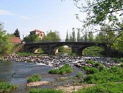 The Ognon near Lure. | |
_(carte).jpg) Map and Location | |
| Country | France |
| Physical characteristics | |
| Main source |
Vosges mountains ±900 m (3,000 ft) |
| River mouth |
Saône 47°18′51″N 5°26′4″E / 47.31417°N 5.43444°ECoordinates: 47°18′51″N 5°26′4″E / 47.31417°N 5.43444°E |
| Length | 214 km (133 mi) |
| Discharge |
|
| Basin features | |
| Progression | Saône→ Rhône→ Mediterranean Sea |
| Basin size | 2,308 km2 (891 sq mi) |
The Ognon is a river of eastern France. It is a left tributary of the Saône, which it joins in Pontailler-sur-Saône. Its source is in Haut-du-Them-Château-Lambert in the Vosges mountains near the Ballon d'Alsace. Its length is 214 km (133 mi) and its basin area is 2,308 km2 (891 sq mi).[1]
The Ognon flows through the following départements and towns:
Tributaries
Some of its tributaries include:
- The Rahin
- The Scey
- The Reigne
- The Buthiers
References
- http://www.geoportail.fr
- Website of an association of owners of historical sites in the Ognon valley (french - english)
| Wikimedia Commons has media related to Ognon (Franche-Comté). |
This article is issued from
Wikipedia.
The text is licensed under Creative Commons - Attribution - Sharealike.
Additional terms may apply for the media files.