Octavia Boulevard
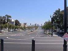
Octavia Boulevard (designated as Octavia Street north of Hayes Street) is a major street in San Francisco, California that replaced the Hayes Valley portion of the damaged two-level Central Freeway. Once a portion of Octavia Street alongside shadowy, fenced-off land beneath the elevated U.S. Route 101 roadway, Octavia Boulevard was redeveloped and redesigned upon the suggestion of Mark Jolles of San Francisco.
At a public meeting he compared the central freeway traffic volumes to those on 8th and 9th street south of Market. Mark noted that Octavia as a boulevard could handle the same volumes and better use the freeway's right-of-way for additional street space and new housing without the visual impact of an elevated roadway. Comparable examples cited were the configuration of Park Presidio Blvd, Funston Street, and 14th Avenue in the Richmond District and Sunset Boulevard in the Sunset District, both in San Francisco. A boulevard design also provides for better access to the overall street grid. This benefits motorists who can easily adjust their route when there is congestion. For elevated freeways, due to limited access to local streets, traffic cannot readily adjust during periods of congestion. Also noted was that during heavy traffic, travel times on the boulevard would be comparable to those of a backed-up elevated freeway. This suggests there was no benefit to replacing an urban freeway with one of the same limited access design.
The boulevard is merely four blocks long from Market to Fell Street, containing multiple lanes that separate local and through traffic. On Octavia, homes and businesses located immediately on the street are served by the quieter outer roadways, while lanes leading to and from the rebuilt Central Freeway spur connect faster traffic with the inner roadways. Having replaced a freeway, the boulevard distributes traffic smoothly and evenly throughout the immediate neighborhood, while maintaining the links to the major San Francisco traffic arterials that the old elevated freeway used to connect to directly, including Fell and Oak Streets (which serve the city's western neighborhoods) and Franklin and Gough Streets (which serve northern neighborhoods and the Golden Gate Bridge). A brand new park named Hayes Green was created as part of the boulevard project. It lies on Octavia between Fell and Hayes Street.
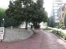
North of Hayes Street, Octavia continues as Octavia Street through the Western Addition, Pacific Heights and Marina neighborhoods to Bay Street, at Fort Mason.
Other freeway removal projects in the San Francisco Bay, due to seismic stability (or collapse), include the replacement of San Francisco's Embarcadero Freeway, and the reuse of the collapsed Cypress Structure's right-of-way in neighboring Oakland.
Origin of name
The name refers to Octavia Gough, sister of Charles H. Gough. A contractor who carried out the planking and paving of many San Francisco streets, Charles served on the commission to design the layout of streets in the Western Addition, according to an obituary published in the San Francisco Call on July 27, 1895.
Related places nearby
Parallel to Octavia and immediately west of it is Gough Street.
Octavia is 8 blocks east of Divisadero, which at the time of its naming was the nearest major north-south thoroughfare. "Octavia" is a name which means, "the eighth".
There is an octagon-shaped building (named The Octagon House at 2645 Gough Street, on the northwest corner of Gough and Green streets. As of 2013, it operates as a historic museum, housing colonial-era folk art and documents.
Today, the Academy of Art University owns and operates a building on the street for housing purposes.[1]
References
- ↑ "Academy of Art University Campus Map" (PDF). academyart.edu. Academy of Art University. Retrieved 18 April 2017.
External links
- SFCityscape.com: Octavia Boulevard
- Market & Octavia Neighborhood Plan City & County of San Francisco.
- Congress for the New Urbanism History of Octavia Boulevard
- Points of Interest near Union Street
- Origins of San Francisco Street Names
| Numbered streets | 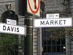 | |
|---|---|---|
| North–south streets |
| |
| East–west streets | ||
| Diagonal streets | ||
| Alleyways | ||
| Routes | ||
Coordinates: 37°46′26″N 122°25′26″W / 37.77389°N 122.42389°W