Lombard Street (San Francisco)
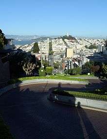
 Lombard Street seen from Coit Tower | |
| Maintained by |
|
|---|---|
| Coordinates | 37°48′07″N 122°25′08″W / 37.80194°N 122.41889°W |
| West end | Presidio Boulevard |
| Major junctions |
|
| East end | The Embarcadero |
Lombard Street is an east–west street in San Francisco, California that is famous for a steep, one-block section with eight hairpin turns. Stretching from The Presidio east to The Embarcadero (with a gap on Telegraph Hill), most of the street's western segment is a major thoroughfare designated as part of U.S. Route 101. The famous one-block section, claimed to be "the crookedest street in the world", is located along the eastern segment in the Russian Hill neighborhood. It is a major tourist attraction, receiving around two million visitors per year and up to 17,000 per day on busy summer weekends, as of 2015.[1]
The street was named after Lombard Street in Philadelphia by San Francisco surveyor Jasper O'Farrell.[2]
Route description
Lombard Street's west end is at Presidio Boulevard inside The Presidio; it then heads east through the Cow Hollow neighborhood. For 12 blocks, between Broderick Street and Van Ness Avenue, it is an arterial road that is co-signed as U.S. Route 101. Lombard Street continues through the Russian Hill neighborhood and to the Telegraph Hill neighborhood. At Telegraph Hill it turns south, becoming Telegraph Hill Boulevard to Pioneer Park and Coit Tower. Lombard Street starts again at Winthrop Street and ends at The Embarcadero as a collector road.[3]
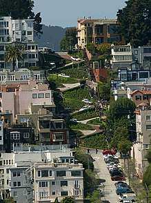
Lombard Street is known for the one-way block on Russian Hill between Hyde and Leavenworth Streets, where eight sharp turns are said to make it the most crooked street in the world. The design, first suggested by property owner Carl Henry[4] and built in 1922,[5] was intended to reduce the hill's natural 27 percent grade,[6] which was too steep for most vehicles. The crooked block is perhaps 600 feet (180 m) long (412.5 feet (125.7 m) straightline), is one-way (downhill) and is paved with red bricks. The sign at the top recommends 5 mph (8 km/h). The segment normally sees around 250 vehicles per hour, with average daily traffic reaching 2630 vehicles in 2013.[1] During peak times, vehicles have to wait up to 20 minutes to enter the Crooked Street segment, in a queue that can reach Van Ness Avenue.[1]
The Powell-Hyde cable car stops at the top of the block on Hyde Street.[7]
By 2017, the area around the curved segment had become a hot-spot of what has been described as "San Francisco's car break-in epidemic."[8]
Today, the Academy of Art University owns and operates a building called Star Hall on the street for housing purposes.[9]
Past residents of Lombard Street include Rowena Meeks Abdy,[10] an early California painter who worked in the style of Impressionism.
Chase scenes in many movies were filmed on the street, including Good Neighbor Sam and What's Up, Doc?.
Gallery
 Looking up Lombard Street
_Sign_Photowalkabout_March_23_2013-8673.jpg) Traffic caution sign at top of switchbacks recommends a top speed of 5 miles per hour (8.0 km/h)
Traffic caution sign at top of switchbacks recommends a top speed of 5 miles per hour (8.0 km/h)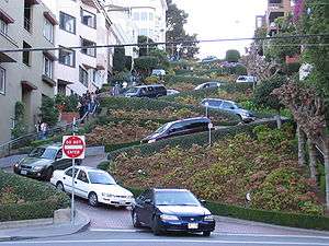 Cars exit from lowest switchback section
 Time-exposure photo at night clearly shows the eight switchbacks
 Sign for Lombard Street at intersection with Leavenworth Street

See also
- 49-Mile Scenic Drive
- Vermont Street, the other San Francisco street claimed to be the "most crooked"[11] has seven turns instead of eight, but its hill is steeper than Lombard's.
- Snake Alley in Burlington, Iowa, once recognized by Ripley's Believe It or Not! as "The Crookedest Street in the World". Like Lombard Street it has eight turns but over a shorter distance.
References
- 1 2 3 San Francisco County Transportation Authority: Lombard Study: Managing Access to the "Crooked Street". February 2017 (PDF)
- ↑ Loewenstein, Louis, K. (1984) Streets of San Francisco: The Origins of Street and Place Names. Don't Call It Frisco Press.
- ↑ Google. "Lombard Street" (Map). Google Maps. Google.
- ↑ Saperstein, Susan (February 2009). "Lombard Street". San Francisco City Guides. Retrieved 2012-09-30.
- ↑ Brown-Martin, Darcey (September–October 2001). "An Honestly Crooked Street". via Magazine.
- ↑ Saperstein, Susan. "Lombard Street". San Francisco City Guides. Retrieved June 22, 2011.
- ↑ "Hyde St & Lombard St". San Francisco Municipal Transportation Agency. Retrieved September 15, 2015.
- ↑ Palomino, Joaquin; O'Neill, Emma; Trumbull, Todd (2018-03-16). "Breaking down San Francisco's car break-in epidemic". The San Francisco Chronicle. Retrieved 2018-03-19.
Parts of San Francisco popular with tourists were hit hardest, including Japantown, Civic Center, the famously curvy stretch of Lombard Street, and the Fisherman’s Wharf/Pier 39 area.
- ↑ "Academy of Art University Campus Map" (PDF). academyart.edu. Academy of Art University. Retrieved 18 April 2017.
- ↑ "Rowena Meeks F. Abdy American 1887–1945 Biography". The Annex Galleries. Retrieved 2012-09-30.
- ↑ "Lombard Street, San Francisco". San Francisco. a view on cities. Retrieved August 27, 2009.
External links

- Tourist Trapped: The Crookedest Street In The World, SFGate Culture Blog
- Lombard Street, SF GuideLines (includes early images)
- Lombard Street on San Francisco To Do
Route map:
| Numbered streets |  | |
|---|---|---|
| North–south streets |
| |
| East–west streets | ||
| Diagonal streets | ||
| Alleyways | ||
| Routes | ||