South Carolina Highway 65
| ||||
|---|---|---|---|---|
| Ocean Blvd | ||||
 | ||||
| Route information | ||||
| Maintained by SCDOT | ||||
| Length | 4.71 mi[1] (7.58 km) | |||
| Existed | 1960s – present | |||
| Major junctions | ||||
| South end |
| |||
| North end |
| |||
| Location | ||||
| Counties | Horry | |||
| Highway system | ||||
| ||||
South Carolina Highway 65 (also called Ocean Blvd, abbreviated SC 65) is the main thoroughfare through North Myrtle Beach in the U.S. state of South Carolina. The Drive is known for the origin of the official state dance, the Carolina Shag.
Route description
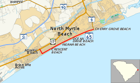
SC 65 begins at U.S. Route 17 (US 17) in North Myrtle Beach, near Atlantic Beach. It travels southeast along 27th Avenue South, heading six blocks towards the shoreline before turning northeast at South Ocean Boulevard, paralleling the ocean and shoreline businesses for the next 3 1⁄2 miles (5.6 km), including an intersection with Main Street. At the intersection with South Carolina Highway 9, SC 65 ends within the community of Cherry Grove Beach.[2]
History
Ocean Drive is often referred to by South Carolinians as the "OD", and still brings throngs of tourists every year, notably at the beginning and end of the season (April and September) for weeklong "Shagging" events.
Major intersections
The entire route is in North Myrtle Beach, Horry County.
| mi[1] | km | Destinations | Notes | ||
|---|---|---|---|---|---|
| 0.00 | 0.00 | ||||
| 2.94 | 4.73 | Main Street | Connects to Robert Edge Parkway | ||
| 4.71 | 7.58 | Southern terminus of SC 9 | |||
| 1.000 mi = 1.609 km; 1.000 km = 0.621 mi | |||||
References
- 1 2 South Carolina Department of Transportation: Statewide Highways 2012. Specifics: . Files: .
- ↑ Google (February 1, 2018). "Overview map of Highway 65" (Map). Google Maps. Google. Retrieved February 1, 2018.
External links
Route map:
| Wikimedia Commons has media related to South Carolina Highway 65. |