North Omaha Creek Bridge
|
North Omaha Creek Bridge | |
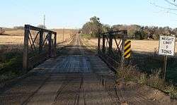 Photo in October 2010 | |
  | |
| Location | Township road over the North Omaha Creek, 3 miles (4.8 km) southwest of Winnebago, Nebraska |
|---|---|
| Coordinates | 42°11′39″N 96°31′52″W / 42.194044°N 96.531003°W |
| Area | less than one acre |
| Built | 1905 |
| Built by | Standard Bridge Co. |
| Architectural style | Pin-connected Pratt truss |
| MPS | Highway Bridges in Nebraska MPS |
| NRHP reference # | 92000727[1] |
| Added to NRHP | June 29, 1992 |
The North Omaha Creek Bridge was a historic Pin-connected Pratt truss bedstead bridge that was built in 1905, located on 26 Road, a north–south rural road in Thurston County, Nebraska.
When photographed in 2010, the bridge was posted with a 9 tonnes (8.9 long tons; 9.9 short tons) weight limit sign.
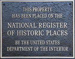
It was listed on the National Register of Historic Places in 1992.[1]
The bridge was 80 feet (24 m) long with a roadway 15.4 feet (4.7 m) wide. It had a timber decking over transverse steel I-beam stringers.[2]

The bridge is apparently no longer extant, as a November 2016 photo, by the same photographer as in 2010, shows a new bridge under construction.
The location is about 6 miles (9.7 km) (by car travel on existing roads) southwest of Winnebago and 5 miles (8.0 km) northwest of Walthill.[note 1]
See also

- List of bridges on the National Register of Historic Places in Nebraska
- National Register of Historic Places listings in Thurston County, Nebraska
Notes
- ↑ By Google Maps, while the NRHP document states the bridge is about 3 miles southwest of Winnebago.
References
- 1 2 National Park Service (2010-07-09). "National Register Information System". National Register of Historic Places. National Park Service.
- ↑ Carl W. McWilliams and Clayton B. Fraser (June 30, 1991). "National Register of Historic Places Registration: North Omaha Creek Bridge / NEHBS Number TSOO-81". National Park Service. Retrieved December 14, 2016. with photo from 1989
External links
- More photos of North Omaha Creek Bridge at Wikimedia Commons
| Topics | |
|---|---|
| Lists by states |
|
| Lists by insular areas | |
| Lists by associated states | |
| Other areas | |
| |