North Omaha Airport
| North Omaha Airport | |||||||||||
|---|---|---|---|---|---|---|---|---|---|---|---|
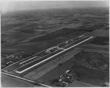 1975 aerial view | |||||||||||
| Summary | |||||||||||
| Airport type | Public use | ||||||||||
| Owner | Keith Edquist | ||||||||||
| Serves | Omaha, Nebraska | ||||||||||
| Elevation AMSL | 1,322 ft / 403 m | ||||||||||
| Coordinates | 41°22′06″N 096°01′21″W / 41.36833°N 96.02250°W | ||||||||||
| Runways | |||||||||||
| |||||||||||
| Statistics (2008) | |||||||||||
| |||||||||||
North Omaha Airport (FAA LID: 3NO) is a privately owned, public-use airport located seven nautical miles (8 mi, 13 km) northwest of the central business district of Omaha, a city in Douglas County, Nebraska, United States.[1]
Facilities and aircraft
North Omaha Airport covers an area of 100 acres (40 ha) at an elevation of 1,322 feet (403 m) above mean sea level. It has one runway designated 17/35 with a concrete surface measuring 2,480 by 40 feet (756 x 12 m).[1]
For the 12-month period ending August 13, 2008, the airport had 14,250 general aviation aircraft operations, an average of 39 per day. At that time there were 58 aircraft based at this airport: 86% single-engine, 12% helicopter and 2% glider.[1]
References
External links
- Resources for this airport:
- FAA airport information for 3NO
- AirNav airport information for 3NO
- FlightAware airport information and live flight tracker
- SkyVector aeronautical chart for 3NO
This article is issued from
Wikipedia.
The text is licensed under Creative Commons - Attribution - Sharealike.
Additional terms may apply for the media files.