North–South Expressway Central Link
| |
|---|---|
|
North–South Expressway Central Link (ELITE Expressway) | |
  North–South Expressway Central Link (Peninsular Malaysia) | |
| Route information | |
|
Part of | |
|
Maintained by PLUS Malaysia Berhad with its subsidiary Projek Lebuhraya Usahasama Berhad (Former concessionaries known as Expressway Lingkaran Tengah Sdn Bhd (ELITE)) | |
| Length | 60 km (40 mi) |
| Existed | 1994 – present |
| History | Completed in 1996 |
| Component highways |
(Shah Alam–Nilai) (Putrajaya Interchange–Putrajaya) (KLIA Interchange–Kuala Lumpur International Airport) |
| Major junctions | |
| North end | Shah Alam, Selangor |
|
| |
| South end | Nilai North, Negeri Sembilan |
| Location | |
| Primary destinations | Shah Alam, Batu Tiga, HICOM, UEP Subang Jaya, Putra Heights, Puchong, Bandar Saujana Putra, Cyberjaya, Putrajaya, Kuala Lumpur International Airport, Nilai |
| Highway system | |

North–South Expressway Central Link, NSECL ![]()
![]()
The expressway is part of the Asian Highway Network of route AH2.
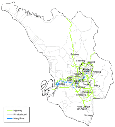
Route background
The Kilometre Zero is located at Shah Alam Interchange in Shah Alam, Selangor and its interchange with the New Klang Valley Expressway E1 and the Guthrie Corridor Expressway E35.
History
The new expressway bypass for the North–South Expressway in the Klang Valley was announced in 1994 in conjunction with the opening of the main routes of the North–South Expressway. Construction started in March 1994 and was completed in August 1997. The Section 1 of the North–South Expressway Central Link from Shah Alam Interchange (NKVE) to USJ (Hicom East) Interchange was opened in June 1996. In October 1997, all of the sections in the North–South Expressway Central Link and KLIA Expressway opened to traffic. When the Kuala Lumpur International Airport (KLIA) was opened on 27 June 1998, it became the main route to the airport replacing the Sultan Abdul Aziz Shah Airport in Subang. The Putrajaya Link which is connected to Putrajaya was opened in 2000.
The expressway is divided into three sections as follows:
- Section 1 of the Expressway, which extends from the Shah Alam Interchange (NKVE) to the USJ (Hicom East) Interchange, inclusive of the ramps in (Ebor North) and out (Ebor South) connecting the Expressway to the Jalan Subang–Batu Tiga 3214.
- Section 2 which extends from just South of the USJ Interchange to the Nilai (North) Interchange and includes that part of the KLIA Expressway up to the bridge crossing Sg. Langat.
- Section 3 includes Putrajaya Interchange, Bandar Baru Nilai Interchange, Salak Tinggi Interchange and the -2.74 km continuation of the KLIA Expressway (KLIA Expressway Extension) 26, just south of Sg. Langat up to the boundary of the Kuala Lumpur International Airport (KLIA).
On September 2003, the company Expressway Lingkaran Tengah Sdn Bhd (ELITE) became a member company of PLUS Expressways Berhad.
Features
- Closed toll system (refer to PLUS)
- Batu Tiga flyover longest in NSE network
- Act as bypass from bustling Kuala Lumpur travelling from north to south and vice versa
- Smooth access to KLIA
- PLUS Speedway (formerly ELITE Speedway) in USJ Rest and Service Area is the first highway go-kart circuit in Malaysia
- Safety CS Team (PROPEL) roadworks
| Batu Tiga flyover Jejambat Batu Tiga | |
|---|---|
| Carries | Motor vehicles |
| Crosses |
Section 13, Shah Alam, Batu Tiga, Federal Highway Damansara River |
| Locale | North–South Expressway Central Link |
| Official name | Batu Tiga flyover |
| Maintained by |
PLUS Malaysia Berhad (Projek Lebuhraya Usahasama Berhad) |
| Characteristics | |
| Design | box girder bridge |
| Total length | 2 km |
| Width | -- |
| Longest span | -- |
| History | |
| Designer |
Government of Malaysia Malaysian Highway Authority (LLM) United Engineers Malaysia Berhad (UEM) |
| Constructed by | United Engineers Malaysia Berhad (UEM) |
| Opened | 1996 |
Batu Tiga flyover
The Batu Tiga flyover is the longest flyover in the North–South Expressway network. The 2 km flyover connects Shah Alam Interchange in the north until Ebor Interchange in the south.
List of interchanges, and rest and service areas
Legend:
- I/C - interchange, I/S - intersection, RSA - Rest and service area, OBR - overhead bridge restaurant, L/B - layby, V/P - vista point, TN - tunnel, T/P - toll plaza, BR - bridge
| State | District | km | Exit | Name | Destinations | Speed limit |
Notes |
|---|---|---|---|---|---|---|---|
| Selangor | Petaling | 0.0 | 601 | Shah Alam I/C | 90 km/h | ||
| BR | Batu Tiga flyover Railway crossing bridge Sungai Damansara bridge |
Length: 2 km | |||||
| 4.3 | 602 | Ebor I/C (North) | On-ramp to southbound only | ||||
| 4.5 | 602 | Ebor I/C (South) | Off-ramp from southbound only | ||||
| 5.3 | 603 | Seafield I/C | |||||
| RSA | USJ OBR & RSA | MUFORS Gallery |
Southbound, accessible from both directions | ||||
| 604 | USJ I/C | Persiaran Kewajipan – UEP Subang Jaya (USJ 1 to USJ 27), Subang Jaya (SS12 to SS19) USJ 21 LRT Station 5 |
|||||
| 13.2 | 605 | Putra Heights I/C | Persiaran Putra Indah – Putra Heights, Bukit Lanchong, Alam Megah (Section 27 & 28), USJ, Putra Heights LRT Station 5 4 |
110 km/h | |||
| Kuala Langat | BR | Sungai Klang bridge | |||||
| 17.0 | 606 | Saujana Putra I/C | Persiaran Saujana Putra – Bandar Saujana Putra, Kampung Lombong |
||||
| 21.0 | 607 | Putrajaya I/C | |||||
| 22.9 | RSA | Dengkil RSA | Northbound | ||||
| 23.6 | RSA | Dengkil RSA | Southbound | ||||
| Gamuda Cove I/C | Gamuda Cove, Cyberjaya | Under construction | |||||
| Sepang | 31.6 | 608 | KLIA I/C | ||||
| BR | Sungai Langat bridge | ||||||
| 609 | Bandar Serenia I/C | Under construction | |||||
| BR | Railway crossing bridge | ||||||
| 610 | Salak Tinggi I/C | Planned | |||||
| BR | Sungai Jenderam bridge | ||||||
| Negeri Sembilan | Seremban | 611 | Bandar Baru Nilai I/C | Planned | |||
| 46.0 | 612 | Nilai North I/C |