Norland, Ontario
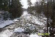
Norland is a small rural community located within the city of Kawartha Lakes, in the Canadian province of Ontario. It is located in a scenic spot on the Gull River at the north end of Shadow Lake, the northernmost Kawartha lake in the Trent River chain. Here a series of three water falls reflect the change in elevation of the land leading north to the Haliburton Highlands.
Norland was named in 1862 by Reverend Bayard Taylor after an African village he'd worked in, Nordland. The name was representative of the villages location at the northern limits of civilization in Victoria County. Norland had been known as McLauchlin Mills for two prior years, after Alexander McLauchlin, who built numerous mills along the Gull River.
Features
- Large mural featuring a nature scene with animals and native people located on the largest building in town situated at the crossroads of Highway 35 and Kawartha Lakes Road 45
- Elliot Falls, a hydroelectric power generating station.
- "The falls" a falls and dam right near the town centre.
- The Old School, the building which now houses the public library, used to also be the municipal building for the tri-township of Laxton-Digby-Longford. The Townships no longer exist since the amalgamation of Victoria County into the City of Kawartha Lakes.
- Municipal water system owned and operated by the City of Kawartha Lakes.
- Municipal wharf located on the Gull River below the falls and upstream of Shadow Lake. Boat access south to Coboconk.
- Several municipal waterfront parks.
- The Links at Monck's Landing Golf Club is located two kilometres northwest of Norland.
The post office services locals with lock boxes and one rural route.
Norland was once mentioned on NBC's Late Night with Conan O'Brien when the show was in Toronto for a week, Mike Myers mentioned the village by name including the only still operating gas station and a resident of Norland.
City of Kawartha Lakes | |||||||
|---|---|---|---|---|---|---|---|
| Towns | 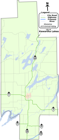 | ||||||
| Villages and unincorporated communities |
| ||||||
| Former townships | |||||||
| Major lakes |
| ||||||
| Topics | |||||||
1) This area lies on the border of an adjacent region, but is part of the Kawartha Lakes census. | |||||||
Coordinates: 44°43′39″N 78°48′43″W / 44.72750°N 78.81194°W