Niambia
For the isopod genus, see Niambia (genus)
| Niambia | |
|---|---|
| Commune | |
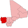
 Horokoto Location in Mali | |
| Coordinates: 13°37′20″N 11°21′08″W / 13.62222°N 11.35222°WCoordinates: 13°37′20″N 11°21′08″W / 13.62222°N 11.35222°W | |
| Country |
|
| Region | Kayes Region |
| Cercle | Bafoulabé Cercle |
| Elevation | 148 m (486 ft) |
| Population (2009 census)[1] | |
| • Total | 7,712 |
| Time zone | UTC+0 (GMT) |
Niambia is a commune in the Cercle of Bafoulabé in the Kayes Region of south-western Mali. The main village (chef-lieu) is Horokoto.[2] In the 2009 census the commune had a population of 7,712.
Population history
| Historical population | ||
|---|---|---|
| Year | Pop. | ±% |
| 1998 (census) | 4,545 | — |
| 2009 (estimate) | 7,712 | +69.7% |
References
- ↑ Resultats Provisoires RGPH 2009 (Région de Kayes) (PDF) (in French), République de Mali: Institut National de la Statistique .
- ↑ Communes de la Région de Kayes (PDF) (in French), Ministère de l’administration territoriale et des collectivités locales, République du Mali, archived from the original (PDF) on 2012-09-19 .
External links
This article is issued from
Wikipedia.
The text is licensed under Creative Commons - Attribution - Sharealike.
Additional terms may apply for the media files.