Niagara Falls, Ontario
| Niagara Falls | |
|---|---|
| City (lower-tier) | |
| City of Niagara Falls | |
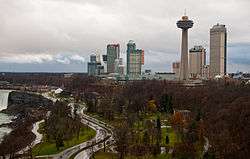 Skyline of Niagara Falls, Ontario | |
| Nickname(s): The Honeymoon Capital of the World, the Falls | |
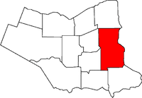 Location of Niagara Falls in the Niagara Region | |
 Niagara Falls Location  Niagara Falls Niagara Falls (Ontario)  Niagara Falls Niagara Falls (Canada) | |
| Coordinates: 43°03′36″N 79°06′24″W / 43.06000°N 79.10667°WCoordinates: 43°03′36″N 79°06′24″W / 43.06000°N 79.10667°W | |
| Country |
|
| Province |
|
| Regional Municipality | Niagara |
| Incorporated | 12 June 1903 |
| Government | |
| • Mayor | Jim Diodati |
| • Governing body | Niagara Falls City Council |
| • MP | Rob Nicholson |
| • MPP | Wayne Gates |
| Area[1][2][3] | |
| • Land | 209.73 km2 (80.98 sq mi) |
| • Urban | 382.68 km2 (147.75 sq mi) |
| • Metro | 1,397.50 km2 (539.58 sq mi) |
| Population (2016)[1][2][3] | |
| • City (lower-tier) | 88,071 (Ranked 64th) |
| • Density | 419.9/km2 (1,088/sq mi) |
| • Urban | 308,596 (Ranked 12th) |
| • Urban density | 545.02/km2 (1,411.6/sq mi) |
| • Metro | 390,317 (Ranked 12th) |
| • Metro density | 279.3/km2 (723/sq mi) |
| Time zone | UTC−5 (EST) |
| • Summer (DST) | UTC−4 (EDT) |
| Forward Sortation Area | L2E to L2J |
| Area code(s) | 905, 289, 365 |
| Highways |
|
| GNBC Code | FEDBA[4] |
| Website |
www |
Niagara Falls is a city in Ontario, Canada. It is on the western bank of the Niagara River in the Golden Horseshoe region of Southern Ontario, with a population of 88,071 at the 2016 census.[1] The municipality was incorporated on 12 June 1903. Across the Niagara River is Niagara Falls, New York.
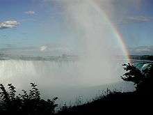
The Niagara River flows over Niagara Falls at this location, creating a natural spectacle which attracts millions of tourists each year.
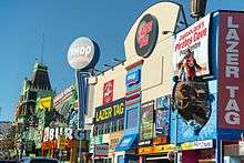
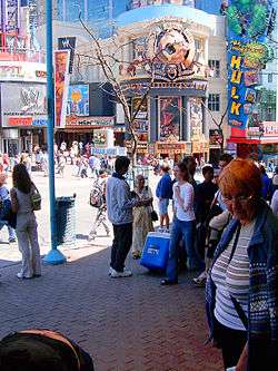
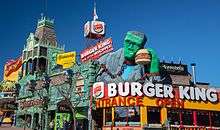
This area, which stretches along the Niagara Parkway and tourist promenade, is particularly concentrated at the brink of the falls. Apart from the river's natural attractions, it includes observation towers, high-rise hotels, souvenir shops, museums, indoor water parks, casinos and theatres, mostly with colourful neon billboards and advertisements, and sufficient parking to accommodate visitors. Further to the north or south, golf courses are operated alongside historic sites from the War of 1812.
History
This area was long part of the Iroquois Confederacy territory: five powerful First Nations mostly along the southern edge of the Great Lakes. The Mohawk, Oneida, Onondaga, Cayuga and Seneca were based largely in present-day New York, ranging from east near the Hudson River, to western areas of Seneca Lake and along Ontario and other Great Lakes.
The Niagara Falls area has had some European settlement since the 17th century. Louis Hennepin, a French priest and missionary, is regarded as the first European to visit the area in the 1670s. French colonists settled mostly in Lower Canada, beginning near the Atlantic, and in Quebec and Montreal. Increased settlement in this area took place during and after the American Revolutionary War, when the British Crown made land grants to Loyalists to help them resettle in Upper Canada and provide some compensation for their losses after the United States became independent. Loyalist Robert Land received 200 acres (81 ha) and was one of the first people of European descent to settle in the Niagara Region. He moved to nearby Hamilton three years later due to the relentless noise of falls.[5]
Tourism started in the early 19th century and has been a vital part of the local economy since that time. The falls became known as a natural wonder, in part to their being featured in paintings by prominent American artists of the 19th century such as Albert Bierstadt. Such works were reproduced as lithographs, becoming widely distributed. In addition, Niagara Falls markets itself as a honeymoon destination; it is the self-proclaimed "honeymoon capital of the world."
In 1856, the Town of Clifton was incorporated. The name of the town was changed to Niagara Falls in 1881. In 1882, the community of Drummondville (near the present-day corner of Lundy's Lane and Main Street) was incorporated as the village of Niagara Falls. The village was referred to as Niagara Falls South to differentiate it from the town. In 1904, the town and village amalgamated to form the City of Niagara Falls.
An Internment camp was set up at The Armoury in Niagara Falls from December 1914 to August 1918.[6]
In 1962, the city amalgamated with the surrounding Stamford Township, resulting in a doubling of population.
With the creation of a Niagara regional government in 1970, the city absorbed the village of Chippawa, Willoughby Township and part of Crowland Township, creating the present-day municipal boundaries.
The city's official historian is Sherman Zavitz, who gives regular radio broadcasts on many aspects of Niagara's history.[7]
Geography
Niagara Falls is approximately 130 km (81 mi) by road from Ontario's capital of Toronto, which is across Lake Ontario to the north. The area of the Niagara Region is approximately 1,800 km2 (690 sq mi).
Topography
The city is built along the Niagara Falls waterfalls and the Niagara Gorge on the Niagara River, which flows from Lake Erie to Lake Ontario.
Climate
The city of Niagara Falls has a humid continental climate (Köppen Dfa/Dfb) which is moderated to an extent in all seasons by proximity to water bodies. Winters are cold, with a January high of −0.4 °C (31.3 °F) and a low of −7.8 °C (18.0 °F).[8] However, temperatures above 0 °C (32.0 °F) are common during winter.[8] The average annual snowfall is 154 centimetres (61 in), in which it can receive lake effect snow from both lakes Erie and Ontario. Summers are warm to hot, with a July high of 27.4 °C (81.3 °F) and a low of 17 °C (62.6 °F).[8] The average annual precipitation is 970.2 millimetres (38 in), which is relatively evenly distributed throughout the year.
| Climate data for Niagara Falls | |||||||||||||
|---|---|---|---|---|---|---|---|---|---|---|---|---|---|
| Month | Jan | Feb | Mar | Apr | May | Jun | Jul | Aug | Sep | Oct | Nov | Dec | Year |
| Record high °C (°F) | 22.2 (72) |
19.5 (67.1) |
26.5 (79.7) |
33.0 (91.4) |
35.0 (95) |
34.6 (94.3) |
38.4 (101.1) |
38.3 (100.9) |
35.6 (96.1) |
32.8 (91) |
24.4 (75.9) |
21.5 (70.7) |
38.4 (101.1) |
| Average high °C (°F) | −0.4 (31.3) |
1.3 (34.3) |
5.9 (42.6) |
12.8 (55) |
19.4 (66.9) |
24.5 (76.1) |
27.4 (81.3) |
26.0 (78.8) |
21.9 (71.4) |
15.1 (59.2) |
8.7 (47.7) |
2.7 (36.9) |
13.8 (56.8) |
| Daily mean °C (°F) | −4.1 (24.6) |
−2.7 (27.1) |
1.2 (34.2) |
7.5 (45.5) |
13.6 (56.5) |
19.1 (66.4) |
22.2 (72) |
21.1 (70) |
17.1 (62.8) |
10.7 (51.3) |
4.9 (40.8) |
−0.7 (30.7) |
9.2 (48.6) |
| Average low °C (°F) | −7.8 (18) |
−6.6 (20.1) |
−3.5 (25.7) |
2.2 (36) |
7.7 (45.9) |
13.7 (56.7) |
17.0 (62.6) |
16.2 (61.2) |
12.3 (54.1) |
6.3 (43.3) |
1.1 (34) |
−4.1 (24.6) |
4.5 (40.1) |
| Record low °C (°F) | −26 (−15) |
−25 (−13) |
−20 (−4) |
−13.5 (7.7) |
−4.4 (24.1) |
2.2 (36) |
5.6 (42.1) |
1.0 (33.8) |
0.0 (32) |
−6.7 (19.9) |
−12.5 (9.5) |
−24 (−11) |
−26 (−15) |
| Average precipitation mm (inches) | 75.6 (2.976) |
61.8 (2.433) |
61.7 (2.429) |
72.0 (2.835) |
86.8 (3.417) |
80.9 (3.185) |
78.9 (3.106) |
79.2 (3.118) |
98.2 (3.866) |
79.7 (3.138) |
91.8 (3.614) |
81.1 (3.193) |
947.5 (37.303) |
| Average rainfall mm (inches) | 27.8 (1.094) |
29.6 (1.165) |
36.7 (1.445) |
66.0 (2.598) |
85.9 (3.382) |
80.9 (3.185) |
78.9 (3.106) |
79.2 (3.118) |
98.2 (3.866) |
79.7 (3.138) |
81.9 (3.224) |
49.3 (1.941) |
794.0 (31.26) |
| Average snowfall cm (inches) | 47.7 (18.78) |
32.2 (12.68) |
25.0 (9.84) |
6.0 (2.36) |
0.9 (0.35) |
0.0 (0) |
0.0 (0) |
0.0 (0) |
0.0 (0) |
0.0 (0) |
9.8 (3.86) |
31.8 (12.52) |
153.5 (60.43) |
| Average precipitation days (≥ 0.2 mm) | 14.4 | 11.4 | 11.3 | 12.6 | 13.5 | 11.3 | 10.9 | 10.8 | 11.2 | 13.0 | 13.0 | 13.4 | 146.6 |
| Average rainy days (≥ 0.2 mm) | 5.0 | 4.5 | 7.2 | 11.6 | 13.4 | 11.3 | 10.9 | 10.8 | 11.2 | 13.0 | 11.1 | 7.7 | 117.9 |
| Average snowy days (≥ 0.2 cm) | 9.8 | 7.7 | 5.0 | 1.6 | 0.08 | 0.0 | 0.0 | 0.0 | 0.0 | 0.0 | 2.4 | 6.6 | 33.2 |
| Source #1: Environment Canada (normals 1981–2010, extremes 1981–2006)[9] | |||||||||||||
| Source #2: Environment Canada (extremes for Niagara Falls 1943−1995)[8] | |||||||||||||
Communities and neighbourhoods
Although more historical and cultural diversity exists, Niagara Falls has 11 communities and 67 neighbourhoods defined by Planning Neighbourhoods and Communities for the City of Niagara Falls.[10]
- Beaverdams
- Hyott
- N.E.C. West
- Nichols
- Shriners
- Warner
- Chippawa
- Bridgewater
- Cummings
- Hunter
- Kingsbridge
- Ussher
- Weinbrenner
- Crowland
- Crowland
- Drummond
- Brookfield
- Caledonia
- Coronation
- Corwin
- Drummond Industrial Basin
- Hennepin
- Leeming
- Merrit
- Miller
- Orchard
- Trillium
- Elgin
- Balmoral
- Central Business District
- Glenview
- Hamilton
- Maple
- Oakes
- Ryerson
- Valleyway
- Grassybrook
- Grassybrook Industrial Basin
- Oakland
- Rexinger
- Northwest
- Carmel
- Kent
- Mulhearn
- Queen Victoria
- Clifton Hill
- Fallsview North
- Fallsview South
- Marineland
- Queen Victoria
- Stamford
- Burdette
- Calaguiro
- Church
- Cullimore
- Gauld
- Ker
- Mitchellson
- Mountain
- N.E.C. East
- Olden
- Pettit
- Portage
- Queensway
- Rolling Acres
- Thompson
- Wallice
- Westlane
- Garner
- Hodgson
- Lundy
- Munro
- Oakwood
- Royal Manor
- Westlane Industrial Basin
- Willoughby
- Niagara River Parkway
- Willoughby
Demographics
| Historical population | ||
|---|---|---|
| Year | Pop. | ±% |
| 1881 | 2,347 | — |
| 1891 | 3,349 | +42.7% |
| 1901 | 4,244 | +26.7% |
| 1911 | 9,248 | +117.9% |
| 1921 | 14,764 | +59.6% |
| 1931 | 19,046 | +29.0% |
| 1941 | 20,371 | +7.0% |
| 1951 | 22,874 | +12.3% |
| 1961 | 22,351 | −2.3% |
| 1971 | 67,163 | +200.5% |
| 1981 | 70,960 | +5.7% |
| 1991 | 75,399 | +6.3% |
| 2001 | 78,815 | +4.5% |
| 2006 | 82,184 | +4.3% |
| 2011 | 82,997 | +1.0% |
| 2016 | 88,071 | +6.1% |
| Ethnic Origin | Population | |
|---|---|---|
| English | 22,880 | |
| Italian | 15,425 | |
| Scottish | 13,910 | |
| Irish | 11,200 | |
| French | 8,710 | |
| Source: 2001 Census of Canada[11] | ||
In 2011, the population of Niagara Falls was 81,300 persons, while the metropolitan area had 422,805. The population of Niagara Falls is older than Canada in general in terms of age structure. Youths under 18 years of age number 19.3%. Some 7,715 (9.5%) inhabitants described themselves as visible minorities (non-white/non-European), with the majority of those Black, Chinese, Filipino and South Asian people.[12][13]
83.97% of Niagara Falls city residents self-identified with Christian denominations. The largest denominations are Catholic (41.99%), Protestant (36.80%), and 5.18% other Christian mostly Eastern Orthodox, 14.10% claimed no religious affiliation, while other religions (1.93%) including Sikh, Jewish, Buddhist, Hindu, and Muslim accounted for the rest.[14]
Economy

With a plentiful and inexpensive source of hydroelectric power from the waterfalls, many electro-chemical and electro-metallurgical industries located there in the early to mid-20th century.
Industry began moving out of the city in the 1970s and 80s because of economic recession and increasing global competition in the manufacturing sector. Tourism increasingly became the city's most important revenue source. Generally speaking, Niagara Falls, Ontario is a more popular destination than Niagara Falls, New York, in part due to the better view of the falls from the Canadian side of the river. In the 20th century, there was a favourable exchange rate when comparing Canadian and U.S. currencies, and Ontario had a greater focus on tourism. Also, Ontario's legal drinking age of 19, in comparison to a legal drinking age of 21 in the U.S., attracts potential alcohol consumers from across the border.
The Ontario government introduced legal gambling to the local economy in the mid-1990s. Casino Niagara precipitated an economic boom in the late 1990s as numerous luxury hotels and tourist attractions were built, and a second casino, Niagara Fallsview, opened in 2004. Both attracted American tourists due in part to the comparatively less expensive Canadian dollar, and despite the opening of the Seneca Niagara Casino on the American side. When the Canadian and US currencies moved closer to parity in the 2000s, Niagara Falls, Ontario continued to be a popular destination for Americans. Its tourist areas had many attractions and a vibrancy, while Niagara Falls, New York languished in a prolonged economic downturn.
In 2004, several tourist establishments in Niagara Falls began adding a three percent marketing fee to bills. The collected money is untraceable, and there are no controls over how each establishment spends it. The Ontario government—concerned tourists could be misled into believing the fees were endorsed by the government—warned hotels and restaurants in 2008 not to claim the fee if it was not being remitted to a legitimate non-profit agency that promotes tourism. The practise continues, and takes in an estimated $15 million per-year from tourists unaware the fee is voluntary and can be removed from their bill.[15][16]
Recent development has been mostly centred on the Clifton Hill and Fallsview areas. The Niagara Falls downtown (Queen Street) is undergoing a major revitalization; the city is encouraging redevelopment of this area as an arts and culture district. The downtown was a major centre for local commerce and night life up until the 1970s, when the Niagara Square Shopping Centre began to draw away crowds and retailers. Since 2006, Historic Niagara has brought art galleries, boutiques, cafés and bistros to the street. Attractions include renovation of the Seneca Theatre.
On 3 October 2012, the Mayor of Niagara Falls opened the new Queen Street Downtown Park featuring a children's playground complete with soft artificial turf, benches, seating, landscaping and the "Water Molecule" sculpture, created by artist Derek Costello.
The city encourages location filming of movies and TV series and many have taken advantage of locations. Recent titles include several currently filming as well as Reliving Marilyn (2017 TV Movie), Fight! (2017), Odd Squad: The Movie (2016)and Blanket Fort: Vada Gets Toxic (2016).[17]
Culture
Some cultural areas of Niagara Falls include Queen Street, Main and Ferry Streets, Stamford Centre and Chippawa Square.[18][19] Community centres that are host to cultural activities include the City of Niagara Falls Museums, Niagara Falls Public Libraries, Coronation 50 Plus Recreation Centre, Club Italia and Scotia Bank Convention Centre.
Visual arts
- Niagara Falls Art Gallery
- Peterson's Community Gallery
Performing arts
- Niagara Falls Centre for the Arts
- Seneca Queen Theatre
Music
- Niagara Music Awards
- Fallsview Casino Resort
- Scotiabank Convention Centre
- Casino Niagara
- Oakes Garden Theatre
- Firemen's Park Summer Series
- Chippawa Square Summer Series
Literacy and literary arts
- Niagara Falls Public Libraries: Victoria Avenue Library, Community Centre Branch, Stamford Centre Branch, Chippawa Branch Library
- Niagara Literary Arts Festival
History
- Niagara History Museum
- Battle Ground Hotel Museum
- Willoughby Historical Museum
- Niagara Military Museum
- Niagara Falls Wedding and Fashion Museum
- Niagara Falls Public Library: Historic Niagara Digital Collections
- Lundy's Lane Historical Society
- Battle of Lundy's Lane Walking Tour
- Historic Drummondville
- Stamford Historic Area
Nature, parks and gardens
- Trillium Awards
- Tree Seedling Sale
- Community Clean Sweep Day
Festivals and events
- Winter Festival of Lights
- Niagara Integrated Film Festival
- Springlicious
- Mount Carmel Fine Art and Music Festival
- Niagara Icewine Festival
- Niagara Woodworking Show
- Family Fun Day at the Museum
- Heritage Info Day at the Museum
- Niagara Falls Sports and Hobby Expo
- Greater Niagara Home and Garden Show
- Canada Day Celebration
- Santa Claus Parade
- Niagara Night of Art
- Niagara Region Jazz Festival
Tourism
Niagara Falls observation attractions

- Tablerock Welcome Centre
- Niagara Hornblower Cruises
- Journey Behind the Falls
- Skylon Tower observation deck
- Weekly fireworks over Niagara Falls
- Nightly illumination of Niagara Falls
- National Helicopters
- Niagara Helicopters
- Niagara Skywheel
Niagara River and Parkway attractions
- Niagara Botanical Gardens
- Floral Clock
- Bird Kingdom
- Spanish Aerocar over the Niagara River whirlpool
- White Water Walk (formerly called the Great Gorge Trip, then the Great Gorge Adventure)[20] at the Niagara River rapids
- Winter Festival of Lights
- Niagara Parks Butterfly Conservatory
- Niagara Heritage Trail
- Dufferin Islands
- Niagara Parks School of Horticulture
- Niagara River Recreation Trail
- Whirlpool Jetboat tours of the Niagara Gorge
- Numerous parkway golf courses
- The Rainbow Carillon, which sounds from the Rainbow Tower
Tourist sector entertainment
- Clifton Hill, Niagara Falls — Tourist promenade featuring a Ripley's Believe It Or Not Museum, arcades, five haunted houses, four wax museums including a Louis Tussauds Wax Works, and themed restaurants including the Hard Rock Cafe and Rainforest Cafe.
- MarineLand — Aquatic theme park
- Casinos—Casino Niagara and Niagara Fallsview Casino Resort
- IMAX Theatre and Daredevil museum
- Greg Frewin Theatre / Las Vegas style magic show.
- Skylon Tower - Revolving dining towering 774 feet (236 m) above Niagara gorge.
- Fallsview Tourist Area
- Fallsview Indoor Waterpark
- Great Wolf Lodge Niagara Falls indoor waterpark
- MGM Studios Plaza
- Queen Street Arts & Culture District
- Konica Minolta Tower Centre - the area's second tower
- Flyboard Niagara - Watersports/leisurely activities
Conventions and conferences
- Scotiabank Convention Centre
- Sheraton on the Falls Hotel and Conference Centre
Sports and active living
Venues
- Niagara Falls Sportsplex
- MacBain Centre
- Gale Centre
- Willoughby Memorial Arena
- Coronation 50 Plus Recreation
- Oakes Park Running Track
Events
- Ride of Silence
- International Marathon
Sports clubs
- Amici Per La Vita Cycling Club
- Niagara Falls Soccer Club
- Niagara Falls Revolver Club Incorporated
- Niagara Bowmen Archery Club
- Niagara Storm Football Club
- Boys and Girls Club of Niagara
- Niagara Wasp Rugby Club
- Niagara Falls Minor Hockey
Sports teams and leagues
| Club | League | Sport | Venue | Established | Championships |
|---|---|---|---|---|---|
| Niagara United | Canadian Soccer League | soccer | Kalar Sports Park | 2010 |
0 |
| FC Niagara Falls Srbija | Niagara Falls Soccer League | soccer | St. George Serbian Orthodox Church | 1974 |
7 |
| Niagara Falls Canucks | Greater Ontario Junior Hockey League | ice hockey | Gale Centre | c. 1971 |
2 |
The Niagara Stars of the defunct Canadian Baseball League played in Welland, Ontario and the Niagara IceDogs play in St. Catharines, Ontario.
Government
Niagara Falls City Council consists of eight councillors and a mayor. City elections take place every four years with the most recent election held on 27 October 2014.[21] Council is responsible for policy and decision making, monitoring the operation and performance of the city, analysing and approving budgets and determining spending priorities. Due to regulations put forward by the Municipal Elections Act 1996, elections are held on the fourth Monday in October except for religious holidays or if a member of council or if the mayor resigns.
Infrastructure
Transportation
Highways

Niagara Falls and Niagara Falls, New York are linked to major highways in Canada and the United States respectively, with the Queen Elizabeth Way acting as a major artery between Toronto and Fort Erie, Ontario. Highway 420 (along with Niagara Regional Road 420) connect the Rainbow Bridge to the QEW. The Whirlpool Bridge is at the end of Bridge Street. The Niagara Parkway is a road operated under the Niagara Parks Commission which connects Niagara-on-the-Lake to Fort Erie via Niagara Falls.
Niagara Falls formerly had King's Highways passing through the city. These included:
- The original routing of Highway 3, (which later became Highway 3A,) which ended at the Whirlpool Rapids Bridge via River Road
- Highway 8, which ended at the Whirlpool Rapids Bridge via Bridge Street
- Highway 20, which ended at the Honeymoon Bridge and later the Rainbow Bridge via Lundy's Lane and Clifton Hill
- The Queen Elizabeth Way followed Roberts Street and Newman Hill to the Rainbow Bridge—later renamed Highway 420
Regional airports
- Buffalo Niagara International Airport in Cheektowaga, New York.
- Toronto Pearson International Airport in Mississauga, Ontario - the primary international airport
- Hamilton/John C. Munro International Airport in Mount Hope, Ontario.
- Niagara Falls International Airport in the Town of Niagara, New York
- St. Catharines/Niagara District Airport in Niagara-on-the-Lake, Ontario
Rail
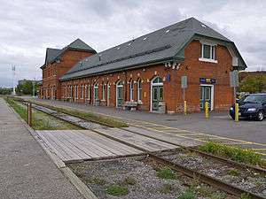
Via Rail Canada and Amtrak jointly provide one train per day in each direction. This is The Maple Leaf which operates between Toronto Union, Niagara, Buffalo, Albany and New York's Penn station), arriving and departing out of the Niagara Falls station. In the summer it offers a bike train service on a limited schedule.[22]
In summer 2009, Go Transit Started a pilot project providing weekend and holiday train service from Toronto to Niagara falls From Mid June to mid October. These GO Trains run seasonally between Toronto Union Station and Niagara Falls at weekends.[23]
At other times, regular hourly GO train services are provided between Toronto Union and Burlington station, where connecting bus services operate to and from the rail station at Niagara.[24]
Bus
- Coach Canada has daily runs to and from Toronto and Buffalo, New York.
- GO Transit offers daily bus service between Niagara and Burlington GO Station.
- Greyhound Canada has daily runs to and from Toronto and Buffalo, New York.
- Megabus has daily runs on its route to New York City starting in Toronto.
- Niagara Transit is the public transit operator in the city.
Cabs and shuttle buses
- Buffalo Airport Shuttle is a reservation based shuttle that operates from the Buffalo Airport to and from Niagara Falls, Buffalo, Hamilton, and Toronto.
- Niagara Livery Service is a taxi/limo company in Niagara.
- 5-0 is a local cab service. A taxi shuttle provides transfers to airports from Buffalo, New York to Niagara Falls, Ontario and Toronto, Ontario.
- Niagara Falls Taxi is a local taxi service from Buffalo, New York and Toronto, Ontario airports back to Niagara.
- Elite Taxi is a local taxi service that provides regular and wheelchair accessible taxi service to and from Niagara Falls, ON. Specialists in airport transfers (Buffalo, Hamilton, Toronto, Niagara Falls, NY).
Active transportation
The City of Niagara Falls is working toward Bike Friendly designation and providing more resources to encourage active transportation.
Education
Niagara Falls has one post-secondary institution in the city and another in the Niagara Region. Niagara is served by the District School Board of Niagara and the Niagara Catholic District School Board which operate elementary and secondary schools in the region. There are also numerous private institutions offer alternatives to the traditional education systems.
Post secondary
- In the Niagara Region: Brock University in St. Catharines
- In the City of Niagara Falls: Niagara College based in Welland, also has campuses in Niagara Falls, Niagara-on-the-Lake and St. Catharines.[25]
High schools
- A. N. Myer Secondary School
- Westlane Secondary School
- Stamford Collegiate
- Saint Michael Catholic High School
- Saint Paul Catholic High School
Library
Niagara Falls is also served by a growing library system composed of four branches,[26] with the main branch in the downtown area.[27] It is visited by over 10,000 people weekly. An extensive online database of photographs and artwork is maintained at Historic Niagara Digital Collections.[28]
Media
Niagara Falls is served by two main local newspapers, three radio stations and a community television channel. All other media is regionally based, as well, from Hamilton and Toronto.
Newspapers
Local newspapers are:
- Niagara Falls Review
- Niagara This Week
- St. Catharines Standard
Due to its proximity to Hamilton and Toronto, local residents have access to the papers like The Hamilton Spectator, the Toronto Star, and the Toronto Sun.
Radio
- 97.7 FM – CHTZ-FM, "97.7 HTZ-FM" Mainstream Rock
- 101.1 FM – CFLZ-FM, "More FM” CHR
- 105.1 FM – CJED-FM, "105.1 The River FM" adult hits
The area is otherwise served by stations from Toronto, Hamilton and Buffalo.
Television
- Cogeco is the local cable television franchise serving Niagara Falls; the system carries most major channels from Toronto and Buffalo, as well as TVCogeco, a community channel serving Niagara Falls.
- CHCH-DT (UHF channel 15 - virtual channel 11) from Hamilton, Ontario also serves the Niagara Region.
Television stations from Toronto and Buffalo are also widely available. Officially, Niagara Falls is part of the Toronto television market, even though it is directly across the Niagara River from its American twin city, which is part of the Buffalo market.
Notable people
- Ray Barkwill, Canadian national rugby player
- Daneen Boone, actress
- Harold Bradley, classical pianist
- Cathy Marie Buchanan, author
- James Cameron, film director
- Bill Cupolo, NHL player
- Kevin Dallman, NHL player
- Marty Dallman, NHL player
- Frank Dancevic, professional tennis player
- Sandro DeAngelis, CFL kicker
- Robert Nathaniel Dett, composer born in Drummondville
- Barbara Frum, CBC broadcaster
- William Giauque, recipient of 1949 Nobel Prize in Chemistry
- Mike Glumac, professional hockey player
- Brian Greenspan, lawyer
- Eddie Greenspan, lawyer
- Bobby Gunn, boxer
- Obs Heximer, NHL player
- Tim Hicks, country singer
- Honeymoon Suite, rock band
- Jon Klassen, illustrator and children's book author
- Judy LaMarsh, second female federal cabinet minister in Canadian history
- Steve Ludzik, NHL player
- Denise Matthews, evangelist, singer
- Bob Manno, NHL player
- Nenad Medic, poker player
- Stephan Moccio, musician, arranger, composer
- Johnny Mowers, NHL goalie
- Rob Nicholson, former Minister of Justice and Attorney General for Canada
- Terry O'Reilly, NHL player and head coach
- Frank Pietrangelo, NHL goalie
- Burr Plato, politician
- deadmau5, musical mouse[29]
- Isabelle Rezazadeh, DJ and record producer[30]
- Phil Roberto, NHL player
- Derek Sanderson, NHL player
- Jarrod Skalde, NHL player
- Russell Teibert, soccer player
- Jay Triano, former NBA head coach
- Tvangeste, symphonic black metal band formerly based on Kaliningrad, Russia
- Wave, pop band
- Sherman Zavitz, historian
References
- 1 2 3 Census Profile, Canada 2016 Census Falls, City Ontario (Census Subdivision) http://www12.statcan.gc.ca/census-recensement/2016/dp-pd/prof/details/page.cfm?Lang=E&Geo1=CSD&Code1=3526043&Geo2=PR&Code2=35&Data=Count&SearchText=Niagara%20Falls&SearchType=Begins&SearchPR=01&B1=All&GeoLevel=PR&GeoCode=3526043&TABID=1Niagara Falls, City Ontario (Census Subdivision) Check
|url=value (help). Archived from the original on 5 March 2017. Missing or empty|title=(help) - 1 2 "Niagara Falls, City Ontario (Census Subdivision)". Census Profile, Canada 2011 Census. Statistics Canada. 8 February 2012. Archived from the original on 17 May 2013. Retrieved 24 February 2012.
- 1 2 "St. Catharines-Niagara Census Metropolitan Area (CMA) with census subdivision (municipal) population breakdowns, land areas and other data". Statistics Canada, 2006 Census of Population. 13 March 2007. Retrieved 2007-03-17.
- ↑ "Niagara Falls". Natural Resources Canada. 6 October 2016. Archived from the original on 7 September 2017.
- ↑ Hunter, Peter (1958). "The Story of the Land Family". Head-of-the-Lake Historical Society. Archived from the original on 29 December 2011.
- ↑ "Internment Camps in Canada during the First and Second World Wars, Library and Archives Canada". Archived from the original on 5 September 2014.
- ↑ Zavitz, Sherman. "A Short Heritage of Niagara Falls, Canada". City of Niagara Falls, Canada. Archived from the original on 4 February 2012. Retrieved 21 January 2012.
- 1 2 3 4 Environment Canada—Canadian Climate Normals 1971-2000 Archived 20 November 2012 at the Wayback Machine., Retrieved 8 April 2012.
- ↑ "Niagara Falls NPCSH". Canadian Climate Normals 1981–2010. Environment Canada. Archived from the original on 13 April 2014. Retrieved 12 April 2014.
- ↑ "Neighbourhood/Community" (ESRI shapefile). City of Niagara Falls. Archived from the original on 21 January 2016. Retrieved 12 January 2014.
- ↑ "Selected Ethnic Origins, for Census Subdivisions (Municipalities) With 5,000-plus Population - 20% Sample Data". Statistics Canada, 2001 Census of Population. Archived from the original on 15 April 2005. Retrieved 17 March 2007.
- ↑ Canada, Government of Canada, Statistics. "2011 National Household Survey Profile - Province/Territory". Archived from the original on 22 May 2013.
- ↑ "Community Highlights, City of Niagara Falls". Statistics Canada, 2006 Census of Population. 13 March 2007. Retrieved 2007-03-17.
- ↑ "Community Highlights, City of Niagara Falls". Statistics Canada, 2001 Census of Population. 2 January 2007. Archived from the original on 10 March 2007. Retrieved 17 March 2007.
- ↑ Nicol, John; Seglins, Dave (14 June 2012). "Niagara Falls' Tourist Fees Collected With Little Oversight". CBC News. Archived from the original on 10 January 2014.
- ↑ Pellegrini, Jennifer (27 August 2008). "Falls Tourism Operators Criticized for Destination Marketing Fee". Welland Tribune. Archived from the original on 10 January 2014.
- ↑ "Niagara Falls Locations". IMDb. IMDB. 2017. Archived from the original on 13 March 2017. Retrieved 12 March 2017.
- ↑ Thomas Austin, Niagara Falls Travel Guide: Sightseeing, Hotel, Restaurant & Shopping Highlights (2014)
- ↑ Joel A. Dombrowski, Moon Niagara Falls (2014)excerpt Archived 6 November 2016 at the Wayback Machine.
- ↑ "The History of White Water Walk". Niagara Parks. Archived from the original on 17 July 2012. Retrieved 9 December 2012.
- ↑ "Ministry of Municipal Affairs and Housing – 2014 Voters' Guide". Archived from the original on 20 October 2016. Retrieved 16 February 2017.
- ↑ "Archived copy" (PDF). Archived (PDF) from the original on 23 August 2015. Retrieved 31 October 2015.
- ↑ "GOTransit.com - GO Getaway". Archived from the original on 9 November 2015.
- ↑ "Niagara Falls/Toronto Bus with Seasonal Rail Service". Archived from the original on 4 March 2016.
- ↑ "Niagara College: How to Find Us". Niagara. Archived from the original on 18 June 2011. Retrieved 24 March 2011.
- ↑ Niagara Falls Public Library Archived 17 February 2008 at the Wayback Machine.. Retrieved 7 June 2012.
- ↑ "Victoria Avenue Library" Archived 28 July 2011 at the Wayback Machine.. Niagara Falls Public Library. Retrieved 7 June 2012.
- ↑ Historic Niagara Digital Collections Archived 20 February 2008 at the Wayback Machine.. Niagara Falls Public Library. Retrieved 7 June 2012.
- ↑ Dixon, Guy (9 February 2009). "Grand ol' time at the Grammys". The Globe and Mail. Toronto. Archived from the original on 26 August 2011.
- ↑ Law, John (26 August 2015). "Rezz: Niagara's Next Young Gun of EDM". Niagara Falls Review. Archived from the original on 8 August 2017.
Further reading
- Mah, Alice. Industrial Ruination, Community, and Place: Landscapes and Legacies of Urban Decline (University of Toronto Press; 2012) 240 pages; comparative study of urban and industrial decline in Niagara Falls (Canada and the United States), Newcastle upon Tyne, Britain, and Ivanovo, Russia.
External links
| Wikimedia Commons has media related to Niagara Falls, Ontario. |
- City of Niagara Falls


- Niagara Falls Handbill Collection, 1838-1886 RG 551 Brock University Library Digital Repository
- Niagara Falls Photo Album, 1906 RG 556 Brock University Library Digital Repository
Places adjacent to Niagara Falls, Ontario | |
|---|---|