Nhật Tân Bridge
| Nhật Tân Bridge | |
|---|---|
.jpg) | |
| Coordinates | 21°05′07″N 105°49′31″E / 21.0853°N 105.8253°ECoordinates: 21°05′07″N 105°49′31″E / 21.0853°N 105.8253°E |
| Crosses | Sông Hồng (Red River) |
| Locale | Hà Nội, Vietnam |
| Other name(s) | Cầu Nhật Tân |
| Characteristics | |
| Design | Cable-stayed bridge |
| Total length | 3,700 metres (12,139 ft) (8,300 metres (27,231 ft) include approach ramps) |
| Width | 33.2 metres (109 ft) |
| Longest span | 4x300 metres (984 ft) |
| History | |
| Construction start | March 7, 2009 |
| Opened | January 4, 2015 |
The Nhật Tân Bridge (or Vietnam–Japan Friendship Bridge) is a cable-stayed bridge crossing the Red River in Hanoi, inaugurated on January 4, 2015.[1] It forms part of a new six-lane highway linking Hanoi and Noi Bai International Airport. The project is funded by a Japan International Cooperation Agency ODA loan.[2]
Nhat Tan Bridge has a total length of 8.3 kilometres (5.2 mi), including a 3.7 kilometres (2.3 mi) bridge, with 1.5 kilometres (0.93 mi) cable-stayed bridge with five spans crossing the Red River. The bridge is 33.2 metres (109 ft) wide, divided into four lanes for motorized vehicles, two lanes for buses, two lanes for mixed vehicles and pedestrian paths. Each span has 11 pairs of cables.
Nhat Tan Bridge was designed and built to become a new icon of the capital, its five towers symbolizing the five ancient gates of Hanoi.[3] In the summer of 2017, Hanoi partnered with the Dutch company Philips to illuminate the bridge at night. The system is claimed to be able to create 16.7 million colors.[4]
References
- ↑ "Archived copy". Archived from the original on January 7, 2015. Retrieved January 5, 2015.
- ↑ Dự án xây dựng cầu Nhật Tân: Tập trung quyết liệt cho GPMB June 7, 2011
- ↑ vietnamnet.vn. "Nhat Tan – Vietnam's longest cable-stayed bridge - News VietNamNet". english.vietnamnet.vn. Retrieved February 9, 2016.
- ↑ "Philips Lighting Turns Hanoi's Nhật Tân Bridge Into An Illuminated Work Of Art | Lighting News". lightingnews.com.au. Retrieved July 27, 2017.
External links
| Wikimedia Commons has media related to Nhat Tan Bridge. |
Coordinates: 21°05′07″N 105°49′31″E / 21.08528°N 105.82528°E
Cable-stayed bridges in Southeast Asia | ||
|---|---|---|
| Brunei | 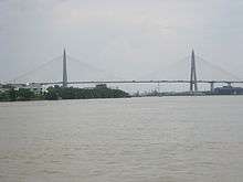 | |
| Cambodia | ||
| Indonesia | ||
| Malaysia | ||
| Philippines | ||
| Thailand | ||
| Vietnam |
| |
Cable-stayed bridges by country | ||