Bãi Cháy Bridge
| Bai Chay Bridge Cầu Bãi Cháy | |
|---|---|
 Bai Chay Bridge's main span | |
| Coordinates | 20°57′37″N 107°03′57″E / 20.9603°N 107.0658°ECoordinates: 20°57′37″N 107°03′57″E / 20.9603°N 107.0658°E |
| Carries | 4 lanes (cable-stayed section) and 6 lanes (other sections), 2 lanes each way and 2 pedestrian lanes |
| Crosses | Hạ Long Bay |
| Locale |
Quảng Ninh Province, |
| Maintained by | Ministry of Transport of Vietnam |
| Characteristics | |
| Design | Cable-stayed bridge |
| Total length | 1,106 meters (3,629 ft) |
| Width | 25 meters (82 ft) |
| Height | 150 meters (490 ft) |
| Longest span | 435 meters (1,427 ft) |
| Clearance below | 50 meters (160 ft) |
| History | |
| Constructed by |
Shimizu Sumitomo Mitsui Construction |
| Construction start | May 18, 2003 |
| Opened | December 2, 2006 |
The Bãi Cháy Bridge (Vietnamese: Cầu Bãi Cháy) is a cable-stayed bridge on Highway 18, connecting Hồng Gai with Bãi Cháy over the Cửa Lục Straits, separating Cửa Lục Bay with Hạ Long Bay, the territory of Quảng Ninh Province, Vietnam. Bãi Cháy Bridge was the first central-line cable-stayed bridge in Vietnam. At the time of its inauguration, it set a record as the longest central-line span of cable-stayed bridge.
Design
The bridge has two outer span of reinforced pre-stressed concrete box beams which are the widest of the world for this type of bridge. The towers are located on a huge pneumatic caisson foundation system, a modern construction technology first applied in Vietnam on this project. The bridge was constructed using a balanced cantilever technology, wherein the bridge beams reaching out over the water and the aligned ends connect at a head height of 50 metres (160 ft) above the water level. This technique assured that vessels could still operate normally during the construction process.
The work was completed and opened to traffic on December 2, 2006. Bãi Cháy Bridge was built to address the needs of the people of Quảng Ninh, tourists inside and outside Vietnam, and also to end decades of operation of the Bãi Cháy ferry.
Technical details
- Spans: 5 spans, main span of 435 meters (1,427 ft)
- Navigable width: 150 meters (490 ft)
- Load: Class A standard Japanese
- Cost: about VND 1046 billions, 40-month construction period, to November 30, 2006 termination
- Owner: Ministry of Transport, representing the owner: Project Management Unit 18-PMU18
- Design consultant - Monitor: Institute of bridges and structures in Japan
- Construction Contractor: Shimizu-Sumitomo Mitsui Construction
Gallery
 Bãi Cháy Bridge view from afar
 The bridge during construction
 Bãi Cháy Bridge at night
See also
References
Coordinates: 20°57′37″N 107°03′57″E / 20.96028°N 107.06583°E
Cable-stayed bridges in Southeast Asia | ||
|---|---|---|
| Brunei | 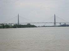 | |
| Cambodia | ||
| Indonesia | ||
| Malaysia | ||
| Philippines | ||
| Thailand | ||
| Vietnam |
| |
Cable-stayed bridges by country | ||