Newcastle, Utah
| Newcastle, Utah | |
|---|---|
| Census-designated place | |
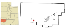 Location in Iron County and the state of Utah | |
| Coordinates: 37°39′51″N 113°33′33″W / 37.66417°N 113.55917°WCoordinates: 37°39′51″N 113°33′33″W / 37.66417°N 113.55917°W | |
| Country | United States |
| State | Utah |
| County | Iron |
| Newcastle | 1910 |
| Area | |
| • Total | 4.0 sq mi (10.3 km2) |
| • Land | 4.0 sq mi (10.3 km2) |
| • Water | 0.0 sq mi (0.0 km2) |
| Elevation[1] | 5,276 ft (1,608 m) |
| Population (2010)[2] | |
| • Total | 247 |
| • Density | 62/sq mi (24/km2) |
| Time zone | UTC-7 (Mountain (MST)) |
| • Summer (DST) | UTC-6 (MDT) |
| ZIP code | 84756 |
| Area code(s) | 435 |
| FIPS code | 49-54330 |
| GNIS feature ID | 2629952[1] |
Newcastle (also New Castle) is an unincorporated community and census-designated place (CDP) in southwestern Iron County, Utah, United States. It lies along State Route 56, 30 miles (48 km) west of Cedar City.[3] Its elevation is 5,312 feet (1,619 m) above sea level.[1] Newcastle has a post office with the ZIP code of 84756.[4] The population was 247 at the 2010 census.[5] Newcastle was founded in 1910 by citizens of the more isolated Pinto.
The predominant religion is the Church of Jesus Christ of Latter-day Saints, which church's members settled the area.
Newcastle is a small farming community which has a dairy, orchard, greenhouses producing house plants and tomatoes, and several fields. Crops produced include wheat, oats, alfalfa, corn and potatoes.
Demographics
The 2010 census reported 247 people and 92 housing units in the CDP. The 2010 census reported racial makeup was 88.7% White, 0.4% American Indian and Alaska Native, and 10.9% other races. Hispanic or Latino heritage comprised 19.0% of the population.[2]
Climate
According to the Köppen Climate Classification system, Newcastle has a semi-arid climate, abbreviated "BSk" on climate maps.[6]
See also
References
- 1 2 3 "Newcastle, Utah". Geographic Names Information System. United States Geological Survey. Retrieved May 23, 2011.
- 1 2 "American FactFinder". United States Census Bureau. Retrieved May 23, 2011.
- ↑ Rand McNally. The Road Atlas '08. Chicago: Rand McNally, 2008, p. 102.
- ↑ Zip Code Lookup
- ↑ "Geographic Identifiers: 2010 Census Summary File 1 (G001): Newcastle CDP, Utah". American Factfinder. U.S. Census Bureau. Retrieved April 13, 2018.
- ↑ Climate Summary for Newcastle, Utah
External links
![]()
Municipalities and communities of Iron County, Utah, United States | ||
|---|---|---|
| Cities | 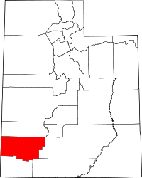 | |
| Towns | ||
| CDPs | ||
| Unincorporated communities | ||
| Ghost town | ||
| Indian reservation | ||
| Footnotes | ‡This populated place also has portions in an adjacent county or counties | |