New Oxford Formation
| New Oxford Formation Stratigraphic range: Upper Triassic | |
|---|---|
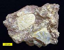 Conglomerate of the New Oxford Formation from York County, Pennsylvania | |
| Type | sedimentary |
| Unit of | Newark Supergroup |
| Underlies | Gettysburg Formation |
| Thickness | 6900 feet[1] |
| Lithology | |
| Primary | shale, sandstone |
| Other | conglomerate |
| Location | |
| Extent | Pennsylvania, Maryland |
| Type section | |
| Named by | Stose and Bascom, 1929[1] |
The New Oxford Formation is a mapped bedrock unit consisting primarily of sandstones, conglomerates, and shales. The New Oxford Formation was first described in Adams County, Pennsylvania in 1929,[1] and over the following decade was mapped in adjacent York County, Pennsylvania[2] and Frederick County, Maryland.[3] It was described as "red shale and sandstone with beds of micaceous sandstone, arkose, and conglomerate." The majority of this early mapping was done by G. W. Stose, A. I. Jonas, and Florence Bascom.
Depositional Environment
The New Oxford Formation and other formations of the Newark Supergroup were deposited in the Gettysburg Basin, just one of many Triassic rift basins existing on the east coast of North and South America, which formed as plate tectonics pulled apart Pangaea into the continents we see today.
Stratigraphy
The New Oxford Formation is overlain by the Gettysburg Formation in Frederick County, Maryland and in Adams, Cumberland, Lancaster, and York Counties in Pennsylvania. In all other areas to the northeast in Pennsylvania the New Oxford Formation is overlain by the Hammer Creek Formation.[4]
The New Oxford Formation overlies precambrian and paleozoic rocks at the bottom of the Gettysburg Basin.
The New Oxford Formation is not divided into members.
Vertebrate fauna
The New Oxford Formation contains dinosaur fossils.[5]
| Dinosaurs of the New Oxford Formation | ||||||
|---|---|---|---|---|---|---|
| Genus | Species | Location | Stratigraphic position | Material | Notes | Images |
|
Palaeosaurus fraserianus[5] |
"Tooth."[6] |
| ||||
|
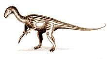
Thecodontosaurus gibbidens[5] |
"Teeth."[7] |
|||||
Age
Relative age dating of the New Oxford Formation places it in the Late Triassic period.
See also
References
- 1 2 3 Stose, G.W., and Bascom, Florence, 1929, Description of the Fairfield and Gettysburg quadrangles [Pennsylvania]: U.S. Geological Survey Geologic Atlas of the United States, Fairfield-Gettysburg folio, no. 225, 22 p.
- ↑ Stose, G.W., and Jonas, A.I., 1939, Geology and mineral resources of York County, Pennsylvania: Pennsylvania Geological Survey County Report, 4th series, no. 67, 199 p.
- ↑ Jonas, A.I., and Stose, G.W., 1938, Geologic map of Frederick County and adjacent parts of Washington and Carroll Counties (Maryland): Maryland Geological Survey County Geologic Map, 1 sheet, scale 1:62,500
- ↑ Wood, C. R., 1980, Groundwater resources of the Gettysburg and Hammer Creek Formations, southeastern Pennsylvania: Pennsylvania Geological Survey, 4th ser., Water Resource Report 49, 87 p. (see W 49).
- 1 2 3 4 5 Weishampel, David B; et al. (2004). "Dinosaur distribution (Late Triassic, North America)." In: Weishampel, David B.; Dodson, Peter; and Osmólska, Halszka (eds.): The Dinosauria, 2nd, Berkeley: University of California Press. Pp. 518–521. ISBN 0-520-24209-2.
- ↑ "Table 12.1," in Weishampel, et al. (2004). Page 236.
- ↑ "Table 14.1," in Weishampel, et al. (2004). Page 326.