New Hampshire Route 31
| ||||
|---|---|---|---|---|
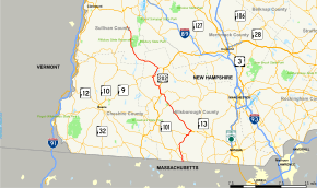 Map of southern New Hampshire with NH 31 highlighted in red | ||||
| Route information | ||||
| Maintained by NHDOT | ||||
| Length | 56.148 mi[1] (90.361 km) | |||
| Major junctions | ||||
| South end |
| |||
| ||||
| North end |
| |||
| Location | ||||
| Counties | Hillsborough, Sullivan | |||
| Highway system | ||||
| ||||

New Hampshire Route 31 (abbreviated NH 31) is a 56.148-mile-long (90.361 km) north–south state highway in southern New Hampshire. It runs from Mason on the Massachusetts border to Goshen.
The southern terminus of NH 31 is in Mason at the Massachusetts state line, where, as Greenville Road, the road becomes Massachusetts Route 31. The northern terminus of NH 31 is in Goshen at New Hampshire Route 10.
Route description
NH 31 intersects New Hampshire Route 124 within 500 yards (460 m) of the Massachusetts border. It passes through Greenville, Wilton, Lyndeborough, Greenfield, Bennington, Antrim, Hillsborough, Windsor, and Washington on its way to Goshen.
NH 31 runs concurrent with New Hampshire Route 9 for a distance of approximately 3.7 miles (6.0 km) where it passes on the west side of Franklin Pierce Lake in the town of Hillsborough. In other places, the road merges with U.S. Route 202 and New Hampshire Route 101 for a distance.
Junction list
| County | Location[1][2] | mi[1][2] | km | Destinations | Notes |
|---|---|---|---|---|---|
| Hillsborough | Mason | 0.000 | 0.000 | Continuation from Massachusetts | |
| 0.575 | 0.925 | ||||
| Greenville | 3.351 | 5.393 | Southern end of concurrency with NH 123 | ||
| 3.619 | 5.824 | Northern end of concurrency with NH 123 | |||
| Wilton | 9.321 | 15.001 | Southern end of concurrency with NH 101 | ||
| 11.315 | 18.210 | Northern end of concurrency with NH 101 | |||
| Greenfield | 22.245 | 35.800 | Southern end of concurrency with NH 136 | ||
| 22.302 | 35.892 | Northern end of concurrency with NH 136 | |||
| Bennington | 27.374 | 44.054 | Western terminus of NH 47 | ||
| 27.700 | 44.579 | Southern end of concurrency with US 202 | |||
| Antrim | 29.989 | 48.263 | Northern end of concurrency with US 202 | ||
| 34.291 | 55.186 | Southern end of concurrency with NH 9 | |||
| Hillsborough | 37.993 | 61.144 | Northern end of concurrency with NH 9 | ||
| Sullivan | Goshen | 56.148 | 90.361 | Northern terminus | |
1.000 mi = 1.609 km; 1.000 km = 0.621 mi
| |||||
Local road names
Route 31 uses the following names as it passes through different towns:
- Mason
- Greenville Road
- Greenville
- Fitchburg Road
- Wilton
- Greenville Road
- Gibbons Highway (concurrency with NH 101)
- Island Street
- Burns Hill Road
- Forest Road
- Lyndeborough
- Forest Road
- Greenfield
- Forest Road
- Sawmill Road
- Bennington
- Greenfield Road
- School Street
- Pierce Road
- Hancock Road
- concurrency with U.S. Route 202
- Antrim
- Main Street (concurrency with US-202)
- Clinton Road
- Old North Branch Road
- Franklin Pierce Highway (concurrency with NH 9)
- Hillsborough
- Franklin Pierce Highway (concurrency with NH 9)
- Second New Hampshire Turnpike
- Windsor
- Second New Hampshire Turnpike
- Washington
- Main Street
- Goshen
- Washington Road
- Mill Village Road
References
- 1 2 3 Bureau of Planning & Community Assistance (February 20, 2015). "NH Public Roads". Concord, New Hampshire: New Hampshire Department of Transportation. Retrieved April 7, 2015.
- 1 2 Bureau of Planning & Community Assistance (April 3, 2015). "Nodal Reference 2015, State of New Hampshire". New Hampshire Department of Transportation. Retrieved April 7, 2015.
- Town of Mason, Hillsborough County
- Town of Greenville, Hillsborough County
- Town of Wilton, Hillsborough County
- Town of Greenfield, Hillsborough County
- Town of Bennington, Hillsborough County
- Town of Antrim, Hillsborough County
- Town of Hillsborough, Hillsborough County
- Town of Goshen, Sullivan County