New Hampshire Route 132
| |||||||
|---|---|---|---|---|---|---|---|
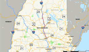 Map of central New Hampshire with NH 132 highlighted in red | |||||||
| Route information | |||||||
| Maintained by NHDOT | |||||||
| Length | 40.012 mi[1] (64.393 km) | ||||||
| Major junctions | |||||||
| South end |
| ||||||
| North end |
| ||||||
| Location | |||||||
| Counties | Merrimack, Belknap, Grafton | ||||||
| Highway system | |||||||
| |||||||

New Hampshire Route 132 (abbreviated NH 132) is a 40.012-mile-long (64.393 km) north–south highway in Belknap and Merrimack counties in central New Hampshire. NH 132 runs from Concord north to Ashland in the Lakes Region, parallel to Interstate 93.
The southern terminus of NH 132 is at New Hampshire Route 9 near Concord Municipal Airport. The northern terminus of NH 132 is at U.S. Route 3 and New Hampshire Route 25 in Ashland.
History

NH 132 was once known as New Hampshire Route 3B.
Major intersections
| County | Location[1][2] | mi[1][2] | km | Destinations | Notes |
|---|---|---|---|---|---|
| Merrimack | Concord | 0.000 | 0.000 | Southern terminus | |
| 0.435– 0.618 | 0.700– 0.995 | Exit 2 on I-393 / US 4 / US 202 | |||
| 2.302– 2.343 | 3.705– 3.771 | Exit 16 on I-93 / US 4 | |||
| 6.351 | 10.221 | Hoit Road to | Exit 17 on I-93 | ||
| Canterbury | 10.791 | 17.366 | West Road to | Exit 18 on I-93 | |
| Northfield | 16.822– 17.031 | 27.072– 27.409 | Exit 19 on I-93 north | ||
| Belknap | Tilton | 17.932 | 28.859 | Southern end of concurrency with US 3 / NH 11 | |
| 19.210– 19.593 | 30.915– 31.532 | Exit 20 on I-93 Western terminus of NH 140 | |||
| 19.685 | 31.680 | Northern end of concurrency with US 3 / NH 11 | |||
| Sanbornton | 24.890 | 40.057 | Northern terminus of NH 127 | ||
| New Hampton | 32.371 | 52.096 | Southern end of concurrency with NH 104 | ||
| 33.137– 33.360 | 53.329– 53.688 | Exit 23 on I-93 | |||
| 33.749 | 54.314 | Northern end of concurrency with NH 104 | |||
| Grafton | Ashland | 40.012 | 64.393 | Northern terminus | |
1.000 mi = 1.609 km; 1.000 km = 0.621 mi
| |||||
References
- 1 2 3 Bureau of Planning & Community Assistance (February 20, 2015). "NH Public Roads". Concord, New Hampshire: New Hampshire Department of Transportation. Retrieved April 7, 2015.
- 1 2 Bureau of Planning & Community Assistance (April 3, 2015). "Nodal Reference 2015, State of New Hampshire". New Hampshire Department of Transportation. Retrieved April 7, 2015.
External links
This article is issued from
Wikipedia.
The text is licensed under Creative Commons - Attribution - Sharealike.
Additional terms may apply for the media files.