Neuquén Basin
| Neuquén Basin | |
|---|---|
| Cuenca Neuquina | |
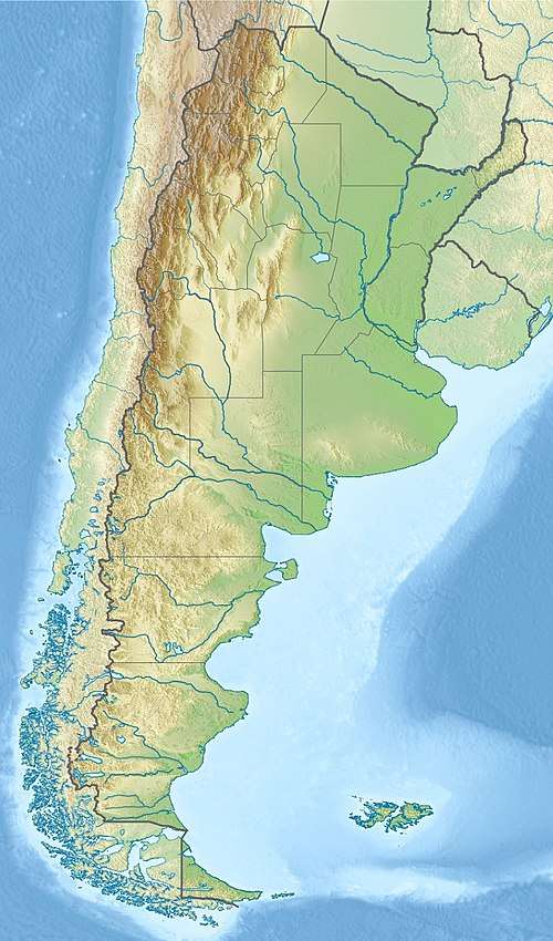 | |
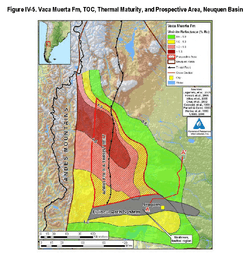 Map of Vaca Muerta showing the extend of the Neuquén Basin. Colors indicate hydrocarbon maturity as measured by vitrinite reflectance. Huincul Fault is shown in grey. | |
| Coordinates | 38°14′S 69°16′W / 38.233°S 69.267°W |
| Etymology | Neuquén Province |
| Location | Southern South America |
| Country |
|
| State(s) | Neuquén Province |
| Cities | Neuquén, Bariloche |
| Characteristics | |
| On/Offshore | Onshore |
| Boundaries |
Andean Volcanic Belt (W) Sierra Pintada (N) North Patagonian Massif (SE) |
| Part of | Andean foreland basins |
| Area | 120,000 km2 (46,000 sq mi) |
| Hydrology | |
| River(s) | Río Negro, Colorado |
| Lake(s) | Ezquiel Ramos Mexía, Los Barreales & Mari Menuco Reservoirs |
| Geology | |
| Basin type | Foreland basin |
| Plate | South American |
| Orogeny | Andean |
| Age | Triassic-Holocene |
| Stratigraphy | Stratigraphy |
| Faults | Huincul |
Neuquén Basin (Spanish: Cuenca Neuquina) is a sedimentary basin covering most of Neuquén Province in Argentina. The basin originated in the Jurassic and developed through alternating continental and marine conditions well into the Tertiary. The basin bounds to the west with the Andean Volcanic Belt, to the southeast with the North Patagonian Massif and to the northeast with the Sierra Pintada System.[1] The basin covers an area of approximately 120,000 square kilometres (46,000 sq mi).[2]
Description
Jurassic and Cretaceous marine transgressions from the Pacific are recorded in the sediments of Neuquén Basin. These marine sediments belong to Cuyo Group, Tordillo Formation, Auquilco Formation and Vaca Muerta.[3] In the Late Cretaceous, conditions in the neighboring Andean orogeny changed. A marine regression occurred and the fold and thrust belts of Malargüe (36°00 S), Chos Malal (37° S) and Agrio (38° S) started to develop in the Andes and did so until Eocene times. This meant an advance of the Andean orogenic deformation since the Late Cretaceous that made the western part of Neuquén Basin to stack in the Malargüe and Agrio fold and thrust belts.[3][4] This caused a shift in deposition from Pacific to Early Atlantic.[5]
In the south of Mendoza Province, the Guañacos fold and thrust belt (36.5° S) appeared and grew in the Pliocene and Pleistocene consuming the western fringes of the Neuquén Basin.[3][4]
Tectonics
The Huincul basement high or Huincul ridge (Spanish: dorsal de Huincul) is a geological structure that divides Neuquén Basin in two parts.[6][7] The basement high is one of the most studied features of Neuquén Basin given its importance for hydrocarbon exploration and exploitation.[7] All over the basement high runs an approximate length of 250 kilometres (160 mi).[7] There have been proposals on the nature of this structure. In the 1970s and 1980s it was proposed by that it was a transpressive fault zone.[6][7] Later Pángaro described it as being made up of inverted half-grabens.[7]
Unconformities have been registered in the basin and were dated at 98, 117, 123, 129, 134 and 154 Ma.[8]
Stratigraphy
The basin contains stratigraphic units from the Triassic onwards, with lateral variations assigned as different formations:
- Cenozoic
- Río Negro Formation
- Collón Cura Formation (Colloncuran)
- Chichinales Formation (Colhuehuapian)
- Chimehuín Formation
- Lolog Formation
- Auca Pan Formation
- Palaoco Formation
- Carrere Formation
- Pircala Formation
- Roca Formation (Danian)
- Loncoche Formation
- Jagüel Formation (middle to late Maastrichtian)
- Allen Formation (middle Campanian to early Maastrichtian)
- Río Colorado Subgroup (Santonian to early Campanian)
- Anacleto Formation (early Campanian)
- Bajo de la Carpa Formation (Santonian)
- Río Neuquén Subgroup (late Turonian to Coniacian)
- Plottier Formation (late Coniacian ?to early Santonian)
- Portezuelo Formation (late Turonian to early Coniacian)
- Río Limay Subgroup (Cenomanian to early Turonian)
- Lisandro Formation (late Cenomanian to early Turonian)
- Huincul Formation (late Cenomanian)
- Candeleros Formation (early Cenomanian)
- Lohan Cura Formation (Late Aptian to Albian)
- Rayoso Group
- Carrín Cura Formation
- Rayoso Formation (Aptian)
- Huitrín Formation
- La Amarga Formation (Barremian to early Aptian)
- Centenario Formation
- Mendoza Group
- Agrio Formation
- Bajada Colorada Formation
- Loma Montosa Formation
- Mulichinco Formation
- Quintuco Formation
- Picún Leufú Formation
- Chachao Formation
- Lindero de Piedra Formation
- Vaca Muerta (Tithonian to Berriasian)
- Puesto González Formation
- Quebrada del Sapo Formation
- Catriel Formation
- Tordillo Formation
- Auquilco Formation
- Lotena Group
- Fortín Primero de Mayo Formation
- La Manga Formation
- Lotena Formation (Callovian to Oxfordian)
- Cuyo Group
- Chailaco Formation
- Tabanos Formation
- Punta Rosada Formation
- Niyeu–Lajas Formation
- Los Molles Formation (Pliensbachian to Callovian)
- Lajoa Formation
- Lapa Formation
- Paso Flores Formation
- Remoredo Formation
- Chacajco Formation
- Planicie Morada Formation
- El Palque Formation
- Horcajos Formation
- Portezuelo del Cenizo Formation
- Tambillos Formation
- Vega de Los Machos Formation
Petroleum geology
The Neuquén Basin is an important oil and gas producing basin in Argentina. Production started in 1918 and accumulated to 5.84 MMBOE in 2004, representing 45% of the oil production in Argentina and 61% of its gas production.[9] The basin is also important for unconventionals, with the Vaca Muerta and Los Molles formations being major shale gas producers.
Source rock formations are predominantly the Vaca Muerta, and to a lesser extent the Agrio and Los Molles Formations. Reservoir rocks comprise the Mulichinco and Chachao Formations. Deeper reservoirs are the Lotena and Barda Negra Formations.[10] Regional seal rocks are the evaporites of the Auquilco and Huitrín Formations, with local seals the Vaca Muerta, Agrio and Catriel Formations.[11]
References
- ↑ "Cuenca Neuquina". Secretaría de Energía (in Spanish). Government of Argentina. Retrieved 30 November 2015.
- ↑ Howell et al., 2005
- 1 2 3 Rojas et al., 2016
- 1 2 Ramos & Mahlburg Kay, 2006
- ↑ Ponce et al., 2015, p.10
- 1 2 Mosquera & Ramos, 2006
- 1 2 3 4 5 Pángaro et al., 2009
- ↑ Leanza, 2017, p.150
- ↑ Mendiberri et al., 2004, p.1
- ↑ Ponce et al., 2015, p.28
- ↑ Ponce et al., 2015, p.29
Bibliography
- Howell, John A.; Ernesto Schwartz; Luis A. Spalletti, and Gonzalo D. Veiga. 2005. The Neuquén Basin: An overview. Geological Society, London, Special Publications 252. 1-14. Accessed 2017-06-23.
- Leanza, Héctor A. 2017. Las principales discordancias del Jurásico Superior y el Cretácico de la Cuenca Neuquina. Anales de la Academia Nacional de Ciencias Exactas, Fisicas y Naturales 57. 147–155. Accessed 2018-09-06.
- Mendiberri, Héctor O.; Adolfo E. Giusano, and Alex H. Valdéz. 2004. Cuenca Neuquína, reservas y recursos hidrocarburíferos, 1–9. _. Accessed 2018-09-06.
- Mosquera, Alfonso, and Víctor A. Ramos. 2006. Intraplate Deformation in the Neuquén Embayment. Geological Society of America Special Papers 407. 97-123.
- Ottone, Eduardo G. 2009. La flora cretácica de Cuenca Neuquina, su significado paleoambiental y paleoclimático. Revista de la Asociación Geológica Argentina 65. 373–386. Accessed 2018-09-08.
- Pángaro, Francisco; Diego Martín Pereira, and Eduardo Micucci. 2009. El sinrift de la dorsal de Huincul, Cuenca Neuquina: evolución y control sobre la estratigrafía y estructura del área. Revista de la Asociación Geológica Argentina 65. _. Accessed 2017-06-23.
- Ponce, Juan José; Aldo Omar Montagna, and Noelia Carmona. 2015. Geología de la Cuenca Neuquina y sus sistemas petroleros: una mirada integradora desde los afloramientos al subsuelo, 1–152. Fundación YPF & Universidad Nacional de Río Negro. Accessed 2018-09-06.
- Ramos, Víctor A., and Suzanne Mahlburg Kay. 2006. Evolution of an Andean Margin: A Tectonic and Magmatic View from the Andes to the Neuquén Basin (35–39°S lat). Special Paper of the Geological Society of America 407. 1–17. Accessed 2018-09-06.
- Rojas Vera, Emilio Agustín; Darío L. Orts; Andrés Folguera; Gonzalo Zamora Valcarce; Germán Bottesi; Lucas Fennell; Francisco Chiachiarelli, and Víctor A. Ramos. 2016. The Transitional Zone Between the Southern Central and Northern Patagonian Andes (36–39°S) in Growth of the Southern Andes, ed. by Andrés Folguera, Maximiliano Naipauer, Lucía Sagripanti, Matías C. Ghiglione, Darío L. Orts, and Laura Giambiagi, 99–114. Springer. Accessed 2018-09-06. ISBN 978-3-319-23060-3
Further reading
- Bally, A.W., and S. Snelson. 1980. Realms of subsidence. Canadian Society for Petroleum Geology Memoir 6. 9-94.
- Kingston, D.R.; C.P. Dishroon, and P.A. Williams. 1983. Global Basin Classification System. AAPG Bulletin 67. 2175-2193. Accessed 2017-06-23.
- Klemme, H.D. 1980. Petroleum Basins - Classifications and Characteristics. Journal of Petroleum Geology 3. 187-207. Accessed 2017-06-23.
Major South American geological features | |||||
|---|---|---|---|---|---|
| Tectonic plates |  | ||||
| Cratons and shields | |||||
| Structures undergoing subduction | |||||
| Faults and shear zones | |||||
| Rifts and grabens |
| ||||
| Sedimentary basins |
| ||||
| Orogenies |
| ||||
| Metallogenetic provinces | |||||
| Volcanism |
| ||||
Sedimentary basins of Argentina | ||||||
|---|---|---|---|---|---|---|
| Onshore |
| | ||||
| Offshore |
| |||||
| Sources |
| |||||