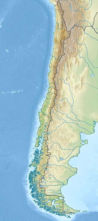
Magallanes Basin
| Magallanes Basin | |
|---|---|
| Austral Basin | |
 | |
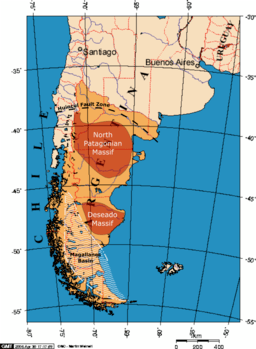 The main geologic structures comprising the region of Patagonia, including the two basement massifs of Somún Cura and Deseado. Locations of structures based on Pankhurst et al. (2006) & Ramos (2008) | |
| Coordinates | 53°00′S 69°30′W / 53.000°S 69.500°W |
| Etymology |
Strait of Magellan Austral = "south" |
| Location | Southern South America |
| Region | Patagonia |
| Country |
|
| State(s) |
Santa Cruz Province Aysén & Magallanes Regions |
| Cities |
Punta Arenas Ushuaia |
| Characteristics | |
| On/Offshore | Both |
| Boundaries | Andes, Río Chico-Dungeness High |
| Part of | Andean foreland basins |
| Area | 170,000–200,000 km2 (66,000–77,000 sq mi) |
| Hydrology | |
| Sea(s) | Southern Atlantic Ocean |
| River(s) | Shehuén River |
| Lake(s) | Viedma, Cardiel, Argentino, Pueyrredón, Fontana |
| Geology | |
| Basin type | Foreland basin |
| Orogeny | Andean |
| Age | Jurassic-Holocene |
| Stratigraphy | Stratigraphy |
| Field(s) | Chilean coal |
The Magallanes Basin or Austral Basin is a major sedimentary basin in southern Patagonia. The basin covers a surface of about 170,000 to 200,000 square kilometres (66,000 to 77,000 sq mi) and has a NNW-SSE oriented shape.[1][2] The basin is bounded to the west by the Andes mountains and is separated from the Malvinas Basin to the east by the Río Chico-Dungeness High.[1] The basin evolved from being an extensional back-arc basin in the Mesozoic to being a compressional foreland basin in the Cenozoic.[3] Rocks within the basin are Jurassic in age and include the Cerro Toro formation.[4]
The Magallanes Basin contains most of Chile's coal reserves dwarfing those found in the Arauco Basin or around Valdivia (e.g. Catamutún, Mulpún). Its coals are lignitic to sub-bituminous.[5]
Stratigraphy
Aysén Basin
The northwesternmost reaches of the basin form a sub-basin known as Aysén Basin or Río Mayo Embayment. From top to bottom the fill the basin is:[6]
- Río Frías Formation (Friasian)
- Río Baguales Formation (Deseadan)
- Late Cretaceous volcanic rock
- Divisadero Group (Aptian to Albian)
- Coihaique Group (Late Jurassic to Aptian)
- Ibañéz Formation
Northwestern basin
In the Argentinian parts of the basin, the following formations have been registered from north to south:[7]
- Santa Cruz Formation (Santacrucian)
- Cerro Boleadoras Formation (Santacrucian)
- Río Jeinemeni Formation (Colhuehuapian)
- Monte León Formation (Deseadan to Colhuehuapian)
- San Julián Formation
- Campo Bola Formation
- Asunción Formation
- Cardiel Formation (Maastrichtian)
- Mata Amarilla Formation (Albian to Santonian)
- Piedra Clavada Formation
- Kachaike Formation
- Río Tarde Formation
- Apeleg Formation
- Cerro Toro Formation
- Divisadero Group (Aptian to Albian)
- Río Belgrano Formation (Barremian to Aptian)
- Springhill Formation
- El Tranquilo Group (Late Triassic)
South-central basin
- La Ensenada Formation (Ensenadan)
- Cordillera Chica Formation
- Pinturas Formation (Santacrucian)
- Santa Cruz Formation (Santacrucian)
- Centinela Formation
- Río Leona Formation
- Río Guillero Formation
- Man Aike Formation
- Río Turbio Formation
- Calafate Formation
- Cerro Dorotea Formation
- Chorrillo Formation (Maastrichtian)
- Monte Chico Formation
- Anita Formation
- Cerro Fortaleza Formation (Cenomanian)
- Cerro Cazador Formation
- Alta Vista Formation
- Lago Sofía Formation
- Cerro Toro Formation
- Río Mayer Formation
- Zapata Formation (Berriasian to Hauterivian)
- Springhill Formation
- Tobífera Formation (Late Jurassic)
Tierra del Fuego
- Irigoyen Formation
- Punta Basílica Formation
- Castillo Formation
- Loreto Formation (Priabonian - Divisaderan to Tinguirirican)
- Cabo Peña Formation
- Tchat Chii Formation
- Cerro Colorado Formation
- Leticia Formation
- Punta Torcida Formation
- Arroyo Candelaria Formation
- Río Claro Formation
- Policarpo Formation
- Bahía Thetis Formation
- Cabeza de León Formation
- Arroyo Alfa Formation
- Yahgan Formation
- Beauvoir Formation
- Nueva Argentina Formation
- Lemaire Formation
- Pampa Rincón Formation
- Chon Aike Formation (Middle Jurassic to Berriasian)
See also
References
- 1 2 Gallardo, Rocío E. (2014). "Seismic sequence stratigraphy of a foreland unit inthe [sic] Magallanes-Austral Basin, Dorado Riquelme Block, Chile: Implications for deep-marine reservoirs". Latin American Journal of Sedimentology and Basin Analysis (in Spanish). Asociación Argentina de Sedimentología. 1221 (1). Retrieved 7 December 2015.
- ↑ "Cuenca Austral". Secretaría de Energía (in Spanish). Government of Argentina. Retrieved 30 November 2015.
De una superficie total de 170.000 Km2, unos 23.000 Km2 pertenecen al área costa afuera.
- ↑ Wilson, T.J. (1991). "Transition from back-arc to foreland basin development in the southernmost Andes: Stratigraphic record from the Ultima Esperanza District, Chile". Geological Society of America Bulletin. 103 (1): 98–111. doi:10.1130/0016-7606(1991)103<0098:tfbatf>2.3.co;2.
- ↑ Fosdick, Julie C. (2007). Late Miocene Exhumation of the Magallanes Basin and sub-Andean fold belt, southern Chile: New constrains from apatite U-Th/He thermochronology. Geological Society of America, Denver Annual Meeting (28–31 October 2007) Paper No. 123-15. Denver.
- ↑ Hackley, Paul C.; Warwick, Peter D.; Alfaro, Guillermo H.; Cuebas, Rosenelsy M. (2006). "World Coal Quality Inventory: Chile" (PDF). World Coal Quality Inventory: South America (Report). USGS. pp. 90–131. Retrieved February 23, 2017.
- ↑ Demant, A.; Suárez, M.; de la Cruz, R.; Bruguier, O (2010). "Early Cretaceous Surtseyan volcanoes of the Baño Nuevo Volcanic Complex (Aysén Basin, Eastern Central Patagonian Cordillera, Chile)". Geologica Acta. 8 (2): 207–219. doi:10.1344/105.000001530.
- ↑ Pérez Panera, 2010, p.52
Bibliography
- Pérez Panera, Juan Pablo. 2010. Sistemática y bioestratigrafía de los nanofósiles calcáreos del Cretácico del sudeste de la Cuenca Austral, Santa Cruz, Argentina (PhD thesis), 1–450. Universidad Nacional de La Plata.
Further reading
- Bally, A.W., and S. Snelson. 1980. Realms of subsidence. Canadian Society for Petroleum Geology Memoir 6. 9–94.
- Kingston, D.R.; C.P. Dishroon, and P.A. Williams. 1983. Global Basin Classification System. AAPG Bulletin 67. 2175–2193. Accessed 2017-06-23.
- Klemme, H.D. 1980. Petroleum Basins - Classifications and Characteristics. Journal of Petroleum Geology 3. 187–207. Accessed 2017-06-23.
- Moreno, Teresa, and Wes Gibbons. 2006. Geology of Chile, 1–396. Geological Society of London. Accessed 2018-09-06. ISBN 9781862392199
Major South American geological features | |||||
|---|---|---|---|---|---|
| Tectonic plates |  | ||||
| Cratons and shields | |||||
| Structures undergoing subduction | |||||
| Faults and shear zones | |||||
| Rifts and grabens |
| ||||
| Sedimentary basins |
| ||||
| Orogenies |
| ||||
| Metallogenetic provinces | |||||
| Volcanism |
| ||||
Sedimentary basins of Argentina | ||||||
|---|---|---|---|---|---|---|
| Onshore |
|  | ||||
| Offshore |
| |||||
| Sources |
| |||||