Nerbudda Division
| Nerbudda Division | |||||
| Division of British India | |||||
| |||||
 | |||||
 | |||||
| Capital | Hoshangabad | ||||
| History | |||||
| • | Creation of the division | 1853 | |||
| • | Independence of India | 1947 | |||
| Area | |||||
| • | 1901 | 47,609.2 km2 (18,382 sq mi) | |||
| Population | |||||
| • | 1901 | 1,785,008 | |||
| Density | 37.5 /km2 (97.1 /sq mi) | ||||
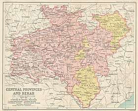
The Nerbudda Division, named after the Narmada River (Nerbudda), was a former administrative division of the Central Provinces of British India.[1] It encompassed a good part of the Narmada River basin in the eastern part of present-day Madhya Pradesh state of India. The Nerbudda Division had an area of 47,609.2 km² with a population of 1,785,008 in 1901.[2]
The Central Provinces became the Central Provinces and Berar in 1936 until the Independence of India.
Territory
The main mountains in the division were the Mahadeo Hills, the central part of the Satpura Range, where Pachmarhi, the summer hill station for British officials, and the Pachmarhi Cantonment were located.[3]
The main towns in the division were Hoshangabad (15,863 inhabitants in 1881), Burhanpur (33,341 inhabitants in 1901) and Gadarwara (6,978 in 1901); other important towns were Khandwa, Harda, Narsinghpur, Chhindwara, Pandhurna, Sohagpur, Seoni and Mohgaon.
Administrative divisions
Districts
The Nerbudda Division included the following districts:[1]
- Narsinghpur
- Hoshangabad
- Nimar, present-day Khandwa (East Nimar) and Khargone (West Nimar)
- Betul
- Chhindwara
Princely states
Makrai State was the only princely state within the division and was under the supervision of the Nerbudda commissioner.
See also
References
- 1 2

- ↑ Hunter, William Wilson, Sir, et al. (1908). Imperial Gazetteer of India, Volume 6. 1908–1931; Clarendon Press, Oxford.
- ↑ Pachmarhi, Jewel in the crown of Central India
- McEldowney, Philip F. (1980). Colonial Administration and Social Developments in middle India: The Central Provinces, 1861–1921. Ph. D. Dissertation.