Needmore, Mississippi
| Needmore, Mississippi | |
|---|---|
| Ghost town | |
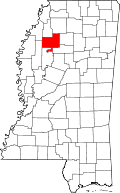
 Needmore, Mississippi Location within the state of Mississippi | |
| Coordinates: 33°52′56″N 90°10′08″W / 33.88222°N 90.16889°WCoordinates: 33°52′56″N 90°10′08″W / 33.88222°N 90.16889°W | |
| Country | United States |
| State | Mississippi |
| County | Tallahatchie |
| Elevation | 144 ft (44 m) |
| Time zone | UTC-6 (Central (CST)) |
| • Summer (DST) | UTC-5 (CDT) |
| GNIS feature ID | 708149[1] |
Needmore is a ghost town in Tallahatchie County, Mississippi, United States.
Needmore was located on the west bank of the Tippo Bayou, approximately 10 mi (16 km) southwest of Charleston.
The settlement had a post office, school, church and cemetery. The Needmore Cemetery is all that remains.[2][3][4]
References
- ↑ U.S. Geological Survey Geographic Names Information System: Needmore (historical)
- ↑ Rowland, Dunbar (1907). Mississippi: Comprising Sketches of Counties, Towns, Events, Institutions, and Persons, Arranged in Cyclopedic Form. 2. Southern Historical Publishing Association. p. 329.
- ↑ U.S. Geological Survey Geographic Names Information System: Needmore (historical)
- ↑ "Allison Oral History". Delta State University. July 17, 1980.
This article is issued from
Wikipedia.
The text is licensed under Creative Commons - Attribution - Sharealike.
Additional terms may apply for the media files.
