Crevi, Mississippi
| Crevi, Mississippi | |
|---|---|
| Ghost town | |
 Crevi, Mississippi Location within the state of Mississippi | |
| Coordinates: 34°02′45″N 90°02′55″W / 34.04583°N 90.04861°WCoordinates: 34°02′45″N 90°02′55″W / 34.04583°N 90.04861°W | |
| Country | United States |
| State | Mississippi |
| County | Tallahatchie |
| Elevation | 233 ft (71 m) |
| Time zone | UTC-6 (Central (CST)) |
| • Summer (DST) | UTC-5 (CDT) |
| GNIS feature ID | 708134[1] |
Crevi (also Mitchells Cross Roads) is a ghost town in Tallahatchie County, Mississippi, United States.
Crevi was located approximately 3 mi (4.8 km) northeast of Charleston.
In 1876, the United States government established a postal road between Crevi and Friars Point, Mississippi.[2]
Crevi had a post office, and in 1900, a population of 21.[3]
References
- ↑ U.S. Geological Survey Geographic Names Information System: Crevi (historical)
- ↑ The Statutes at Large of the United States of America, from December 1875, to March, 1877, and Recent Treaties, Postal Conventions, and Executive Proclamations. XIX. Government Printing Office. 1877. p. 18.
- ↑ Rowland, Dunbar (1907). Mississippi: Comprising Sketches of Counties, Towns, Events, Institutions, and Persons, Arranged in Cyclopedic Form. 1. Southern Historical Publishing Association. p. 589.
Municipalities and communities of Tallahatchie County, Mississippi, United States | ||
|---|---|---|
| City | 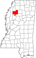 | |
| Towns | ||
| Village | ||
| Unincorporated communities | ||
| Ghost towns | ||
| Footnotes | ‡This populated place also has portions in an adjacent county or counties | |
This article is issued from
Wikipedia.
The text is licensed under Creative Commons - Attribution - Sharealike.
Additional terms may apply for the media files.