National Register of Historic Places listings in Van Wert County, Ohio
Location of Van Wert County in Ohio
This is a list of the National Register of Historic Places listings in Van Wert County, Ohio.
It is intended to be a complete list of the properties on the National Register of Historic Places in Van Wert County, Ohio, United States. The locations of National Register properties for which the latitude and longitude coordinates are included below, may be seen in a Google map.[1]
There are 6 properties listed on the National Register in the county. Another 2 properties were once listed but have been removed.
- This National Park Service list is complete through NPS recent listings posted October 11, 2018.[2]
Current listings
| [3] | Name on the Register[4] | Image | Date listed[5] | Location | City or town | Description |
|---|---|---|---|---|---|---|
| 1 | Bredeick-Lang House | 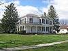 |
April 7, 1982 (#82003663) |
508 W. 2nd St. 40°50′38″N 84°20′43″W / 40.843889°N 84.345278°W |
Delphos | |
| 2 | Brumback Library | 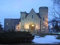 |
January 29, 1979 (#79001973) |
215 W. Main St. 40°52′13″N 84°35′06″W / 40.870139°N 84.585000°W |
Van Wert | |
| 3 | George H. Marsh Homestead and the Marsh Foundation School | 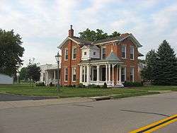 |
November 28, 1980 (#80003239) |
1229 Lincoln Highway 40°52′17″N 84°33′53″W / 40.87147°N 84.56466°W |
Van Wert | |
| 4 | Round Barn | 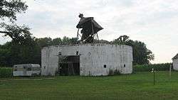 |
April 17, 1980 (#80003240) |
Off U.S. Route 224 west of Van Wert 40°51′06″N 84°45′46″W / 40.851667°N 84.762778°W |
Harrison Township | |
| 5 | Van Wert Bandstand | 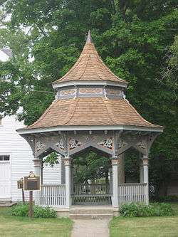 |
October 14, 1982 (#82001493) |
On the grounds of the Van Wert County Historical Museum, 602 N. Washington St.[6] 40°52′33″N 84°34′58″W / 40.875972°N 84.582806°W |
Van Wert | |
| 6 | Van Wert County Courthouse | 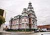 |
July 30, 1974 (#74001639) |
121 E. Main St. 40°52′12″N 84°34′55″W / 40.87°N 84.581944°W |
Van Wert |
Former listings
| [3] | Name on the Register | Image | Date listed | Date removed | Location | City or town | Summary |
|---|---|---|---|---|---|---|---|
| 1 | Lukins-Plummer House | Unavailable (#74002342) | 1999 | W of Harveysburg off Middletown Rd. |
Van Wert | ||
| 2 | Willshire School | November 25, 1980 (#80003241) | January 25, 2001 | Green St. |
Willshire |
See also
| Wikimedia Commons has media related to National Register of Historic Places in Van Wert County, Ohio. |
References
- ↑ The latitude and longitude information provided in this table was derived originally from the National Register Information System, which has been found to be fairly accurate for about 99% of listings. For about 1% of NRIS original coordinates, experience has shown that one or both coordinates are typos or otherwise extremely far off; some corrections may have been made. A more subtle problem causes many locations to be off by up to 150 yards, depending on location in the country: most NRIS coordinates were derived from tracing out latitude and longitudes from USGS topographical quadrant maps created under the North American Datum of 1927, which differs from the current, highly accurate WGS84 GPS system used by most on-line maps. Chicago is about right, but NRIS longitudes in Washington are higher by about 4.5 seconds, and are lower by about 2.0 seconds in Maine. Latitudes differ by about 1.0 second in Florida. Some locations in this table may have been corrected to current GPS standards.
- ↑ "National Register of Historic Places: Weekly List Actions". National Park Service, United States Department of the Interior. Retrieved on October 11, 2018.
- 1 2 Numbers represent an ordering by significant words. Various colorings, defined here, differentiate National Historic Landmarks and historic districts from other NRHP buildings, structures, sites or objects.
- ↑ National Park Service (2008-04-24). "National Register Information System". National Register of Historic Places. National Park Service.
- ↑ The eight-digit number below each date is the number assigned to each location in the National Register Information System database, which can be viewed by clicking the number.
- ↑ Location derived from this Van Wert County Historical Museum webpage; the NRIS lists it at its original location at the Van Wert County Fairgrounds along U.S. Route 127


Municipalities and communities of Van Wert County, Ohio, United States | ||
|---|---|---|
| Cities | | |
| Villages | ||
| Townships | ||
| Unincorporated communities | ||
| Footnotes | ‡This populated place also has portions in an adjacent county or counties | |
This article is issued from
Wikipedia.
The text is licensed under Creative Commons - Attribution - Sharealike.
Additional terms may apply for the media files.