National Register of Historic Places listings in Valley County, Nebraska
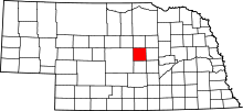
Location of Valley County in Nebraska
This is a list of the National Register of Historic Places listings in Valley County, Nebraska. It is intended to be a complete list of the properties and districts on the National Register of Historic Places in Valley County, Nebraska, United States. The locations of National Register properties and districts for which the latitude and longitude coordinates are included below, may be seen in an online map.
There are 6 properties and districts listed on the National Register in the county. Another property was once listed but has been removed
- This National Park Service list is complete through NPS recent listings posted October 11, 2018.[1]
Current listings
| [2] | Name on the Register[3] | Image | Date listed[4] | Location | City or town | Description |
|---|---|---|---|---|---|---|
| 1 | Josef and Anna Beran Bruha House | April 5, 1990 (#90000564) |
West of Elyria 41°39′48″N 99°09′52″W / 41.663230°N 99.164542°W |
Burwell | ||
| 2 | Fort Hartsuff | 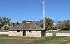 |
March 24, 1978 (#78001716) |
North of Elyria 41°43′23″N 99°01′28″W / 41.723056°N 99.024444°W |
Elyria | |
| 3 | North Loup Bridge | _from_SW_2.JPG) |
June 29, 1992 (#92000704) |
County road over the North Loup River, 1.5 miles northeast of North Loup 41°30′37″N 98°45′06″W / 41.51031°N 98.75157°W |
North Loup | |
| 4 | Rad Slavin cis. 112 Z.C.B.J. Hall | November 12, 1992 (#92001569) |
Sargent-Ord Rd. 41°36′36″N 99°09′20″W / 41.610111°N 99.1555°W |
Comstock | ||
| 5 | Schultz Site | October 15, 1966 (#66000453) |
Address Restricted |
North Loup | ||
| 6 | Valley County Courthouse | 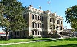 |
January 10, 1990 (#89002235) |
16th St. between L and M Sts. 41°36′09″N 98°55′42″W / 41.6025°N 98.928333°W |
Ord |
Former listing
| [2] | Name on the Register | Image | Date listed | Date removed | Location | City or town | Summary |
|---|---|---|---|---|---|---|---|
| 1 | People's Unitarian Church | _from_SW.JPG) |
June 14, 1984 (#84002497) | July 24, 2017 | 1640 N St. 41°36′05″N 98°55′48″W / 41.601389°N 98.93°W |
Ord |
See also
References
- ↑ "National Register of Historic Places: Weekly List Actions". National Park Service, United States Department of the Interior. Retrieved on October 11, 2018.
- 1 2 Numbers represent an ordering by significant words. Various colorings, defined here, differentiate National Historic Landmarks and historic districts from other NRHP buildings, structures, sites or objects.
- ↑ National Park Service (2009-03-13). "National Register Information System". National Register of Historic Places. National Park Service.
- ↑ The eight-digit number below each date is the number assigned to each location in the National Register Information System database, which can be viewed by clicking the number.
External links
| Wikimedia Commons has media related to National Register of Historic Places in Valley County, Nebraska. |
| Topics | |
|---|---|
| Lists by states |
|
| Lists by insular areas | |
| Lists by associated states | |
| Other areas | |
| |
Municipalities and communities of Valley County, Nebraska, United States | ||
|---|---|---|
| City | ||
| Villages | ||
| Townships | ||
| Unincorporated communities | ||
| Ghost towns | ||
This article is issued from
Wikipedia.
The text is licensed under Creative Commons - Attribution - Sharealike.
Additional terms may apply for the media files.