National Register of Historic Places listings in Red Willow County, Nebraska
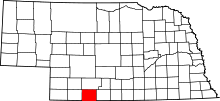
Location of Red Willow County in Nebraska
This is a list of the National Register of Historic Places listings in Red Willow County, Nebraska.
This is intended to be a complete list of the properties and districts on the National Register of Historic Places in Red Willow County, Nebraska, United States. The locations of National Register properties and districts for which the latitude and longitude coordinates are included below, may be seen in a map.[1]
There are 9 properties and districts listed on the National Register in the county, including 1 National Historic Landmark.
- This National Park Service list is complete through NPS recent listings posted October 11, 2018.[2]
Current listings
Bartley Sales Barn, SW. corner of US 6/34 & Commercial St., Bartley, RS100001356, LISTED, 6/25/2018
| [3] | Name on the Register[4] | Image | Date listed[5] | Location | City or town | Description |
|---|---|---|---|---|---|---|
| 1 | Bartley Sales Barn | June 25, 2018 (#100001356) |
SW. corner of US 6/34 & Commercial St. 40°15′03″N 100°18′22″W / 40.250835°N 100.306105°W |
Bartley | ||
| 2 | Doyle Archeological Site | December 4, 1974 (#74001138) |
Address Restricted |
McCook | ||
| 3 | Keystone Hotel | _from_NE_1.JPG) |
July 5, 2001 (#01000710) |
402 Norris Ave. 40°12′21″N 100°37′55″W / 40.205833°N 100.631944°W |
McCook | |
| 4 | McCook Public-Carnegie Library | 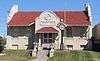 |
September 12, 1985 (#85002142) |
423 Norris Ave. 40°12′05″N 100°37′31″W / 40.201389°N 100.625278°W |
McCook | |
| 5 | McCook YMCA | _from_NE_2.JPG) |
March 9, 2000 (#00000167) |
424 Norris Ave. 40°12′06″N 100°37′33″W / 40.201667°N 100.625833°W |
McCook | |
| 6 | Senator George William Norris House | 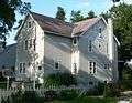 |
May 28, 1967 (#67000006) |
706 Norris Ave. 40°12′15″N 100°37′32″W / 40.204167°N 100.625556°W |
McCook | |
| 7 | Red Willow County Courthouse | 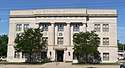 |
July 5, 1990 (#90000966) |
Northwestern corner of Norris Ave. and East E St. 40°12′07″N 100°37′32″W / 40.201944°N 100.625556°W |
McCook | part of the County Courthouses of Nebraska Multiple Property Submission |
| 8 | Second-Generation Norden Bombsight Vault | June 17, 1993 (#93000534) |
Off U.S. Route 83 northwest of McCook at the former McCook Army Air Base 40°18′29″N 100°42′13″W / 40.308056°N 100.703611°W |
McCook | part of the Significant Relic Components of US Army Air Fields in Nebraska Multiple Property Submission | |
| 9 | H.P. Stutton House | _from_SE_3.JPG) |
May 22, 1978 (#78001708) |
602 Norris Ave. 40°12′11″N 100°37′32″W / 40.203056°N 100.625556°W |
McCook |
See also
| Wikimedia Commons has media related to National Register of Historic Places in Red Willow County, Nebraska. |
References
- ↑ The latitude and longitude information provided in this table was derived originally from the National Register Information System, which has been found to be fairly accurate for about 99% of listings. For about 1% of NRIS original coordinates, experience has shown that one or both coordinates are typos or otherwise extremely far off; some corrections may have been made. A more subtle problem causes many locations to be off by up to 150 yards, depending on location in the country: most NRIS coordinates were derived from tracing out latitude and longitudes from USGS topographical quadrant maps created under the North American Datum of 1927, which differs from the current, highly accurate WGS84 GPS system used by most on-line maps. Chicago is about right, but NRIS longitudes in Washington are higher by about 4.5 seconds, and are lower by about 2.0 seconds in Maine. Latitudes differ by about 1.0 second in Florida. Some locations in this table may have been corrected to current GPS standards.
- ↑ "National Register of Historic Places: Weekly List Actions". National Park Service, United States Department of the Interior. Retrieved on October 11, 2018.
- ↑ Numbers represent an ordering by significant words. Various colorings, defined here, differentiate National Historic Landmarks and historic districts from other NRHP buildings, structures, sites or objects.
- ↑ National Park Service (2010-07-09). "National Register Information System". National Register of Historic Places. National Park Service.
- ↑ The eight-digit number below each date is the number assigned to each location in the National Register Information System database, which can be viewed by clicking the number.
| Topics | |
|---|---|
| Lists by states |
|
| Lists by insular areas | |
| Lists by associated states | |
| Other areas | |
| |
Municipalities and communities of Red Willow County, Nebraska, United States | ||
|---|---|---|
| Cities | ||
| Villages | ||
| Unincorporated communities | ||
This article is issued from
Wikipedia.
The text is licensed under Creative Commons - Attribution - Sharealike.
Additional terms may apply for the media files.