National Register of Historic Places listings in Putnam County, Georgia
This is a list of properties and districts in Putnam County, Georgia that are listed on the National Register of Historic Places (NRHP).
- This National Park Service list is complete through NPS recent listings posted October 4, 2018.[1]
Current listings
| [2] | Name on the Register | Image | Date listed[3] | Location | City or town | Description |
|---|---|---|---|---|---|---|
| 1 | Eatonton Historic District |  |
June 13, 1975 (#75000605) |
Most of town centered around courthouse and city hall 33°19′50″N 83°23′17″W / 33.330556°N 83.388056°W |
Eatonton | |
| 2 | Gatewood House | June 20, 1975 (#75000606) |
6 mi. NE of Eatonton off GA 44 33°23′41″N 83°18′02″W / 33.394722°N 83.300556°W |
Eatonton | ||
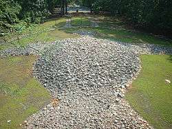
| 3 | Rock Eagle Site |  |
May 23, 1978 (#78001001) |
Address Restricted |
Eatonton | Rock Eagle Effigy Mound, 1000–3000 years old, viewable from an observation tower |
| 4 | Rockville Academy and St. Paul Methodist Church Historic District |  |
November 19, 2002 (#02001382) |
E of Eatonton and S of GA 16, Rockville Rd. 33°19′32″N 83°13′08″W / 33.325556°N 83.218889°W |
Eatonton | |
| 5 | Singleton House | October 1, 1974 (#74000701) |
SW of Eatonton off GA 16 33°18′03″N 83°29′50″W / 33.300833°N 83.497222°W |
Eatonton | ||
| 6 | Strong-Davis-Rice-George House | November 8, 2006 (#06000987) |
107 Hudson Rd. 33°19′39″N 83°23′59″W / 33.3275°N 83.399722°W |
Eatonton | ||
| 7 | Terrell-Sadler House | March 31, 2000 (#00000303) |
122 Harmony Rd. 33°25′52″N 83°22′14″W / 33.431111°N 83.370556°W |
Harmony | ||
| 8 | Tompkins Inn | October 5, 1978 (#78001002) |
N of Eatonton on U.S. 441 33°26′11″N 83°22′40″W / 33.436389°N 83.377778°W |
Eatonton | ||
| 9 | Turnwold | March 10, 1980 (#80001225) |
SE of Eatonton on Old Phoenix Rd. 33°22′43″N 83°16′29″W / 33.378611°N 83.274722°W |
Eatonton | ||
| 10 | Woodland | January 29, 1979 (#79000741) |
NE of Eatonton on Harmony Rd. 33°26′43″N 83°17′39″W / 33.445278°N 83.294167°W |
Eatonton |
References
- ↑ "National Register of Historic Places: Weekly List Actions". National Park Service, United States Department of the Interior. Retrieved on October 4, 2018.
- ↑ Numbers represent an ordering by significant words. Various colorings, defined here, differentiate National Historic Landmarks and historic districts from other NRHP buildings, structures, sites or objects.
- ↑ The eight-digit number below each date is the number assigned to each location in the National Register Information System database, which can be viewed by clicking the number.
| Wikimedia Commons has media related to National Register of Historic Places in Putnam County, Georgia. |
This article is issued from
Wikipedia.
The text is licensed under Creative Commons - Attribution - Sharealike.
Additional terms may apply for the media files.