National Register of Historic Places listings in Otoe County, Nebraska
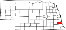
Location of Otoe County in Nebraska
This is a list of the National Register of Historic Places listings in Otoe County, Nebraska.
This is intended to be a complete list of the properties and districts on the National Register of Historic Places in Otoe County, Nebraska, United States. The locations of National Register properties and districts for which the latitude and longitude coordinates are included below, may be seen in a map.[1]
There are 27 properties and districts listed on the National Register in the county, including 1 National Historic Landmark. Another property that was once listed has been removed.
- This National Park Service list is complete through NPS recent listings posted October 11, 2018.[2]
Current listings
| [3] | Name on the Register | Image | Date listed[4] | Location | City or town | Description |
|---|---|---|---|---|---|---|
| 1 | Arbor Lodge | 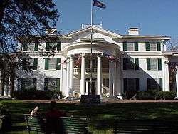 |
April 16, 1969 (#69000135) |
Arbor Lodge State Park, west of Nebraska City 40°40′49″N 95°52′42″W / 40.680278°N 95.878333°W |
Nebraska City | |
| 2 | Boscobel | _from_E_long_1.JPG) |
June 17, 1976 (#76001133) |
North of Nebraska City on Steamwagon Rd. 40°40′59″N 95°52′36″W / 40.683056°N 95.876667°W |
Nebraska City | |
| 3 | Bridge | 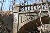 |
June 29, 1992 (#92000737) |
Unnamed stream, southwest of Nebraska City 40°41′45″N 95°53′01″W / 40.69572°N 95.88361°W |
Nebraska City | Road leading to bridge no longer exists.[5] Part of the Highway Bridges in Nebraska Multiple Property Submission (MPS). |
| 4 | Bridge | June 29, 1992 (#92000733) |
County road over an unnamed stream, 4.1 miles (6.6 km) southwest of Lorton 40°34′01″N 96°05′26″W / 40.566944°N 96.090556°W |
Lorton | ||
| 5 | Camp Creek Cemetery and Chapel | 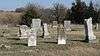 |
March 21, 2011 (#11000102) |
Northeast corner of County Road P and S. 70th Rd. 40°34′04″N 95°48′08″W / 40.567778°N 95.802222°W |
Nebraska City | |
| 6 | Camp Creek School, Otoe County District No. 54 | 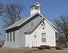 |
June 5, 1980 (#80002459) |
6903 Q Rd[6] 40°33′08″N 95°48′42″W / 40.55228°N 95.81164°W |
Nebraska City | |
| 7 | Grand Army of the Republic (G.A.R.) Memorial Hall | 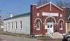 |
February 25, 1994 (#94000067) |
908 1st Corso 40°40′33″N 95°51′25″W / 40.67592°N 95.85689°W |
Nebraska City | |
| 8 | Harmony School, School District No. 53 | 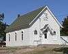 |
July 22, 2005 (#05000723) |
6265 Q Rd.[7] 40°33′09″N 95°52′20″W / 40.55239°N 95.87214°W |
Nebraska City | |
| 9 | Kregel Wind Mill Company | 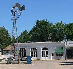 |
February 25, 1993 (#93000061) |
1416 Central Ave. 40°40′37″N 95°51′49″W / 40.676944°N 95.86361°W |
Nebraska City | Now the Kregel Windmill Factory Museum.[8] |
| 10 | George F. Lee Octagon Houses | .JPG) |
November 23, 1977 (#77000834) |
South of Nebraska City off U.S. Route 73 40°34′18″N 95°48′05″W / 40.571674°N 95.801498°W |
Nebraska City | |
| 11 | Little Nemaha River Bridge | 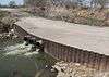 |
June 29, 1992 (#92000720) |
County road over the Little Nemaha River, 1.8 miles (2.9 km) northwest of Dunbar 40°40′58″N 96°02′43″W / 40.68264°N 96.04517°W |
Dunbar | Bridge no longer there; replaced by culvert. |
| 12 | Joachim Massow-Charles and Annie Schutz House | 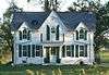 |
August 28, 2012 (#12000567) |
4250 F Rd. 40°42′39″N 96°03′34″W / 40.710704°N 96.059395°W |
Dunbar | |
| 13 | Mayhew Cabin | 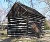 |
February 11, 2011 (#11000013) |
2012 4th Corso 40°40′24″N 95°52′12″W / 40.673333°N 95.87003°W |
Nebraska City | |
| 14 | McCartney School District 17 | _remains_1.JPG) |
November 15, 2000 (#00001379) |
5797 H Road[9] 40°40′57″N 95°55′00″W / 40.682436°N 95.916631°W |
Nebraska City | Apparently removed or demolished[10] |
| 15 | Memorial Building | 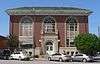 |
March 22, 2016 (#16000106) |
810 1st Corso 40°40′33″N 95°51′20″W / 40.675955°N 95.855570°W |
Nebraska City | |
| 16 | Morton-James Public Library | 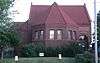 |
May 28, 1976 (#76001134) |
923 First Corso[11] 40°40′32″N 95°51′26″W / 40.675441°N 95.85736°W |
Nebraska City | |
| 17 | Nebraska City Burlington Depot | August 8, 1997 (#97000881) |
Southeast intersection of 6th Street and 7th Corso[12] 40°40′13″N 95°51′09″W / 40.67019°N 95.85256°W |
Nebraska City | ||
| 18 | Nebraska City Historic District | 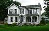 |
October 29, 1976 (#76001135) |
Roughly bounded by 5th Ave., 3rd St., 19th St., and 1st Corso 40°40′43″N 95°51′30″W / 40.678611°N 95.858333°W |
Nebraska City | |
| 19 | Otoe County Courthouse | 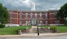 |
June 18, 1976 (#76001136) |
10th St. and Central Ave. 40°40′34″N 95°51′30″W / 40.676193°N 95.858264°W |
Nebraska City | |
| 20 | St. Benedict's Catholic Church | 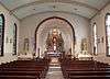 |
January 27, 1983 (#83001100) |
411 5th Rue 40°40′11″N 95°50′28″W / 40.66972°N 95.84111°W |
Nebraska City | |
| 21 | South 13th Street Historic District | 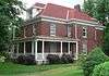 |
October 29, 1976 (#76001137) |
Roughly bounded by 12th Street, 14th Street, 1st Corso, and 6th Corso 40°40′24″N 95°51′39″W / 40.673333°N 95.860833°W |
Nebraska City | |
| 22 | South Nebraska City Historic District | 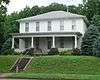 |
October 22, 1976 (#76001138) |
Roughly bounded by 4th Street, 11th Street, 1st Corso, and 4th Corso 40°40′27″N 95°51′14″W / 40.674167°N 95.853889°W |
Nebraska City | |
| 23 | U.S. Post Office | 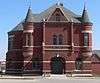 |
September 3, 1971 (#71000488) |
202 S. 8th St. 40°40′32″N 95°51′20″W / 40.67547°N 95.85542°W |
Nebraska City | Now Farmers Bank & Trust Co.[13] |
| 24 | Unadilla Main Street Historic District | 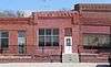 |
February 17, 1995 (#95000095) |
Northern side of Main St. between G and H Sts. 40°40′54″N 96°16′21″W / 40.68172°N 96.2726°W |
Unadilla | |
| 25 | Jasper A. Ware House | 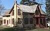 |
July 16, 1973 (#73001070) |
420 Steinhart Park Rd.[14] 40°40′18″N 95°52′50″W / 40.67157°N 95.88064°W |
Nebraska City | Operated as museum under name "Wildwood Historic Center".[14] |
| 26 | Wolf Creek Bridge | _from_N_1.JPG) |
June 29, 1992 (#92000738) |
Vacated county road over Wolf Creek, 10.3 miles (16.6 km) northeast of Dunbar 40°47′03″N 95°54′57″W / 40.78415°N 95.91576°W |
Dunbar | |
| 27 | Wyoming Bridge | 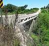 |
June 29, 1992 (#92000736) |
County road over Squaw Creek, 9.1 miles (14.6 km) northeast of Dunbar 40°44′43″N 95°53′33″W / 40.745343°N 95.892594°W |
Dunbar | Apparently replaced by beam bridge in 2003[15] |
Former listing
| [3] | Name on the Register | Image | Date listed | Date removed | Location | City or town | Summary |
|---|---|---|---|---|---|---|---|
| 1 | Little Nemaha River Bridge | June 29, 1992 (#92000723) | December 19, 2012 | County road over the Little Nemaha River, 3 miles (4.8 km) northwest of Syracuse 40°40′00″N 96°14′09″W / 40.666667°N 96.235833°W |
Syracuse |
See also
| Wikimedia Commons has media related to National Register of Historic Places in Otoe County, Nebraska. |
References
- ↑ The latitude and longitude information provided in this table was derived originally from the National Register Information System, which has been found to be fairly accurate for about 99% of listings. For about 1% of NRIS original coordinates, experience has shown that one or both coordinates are typos or otherwise extremely far off; some corrections may have been made. A more subtle problem causes many locations to be off by up to 150 yards, depending on location in the country: most NRIS coordinates were derived from tracing out latitude and longitudes from USGS topographical quadrant maps created under the North American Datum of 1927, which differs from the current, highly accurate WGS84 GPS system used by most on-line maps. Chicago is about right, but NRIS longitudes in Washington are higher by about 4.5 seconds, and are lower by about 2.0 seconds in Maine. Latitudes differ by about 1.0 second in Florida. Some locations in this table may have been corrected to current GPS standards.
- ↑ "National Register of Historic Places: Weekly List Actions". National Park Service, United States Department of the Interior. Retrieved on October 11, 2018.
- 1 2 Numbers represent an ordering by significant words. Various colorings, defined here, differentiate National Historic Landmarks and historic districts from other NRHP buildings, structures, sites or objects.
- ↑ The eight-digit number below each date is the number assigned to each location in the National Register Information System database, which can be viewed by clicking the number.
- ↑ See photo.
- ↑ See photos: this one for Q, this one for the 6903 address (lower right corner).
- ↑ "Harmony School". Otoe County Genealogical Society. Retrieved 2012-03-05.
- ↑ "Kregel Windmill Museum". Retrieved 2012-04-18.
- ↑ "Mc Cartney Public School". Nebraska Department of Education. Retrieved 2012-03-05.
- ↑ See June 2013 photos at Commons:Category:McCartney School District 17 (Otoe County, Nebraska). NRHP nominating form lists a single contributing building, a red brick schoolhouse. A basketball hoop and pump visible in photos are mentioned in the form, but no contributing structures or objects are listed. A July 14, 2009 article in the Nebraska City News-Press states that the Nebraska City School Board voted to sell the school.
- ↑ "Contact Us". Archived 2013-06-21 at the Wayback Machine. Morton-James Public Library. Retrieved 2013-06-15.
- ↑ Miller, Greg. "National Register of Historic Places Registration Form: Nebraska City Burlington Depot". Nebraska State Historical Society. Retrieved 2012-03-05.
- ↑ "Farmers Bank & Trust Co." Archived 2012-04-26 at the Wayback Machine. Retrieved 2012-04-19.
- 1 2 "Wildwood Historic Center". Retrieved 2012-03-05.
- ↑ See June 2013 photos at Commons:Category:Wyoming Creek bridge, CR 60, Otoe County, Nebraska for current bridge. According to uglybridges.com, the current bridge was built in 2003.
| Topics | |
|---|---|
| Lists by states |
|
| Lists by insular areas | |
| Lists by associated states | |
| Other areas | |
| |
Municipalities and communities of Otoe County, Nebraska, United States | ||
|---|---|---|
| Cities | ||
| Villages | ||
| CDP | ||
| Unincorporated communities | ||
| Ghost town | ||
This article is issued from
Wikipedia.
The text is licensed under Creative Commons - Attribution - Sharealike.
Additional terms may apply for the media files.