National Register of Historic Places listings in Madison County, Mississippi
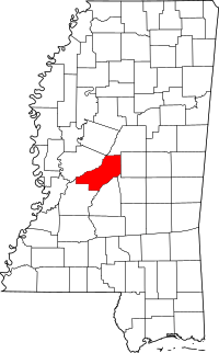
Location of Madison County in Mississippi
This is a list of the National Register of Historic Places listings in Madison County, Mississippi.
This is intended to be a complete list of the properties and districts on the National Register of Historic Places in Madison County, Mississippi, United States. Latitude and longitude coordinates are provided for many National Register properties and districts; these locations may be seen together in a map.[1]
There are 31 properties and districts listed on the National Register in the county.
- This National Park Service list is complete through NPS recent listings posted October 11, 2018.[2]
Current listings
| [3] | Name on the Register[4] | Image | Date listed[5] | Location | City or town | Description |
|---|---|---|---|---|---|---|
| 1 | John W. Boddie House | 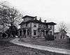 |
May 13, 1982 (#82003106) |
Tougaloo College campus 32°24′15″N 90°09′39″W / 32.4041°N 90.1607°W |
Tougaloo | |
| 2 | Boyd Mounds Site (22MD512) | 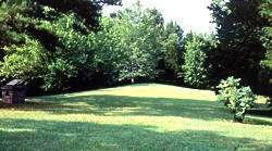 |
July 14, 1989 (#89000784) |
Mile 106.9 on the Natchez Trace Parkway[6] 32°27′13″N 90°04′05″W / 32.4535°N 90.0681°W |
Ridgeland | A six mound site that is situated next to a parking area off the Natchez Trace Parkway and is accessible to visitors.[7] |
| 3 | Canton Cemetery | January 14, 2015 (#14001155) |
S. Lyon St. 32°36′33″N 90°01′45″W / 32.6093°N 90.0292°W |
Canton | ||
| 4 | Canton Courthouse Square Historic District |  |
August 30, 1982 (#82004895) |
Center, Liberty, Peace, and Union Sts.; also W. Peace St. 32°36′46″N 90°02′07″W / 32.612778°N 90.035278°W |
Canton | W. Peace St. represents a boundary increase of June 29, 1989 |
| 5 | Canton High School |  |
November 5, 1998 (#98001334) |
3380 N. Liberty St. 32°36′58″N 90°02′03″W / 32.616111°N 90.034167°W |
Canton | |
| 6 | Chapel of the Cross | 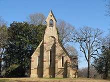 |
June 13, 1972 (#72000698) |
6 miles northwest of the junction of Interstate 55 and Mississippi Highway 463 32°31′18″N 90°11′24″W / 32.521667°N 90.19°W |
Mannsdale | |
| 7 | John Curran House | March 2, 1986 (#86000516) |
Main St. 32°27′45″N 90°06′59″W / 32.4625°N 90.116389°W |
Madison | ||
| 8 | Doak's Stand Treaty Site | January 30, 1978 (#78003196) |
Along Sulphur Springs Rd., northeast of Canton[8] 32°42′45″N 89°48′57″W / 32.7125°N 89.8158°W |
Canton | ||
| 9 | Dorroh Street Historic District | March 2, 1986 (#86000514) |
103, 105, and 115 Dorroh St. 32°27′27″N 90°06′52″W / 32.4574°N 90.114444°W |
Madison | ||
| 10 | East Canton Historic District | April 13, 1998 (#98000274) |
Roughly along E. Academy, E. Center, E. Fulton, Lyons, Madison, E. Peace, and Priestly Sts. 32°36′43″N 90°01′37″W / 32.611944°N 90.026944°W |
Canton | ||
| 11 | Fairview School | February 11, 2009 (#08000199) |
1278 N. Old Canton Rd. 32°30′17″N 90°02′23″W / 32.5047515°N 90.0397357°W |
Canton | ||
| 12 | Farr Mercantile Co.-R.B. Price Mercantile Co. | March 2, 1986 (#86000517) |
Main and Railroad 32°27′43″N 90°06′56″W / 32.461944°N 90.115556°W |
Madison | ||
| 13 | Kirkpatrick Dental Office | July 9, 1991 (#91000878) |
229 E. Center St. 32°36′50″N 90°01′51″W / 32.613889°N 90.030833°W |
Canton | ||
| 14 | Long Moss Plantation House | March 1, 1996 (#96000180) |
305 Quail Rd. 32°39′29″N 89°58′16″W / 32.658056°N 89.971111°W |
Canton | ||
| 15 | Madison County Jail |  |
March 28, 1979 (#79001330) |
234 E. Fulton St. 32°36′37″N 90°01′53″W / 32.610278°N 90.031389°W |
Canton | |
| 16 | Madison-Ridgeland Public School |  |
March 2, 1986 (#86000518) |
Montgomery St. 32°27′37″N 90°06′52″W / 32.460278°N 90.114444°W |
Madison | |
| 17 | Mississippi Institute of Aeronautics Aircraft Hangars |  |
August 24, 2005 (#05000910) |
Bruce Campbell Field, 7496 Old Canton Rd. 32°26′40″N 90°06′19″W / 32.444444°N 90.105278°W |
Madison | |
| 18 | Montgomery House | 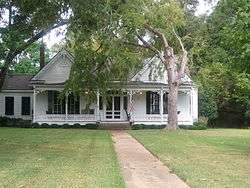 |
September 7, 1984 (#84002260) |
Main St. 32°27′42″N 90°07′06″W / 32.461667°N 90.118333°W |
Madison | |
| 19 | Mt. Zion Baptist Church | April 6, 2000 (#00000333) |
514 W. North St. 32°36′54″N 90°02′29″W / 32.615°N 90.041389°W |
Canton | ||
| 20 | Old Natchez Trace and Choctaw Agency Site | February 2, 1995 (#94001579) |
Between Interstate 55 and Livingston Rd., west of Ridgeland 32°25′36″N 90°10′37″W / 32.426667°N 90.176944°W |
Ridgeland | Includes a 3.3-mile segment of the Natchez Trace (partially in the Natchez Trace Parkway right of way) and an archeological investigation site at the location that from 1811 to 1823 housed a government agency to the Choctaw.[9] | |
| 21 | Old Natchez Trace (170-30) | 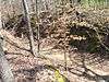 |
November 7, 1976 (#76000160) |
East of Ridgeland at Natchez Trace Parkway milepost 104.6 32°25′27″N 90°05′19″W / 32.424167°N 90.088611°W |
Ridgeland | Two segments of the Natchez Trace located at a Natchez Trace Parkway interpretive stop.[10] |
| 22 | Puckshunubbee-Haley Site | May 9, 1984 (#84002264) |
Address Restricted |
Madison | ||
| 23 | Sedgewood Plantation | 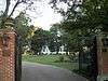 |
November 29, 2000 (#00001400) |
2607 Virlilia Rd. 32°37′05″N 90°16′26″W / 32.618056°N 90.273889°W |
Canton | |
| 24 | Charles F. Smith House |  |
March 7, 1994 (#94000145) |
140 Semmes Ave. 32°36′26″N 90°01′59″W / 32.607222°N 90.033056°W |
Canton | |
| 25 | Strawberry Fields Site (22Md644) | December 22, 1988 (#88002707) |
Address Restricted |
Canton | ||
| 26 | Strawberry Patch-McKay House | 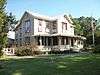 |
March 2, 1986 (#86000515) |
Old Canton Rd. 32°26′53″N 90°06′21″W / 32.448056°N 90.105833°W |
Madison | |
| 27 | Tilda Bogue | December 9, 1983 (#83003965) |
Address Restricted |
Canton | ||
| 28 | Tougaloo College | |
August 31, 1998 (#98001109) |
Tougaloo 32°24′13″N 90°09′27″W / 32.403611°N 90.1575°W |
Tougaloo | |
| 29 | White Perch Paradise Site (22MD641) | February 27, 1987 (#87000226) |
Address Restricted |
Goshen Springs | ||
| 30 | Yazoo & Mississippi Valley Railroad Depot | October 31, 1995 (#95001195) |
Vernon St. between the Illinois Central railroad tracks and Main St. 32°32′36″N 90°18′34″W / 32.543333°N 90.309444°W |
Flora | ||
| 31 | Young House |  |
November 10, 2008 (#08001046) |
3463 N. Liberty St. 32°37′19″N 90°02′03″W / 32.621874°N 90.03411189999997°W |
Canton |
See also
References
- ↑ The latitude and longitude information provided in this table was derived originally from the National Register Information System, which has been found to be fairly accurate for about 99% of listings. For about 1% of NRIS original coordinates, experience has shown that one or both coordinates are typos or otherwise extremely far off; some corrections may have been made. A more subtle problem causes many locations to be off by up to 150 yards, depending on location in the country: most NRIS coordinates were derived from tracing out latitude and longitudes from USGS topographical quadrant maps created under the North American Datum of 1927, which differs from the current, highly accurate WGS84 GPS system used by most on-line maps. Chicago is about right, but NRIS longitudes in Washington are higher by about 4.5 seconds, and are lower by about 2.0 seconds in Maine. Latitudes differ by about 1.0 second in Florida. Some locations in this table may have been corrected to current GPS standards.
- ↑ "National Register of Historic Places: Weekly List Actions". National Park Service, United States Department of the Interior. Retrieved on October 11, 2018.
- ↑ Numbers represent an ordering by significant words. Various colorings, defined here, differentiate National Historic Landmarks and historic districts from other NRHP buildings, structures, sites or objects.
- ↑ National Park Service (2009-03-13). "National Register Information System". National Register of Historic Places. National Park Service.
- ↑ The eight-digit number below each date is the number assigned to each location in the National Register Information System database, which can be viewed by clicking the number.
- ↑ Location derived from this National Park Service webpage
- ↑ "Indian Mounds of Mississippi : Boyd Mounds Site". NPS.GOV.
- ↑ Location derived from its GNIS feature record; the NRIS lists the site as "Address Restricted"
- ↑ Old Natchez Trace and Choctaw Agency site (Other names: Natchez Trace Section 3P; Old Agency Road; and Choctaw Agency Site 22Md645), National Register of Historic Places Registration Form, November 22, 1994
- ↑ Old Natchez Trace (No. 170-30) (Alternate names: Path to Choctaw Nation, Chickasaw Trace, Natchez Trace), National Register of Historic Places Inventory Nomination Form for Federal Properties, prepared September 9, 1974; received March 25, 1976; entered November 7, 1976
| Wikimedia Commons has media related to National Register of Historic Places in Madison County, Mississippi. |
| Topics | |
|---|---|
| Lists by states |
|
| Lists by insular areas | |
| Lists by associated states | |
| Other areas | |
| |
Municipalities and communities of Madison County, Mississippi, United States | ||
|---|---|---|
| Cities | | |
| Towns | ||
| CDP | ||
| Other unincorporated communities | ||
| Ghost town | ||
| Footnotes | ‡This populated place also has portions in an adjacent county or counties | |
This article is issued from
Wikipedia.
The text is licensed under Creative Commons - Attribution - Sharealike.
Additional terms may apply for the media files.