National Register of Historic Places listings in Grenada County, Mississippi
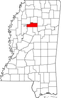
Location of Grenada County in Mississippi
This is a list of the National Register of Historic Places listings in Grenada County, Mississippi.
This is intended to be a complete list of the properties and districts on the National Register of Historic Places in Grenada County, Mississippi, United States. Latitude and longitude coordinates are provided for many National Register properties and districts; these locations may be seen together in a map.[1]
There are 16 properties and districts listed on the National Register in the county.
- This National Park Service list is complete through NPS recent listings posted October 11, 2018.[2]
Current listings
| [3] | Name on the Register[4] | Image | Date listed[5] | Location | City or town | Description |
|---|---|---|---|---|---|---|
| 1 | Confederate Earthworks | July 2, 1973 (#73001008) |
West of Grenada off Mississippi Highway 8 33°47′46″N 89°46′23″W / 33.796111°N 89.773056°W |
Grenada | ||
| 2 | Confederate Redoubt | May 29, 2015 (#15000296) |
Springhill Rd. 33°46′36″N 89°49′11″W / 33.776635°N 89.819641°W |
Grenada | ||
| 3 | Evergreen Plantation | October 18, 1977 (#77000786) |
4 miles north of Grenada on Hardy Rd. 33°50′10″N 89°50′38″W / 33.836111°N 89.843889°W |
Grenada | ||
| 4 | Glenwild Plantation Manager's House | 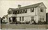 |
May 12, 1999 (#99000499) |
3557 U.S. Highway 51, S. 33°43′11″N 89°46′49″W / 33.719722°N 89.780278°W |
Grenada | |
| 5 | Grenada Bank | 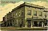 |
November 28, 1978 (#78001598) |
223 1st St. 33°47′02″N 89°48′07″W / 33.783889°N 89.801944°W |
Grenada | |
| 6 | Grenada Downtown Historic District | September 10, 2014 (#14000563) |
Bounded by Pearl, Mound, 2nd, South, Lynch & Doak Sts. 33°47′04″N 89°48′09″W / 33.7845°N 89.8025°W |
Grenada | ||
| 7 | Grenada Masonic Temple | January 20, 1988 (#87002307) |
210 S. Main St. 33°46′58″N 89°48′09″W / 33.782778°N 89.8025°W |
Grenada | ||
| 8 | Illinois Central Depot | 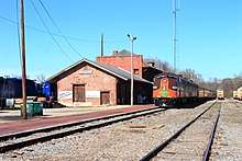 |
April 7, 1988 (#87002308) |
643 1st St. 33°46′57″N 89°47′51″W / 33.7825°N 89.7975°W |
Grenada | Now used by the Grenada Railway. |
| 9 | Lee-Dubard House | January 20, 1988 (#87002312) |
317 3rd St. 33°46′52″N 89°48′07″W / 33.781111°N 89.801944°W |
Grenada | ||
| 10 | Margin St. Historic District |  |
April 7, 1988 (#87002338) |
Margin St. and part of Line St. between Commerce and Green Sts. 33°46′57″N 89°48′25″W / 33.7825°N 89.806944°W |
Grenada | |
| 11 | Odd Fellows and Confederate Cemetery | January 20, 1988 (#87002341) |
Corner of Cemetery and Commerce Sts. 33°46′28″N 89°48′39″W / 33.774444°N 89.810833°W |
Grenada | ||
| 12 | Providence Cemetery | October 2, 1991 (#91001423) |
Providence Rd. east of Grenada 33°42′53″N 89°37′04″W / 33.714722°N 89.617778°W |
Grenada | ||
| 13 | South Main Historic District |  |
January 20, 1988 (#87002345) |
S. Main St. 33°46′51″N 89°48′13″W / 33.780833°N 89.803611°W |
Grenada | |
| 14 | US Post Office-Grenada | January 9, 1985 (#85000117) |
178 S. Main St. 33°46′46″N 89°48′25″W / 33.779444°N 89.806944°W |
Grenada | ||
| 15 | Sen. Edward C. Walthall House | January 20, 1988 (#87002349) |
73 College Boulevard 33°46′40″N 89°48′14″W / 33.777778°N 89.803889°W |
Grenada | ||
| 16 | Wild Wings Mounds (22Gr713) | December 14, 1988 (#88002704) |
Address Restricted |
Holcomb |
See also
| Wikimedia Commons has media related to National Register of Historic Places in Grenada County, Mississippi. |
References
- ↑ The latitude and longitude information provided in this table was derived originally from the National Register Information System, which has been found to be fairly accurate for about 99% of listings. For about 1% of NRIS original coordinates, experience has shown that one or both coordinates are typos or otherwise extremely far off; some corrections may have been made. A more subtle problem causes many locations to be off by up to 150 yards, depending on location in the country: most NRIS coordinates were derived from tracing out latitude and longitudes from USGS topographical quadrant maps created under the North American Datum of 1927, which differs from the current, highly accurate WGS84 GPS system used by most on-line maps. Chicago is about right, but NRIS longitudes in Washington are higher by about 4.5 seconds, and are lower by about 2.0 seconds in Maine. Latitudes differ by about 1.0 second in Florida. Some locations in this table may have been corrected to current GPS standards.
- ↑ "National Register of Historic Places: Weekly List Actions". National Park Service, United States Department of the Interior. Retrieved on October 11, 2018.
- ↑ Numbers represent an ordering by significant words. Various colorings, defined here, differentiate National Historic Landmarks and historic districts from other NRHP buildings, structures, sites or objects.
- ↑ National Park Service (2009-03-13). "National Register Information System". National Register of Historic Places. National Park Service.
- ↑ The eight-digit number below each date is the number assigned to each location in the National Register Information System database, which can be viewed by clicking the number.
| Topics | |
|---|---|
| Lists by states |
|
| Lists by insular areas | |
| Lists by associated states | |
| Other areas | |
| |
Municipalities and communities of Grenada County, Mississippi, United States | ||
|---|---|---|
| Cities | | |
| CDPs | ||
| Other unincorporated communities | ||
This article is issued from
Wikipedia.
The text is licensed under Creative Commons - Attribution - Sharealike.
Additional terms may apply for the media files.