| [2] |
Name on the Register |
Image |
Date listed[3] |
Location |
City or town |
Description |
|---|
| 1 |
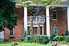
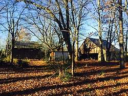
Adams House |
|
September 1, 1983
(#83000199) |
Hartwell Rd.
34°25′52″N 83°05′37″W / 34.431111°N 83.093611°W / 34.431111; -83.093611 (Adams House) |
Lavonia |
|
| 2 |
William Ariail House |
|
November 7, 1996
(#96001297) |
GA 51, approximately .25 mi. SE of the Banks-Franklin County line
34°21′54″N 83°23′05″W / 34.365°N 83.384722°W / 34.365; -83.384722 (William Ariail House) |
Carnesville |
|
| 3 |
Ayers-Little Boarding House |
|
April 16, 2008
(#08000292) |
121 Athens St.
34°22′12″N 83°14′05″W / 34.369998°N 83.234710°W / 34.369998; -83.234710 (Ayers-Little Boarding House) |
Carnesville |
Frame one- and one-half-story house located at the southeast corner of the courthouse square in Carnesville, GA. |
| 4 |
Baty School |
|
November 7, 1996
(#96001302) |
GA 198, approximately .25 mi. N of jct. with GA 59
34°21′40″N 83°16′53″W / 34.361111°N 83.281389°W / 34.361111; -83.281389 (Baty School) |
Carnesville |
|
| 5 |
Beasley House |
|
September 1, 1983
(#83000200) |
75 Grogan St.
34°26′11″N 83°06′08″W / 34.436389°N 83.102222°W / 34.436389; -83.102222 (Beasley House) |
Lavonia |
|
| 6 |
Bellamy Historic District |
|
November 7, 1996
(#96001304) |
GA 51, approximately 2.75 mi. NW of jct. with I-85
34°22′17″N 83°21′55″W / 34.371389°N 83.365278°W / 34.371389; -83.365278 (Bellamy Historic District) |
Carnesville |
|
| 7 |
John R. and Mary Bond Bond House |
|
November 7, 1996
(#96001301) |
GA 59, approximately .5 mi. NE of jct. with GA 51
34°20′50″N 83°18′29″W / 34.347222°N 83.308056°W / 34.347222; -83.308056 (John R. and Mary Bond Bond House) |
Carnesville |
|
| 8 |
Bond-Baker-Carter House |
|
September 11, 1986
(#86002403) |
Address Restricted
|
Royston |
|
| 9 |
Brown-Kennedy House |
|
November 7, 1996
(#96001303) |
GA 59, approximately 1 mi. NE of jct. with GA 51
34°21′03″N 83°18′02″W / 34.350833°N 83.300556°W / 34.350833; -83.300556 (Brown-Kennedy House) |
Carnesville |
|
| 10 |
Burton House |
|
September 1, 1983
(#83000201) |
Augusta Rd.
34°25′57″N 83°06′27″W / 34.4325°N 83.1075°W / 34.4325; -83.1075 (Burton House) |
Lavonia |
|
| 11 |
Cannon-McDaniel House |
|
September 1, 1983
(#83000202) |
126 West Ave.
34°26′01″N 83°07′00″W / 34.433611°N 83.116667°W / 34.433611; -83.116667 (Cannon-McDaniel House) |
Lavonia |
|
| 12 |
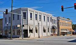
Canon Commercial Historic District |
|
August 1, 1985
(#85001681) |
Depot St. between Bond Ave. & Broad St.
34°20′46″N 83°06′36″W / 34.346111°N 83.11°W / 34.346111; -83.11 (Canon Commercial Historic District) |
Canon |
|
| 13 |
Cason House |
|
September 1, 1983
(#83000203) |
60 Grogan St.
34°26′11″N 83°06′13″W / 34.436389°N 83.103611°W / 34.436389; -83.103611 (Cason House) |
Lavonia |
|
| 14 |
Cheek House |
|
September 1, 1983
(#83000204) |
38 Hartwell Rd.
34°26′02″N 83°06′05″W / 34.433889°N 83.101389°W / 34.433889; -83.101389 (Cheek House) |
Lavonia |
|
| 15 |
Crawford-Shirley House |
|
September 1, 1983
(#83000205) |
100 Augusta Rd.
34°25′41″N 83°06′22″W / 34.428056°N 83.106111°W / 34.428056; -83.106111 (Crawford-Shirley House) |
Lavonia |
|
| 16 |
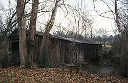
Cromer's Mill Covered Bridge |
|
August 17, 1976
(#76000619) |
8 mi. S of Carnesville at Nails Creek
34°16′29″N 83°15′57″W / 34.274722°N 83.265833°W / 34.274722; -83.265833 (Cromer's Mill Covered Bridge) |
Carnesville |
|
| 17 |
Fisher House |
|
September 1, 1983
(#83000206) |
221 Hartwell Rd.
34°25′59″N 83°05′57″W / 34.433056°N 83.099167°W / 34.433056; -83.099167 (Fisher House) |
Lavonia |
|
| 18 |
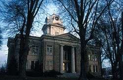
Franklin County Courthouse |
|
September 18, 1980
(#80001069) |
Courthouse Sq.
34°22′12″N 83°14′05″W / 34.369998°N 83.234710°W / 34.369998; -83.234710 (Franklin County Courthouse) |
Carnesville |
|
| 19 |
Hamilton Historic District |
|
November 7, 1996
(#96001300) |
GA 51, approximately .5 mi. NW of jct. with I-85
34°20′54″N 83°19′49″W / 34.348333°N 83.330278°W / 34.348333; -83.330278 (Hamilton Historic District) |
Carnesville |
|
| 20 |
Historic Churches of Canon Historic District |
|
August 1, 1985
(#85001680) |
Broad St. at Canon Ave.
34°20′41″N 83°06′35″W / 34.344722°N 83.109722°W / 34.344722; -83.109722 (Historic Churches of Canon Historic District) |
Canon |
|
| 21 |
Jones Street Residential Historic District |
|
September 1, 1983
(#83000207) |
Jones, Baker, and Old Carnesville Rd.
34°26′16″N 83°06′32″W / 34.437778°N 83.108889°W / 34.437778; -83.108889 (Jones Street Residential Historic District) |
Lavonia |
|
| 22 |
Keese House |
|
September 1, 1983
(#83000208) |
4 Burgess St.
34°25′57″N 83°06′34″W / 34.4325°N 83.109444°W / 34.4325; -83.109444 (Keese House) |
Lavonia |
|
| 23 |
Kidd House |
|
September 1, 1983
(#83000209) |
222 Hartwell Rd.
34°25′56″N 83°06′00″W / 34.432222°N 83.1°W / 34.432222; -83.1 (Kidd House) |
Lavonia |
|
| 24 |
Killingsworth Farm |
|
September 1, 1983
(#83000210) |
Hartwell Rd.
34°25′54″N 83°05′27″W / 34.431667°N 83.090833°W / 34.431667; -83.090833 (Killingsworth Farm) |
Lavonia |
|
| 25 |
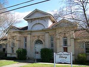
Lavonia-Carnegie Library |
|
September 1, 1983
(#83000211) |
Hartwell Rd.
34°26′05″N 83°06′14″W / 34.434722°N 83.103889°W / 34.434722; -83.103889 (Lavonia-Carnegie Library) |
Lavonia |
|
| 26 |
Lavonia Commercial Historic District |
|
September 1, 1983
(#83000212) |
Jones, Augusta, Vickery, Grogan, Bowman Sts.
34°26′10″N 83°06′24″W / 34.436111°N 83.106667°W / 34.436111; -83.106667 (Lavonia Commercial Historic District) |
Lavonia |
|
| 27 |
Lavonia Cotton Mill |
|
September 1, 1983
(#83000213) |
Main St.
34°25′45″N 83°06′08″W / 34.429167°N 83.102222°W / 34.429167; -83.102222 (Lavonia Cotton Mill) |
Lavonia |
|
| 28 |
Lavonia Roller Mill |
|
September 1, 1983
(#83000214) |
E. Main St.
34°26′01″N 83°06′17″W / 34.433611°N 83.104722°W / 34.433611; -83.104722 (Lavonia Roller Mill) |
Lavonia |
|
| 29 |
McConnell Historic District |
|
November 7, 1996
(#96001299) |
GA 51, approximately 2.5 mi. NW of jct. with I-85
34°22′00″N 83°21′13″W / 34.366667°N 83.353611°W / 34.366667; -83.353611 (McConnell Historic District) |
Carnesville |
|
| 30 |
McMurray House |
|
September 1, 1983
(#83000215) |
Hartwell Rd.
34°25′59″N 83°06′03″W / 34.433056°N 83.100833°W / 34.433056; -83.100833 (McMurray House) |
Lavonia |
|
| 31 |
Pure Oil Service Station |
|
September 1, 1983
(#83000216) |
56 West Ave.
34°26′07″N 83°06′28″W / 34.435278°N 83.107778°W / 34.435278; -83.107778 (Pure Oil Service Station) |
Lavonia |
|
| 32 |
Queen House |
|
September 1, 1983
(#83000217) |
Hartwell Rd.
34°25′54″N 83°05′25″W / 34.431667°N 83.090278°W / 34.431667; -83.090278 (Queen House) |
Lavonia |
|
| 33 |
Royston Commercial Historic District |
|
September 5, 1985
(#85001969) |
Along Church and Railroad Sts.
34°17′12″N 83°06′37″W / 34.286667°N 83.110278°W / 34.286667; -83.110278 (Royston Commercial Historic District) |
Royston |
|
| 34 |
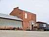
Southern Cotton Oil Co. |
|
September 1, 1983
(#83000218) |
W. Main St.
34°26′00″N 83°06′20″W / 34.433333°N 83.105556°W / 34.433333; -83.105556 (Southern Cotton Oil Co.) |
Lavonia |
|
| 35 |
Stevenson House and Brickyard |
|
September 1, 1983
(#83000219) |
Hartwell Rd.
34°26′02″N 83°06′08″W / 34.433889°N 83.102222°W / 34.433889; -83.102222 (Stevenson House and Brickyard) |
Lavonia |
|
| 36 |
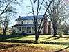
Stovall Homeplace |
|
September 1, 1983
(#83000220) |
114 West Ave.
34°25′48″N 83°07′02″W / 34.43°N 83.117222°W / 34.43; -83.117222 (Stovall Homeplace) |
Lavonia |
|
| 37 |
Stovall-Purcell House |
|
September 1, 1983
(#83000221) |
110 West Ave.
34°26′00″N 83°06′54″W / 34.433333°N 83.115°W / 34.433333; -83.115 (Stovall-Purcell House) |
Lavonia |
|
| 38 |
Strange-Duncan House |
|
November 7, 1996
(#96001298) |
GA 51, approximately .75 mi. E of the Franklin-Banks County line
34°22′16″N 83°22′48″W / 34.371111°N 83.38°W / 34.371111; -83.38 (Strange-Duncan House) |
Carnesville |
|
| 39 |
Vandiver House |
|
September 1, 1983
(#83000222) |
Main St.
34°26′28″N 83°06′36″W / 34.441111°N 83.11°W / 34.441111; -83.11 (Vandiver House) |
Lavonia |
|
| 40 |
Vickery House |
|
September 1, 1983
(#83000223) |
Grogan St.
34°26′10″N 83°06′15″W / 34.436111°N 83.104167°W / 34.436111; -83.104167 (Vickery House) |
Lavonia |
|
| 41 |
Vickery Street Historic District |
|
September 1, 1983
(#83000224) |
Vickery St.
34°26′28″N 83°06′23″W / 34.441111°N 83.106389°W / 34.441111; -83.106389 (Vickery Street Historic District) |
Lavonia |
|
| 42 |
Walnut Hill Historic District |
|
November 7, 1996
(#96001296) |
GA 51, approximately 1 mi. NW of jct. with I-85
34°21′23″N 83°20′34″W / 34.356389°N 83.342778°W / 34.356389; -83.342778 (Walnut Hill Historic District) |
Carnesville |
|
| 43 |
West Avenue-Roberts Street Residential Historic District |
|
September 1, 1983
(#83000225) |
Between Mason and Jones Sts.
34°26′05″N 83°06′36″W / 34.434722°N 83.11°W / 34.434722; -83.11 (West Avenue-Roberts Street Residential Historic District) |
Lavonia |
|
| 44 |
Yow House |
|
September 1, 1983
(#83000226) |
109 Hartwell Rd.
34°26′01″N 83°06′02″W / 34.433611°N 83.100556°W / 34.433611; -83.100556 (Yow House) |
Lavonia |
|