| [3] |
Name on the Register[4] |
Image |
Date listed[5] |
Location |
City or town |
Description |
|---|
| 1 |
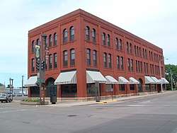
Aberdeen Commercial Historic District |
|
May 23, 1988
(#88000586) |
1-523 South Main Street
45°27′44″N 98°29′16″W / 45.462222°N 98.487778°W / 45.462222; -98.487778 (Aberdeen Commercial Historic District) |
Aberdeen |
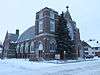
|
| 2 |
Aberdeen Highlands Historic District |
|
June 5, 1975
(#75001710) |
Both sides of North Main from 12th to 15th Avenue, N.E.
45°28′46″N 98°29′15″W / 45.479444°N 98.4875°W / 45.479444; -98.4875 (Aberdeen Highlands Historic District) |
Aberdeen |
|
| 3 |
Aberdeen Historic District |
|
June 5, 1975
(#75001711) |
Both sides of 3rd-6th Avenues and Jay, Kline, and Arch Streets
45°27′38″N 98°28′55″W / 45.460556°N 98.481944°W / 45.460556; -98.481944 (Aberdeen Historic District) |
Aberdeen |
|
| 4 |
Augustana Swedish Lutheran Church |
|
December 20, 1988
(#88002842) |
4.5 miles south of Claremont
45°36′04″N 98°00′02″W / 45.601111°N 98.000556°W / 45.601111; -98.000556 (Augustana Swedish Lutheran Church) |
Claremont |
|
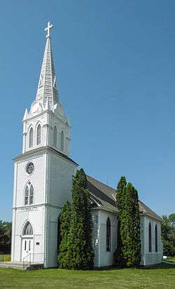
| 5 |
Aurland United Norwegian Lutheran Church |
|
April 16, 1982
(#82003916) |
Southeast of Frederick
45°46′14″N 98°24′55″W / 45.770448°N 98.415208°W / 45.770448; -98.415208 (Aurland United Norwegian Lutheran Church) |
Frederick |
|
| 6 |
William G. Bickelhaupt House |
|
October 19, 1989
(#89001727) |
1003 South Jay
45°27′16″N 98°29′00″W / 45.454523°N 98.483262°W / 45.454523; -98.483262 (William G. Bickelhaupt House) |
Aberdeen |
|
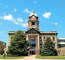
| 7 |
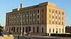
Brown County Courthouse |
|
June 3, 1976
(#76001718) |
First Avenue
45°27′52″N 98°29′10″W / 45.464444°N 98.486111°W / 45.464444; -98.486111 (Brown County Courthouse) |
Aberdeen |
|
| 8 |
Brown Hall |
|
February 7, 1990
(#89002336) |
Main Street
45°43′55″N 98°29′50″W / 45.7319°N 98.4971°W / 45.7319; -98.4971 (Brown Hall) |
Barnard |
|
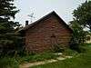
| 9 |
Brown's Post |
|
May 27, 1988
(#88000583) |
Address Restricted
|
Sisseton |
|
| 10 |
Colin Campbell Post |
|
May 27, 1988
(#88000584) |
Address Restricted
|
Frederick |
|
| 11 |
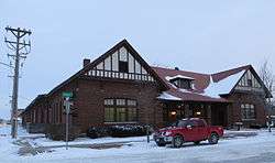
Chicago, Milwaukee, St. Paul and Pacific Railroad Depot |
|
September 20, 1977
(#77001238) |
Main Street and Railroad Avenue
45°27′56″N 98°29′20″W / 45.465556°N 98.488889°W / 45.465556; -98.488889 (Chicago, Milwaukee, St. Paul and Pacific Railroad Depot) |
Aberdeen |
|
| 12 |
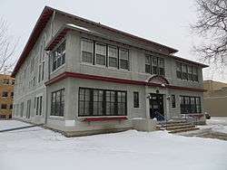
Dakota Farmer Building |
|
August 1, 1984
(#84003221) |
1216 South Main Street
45°27′07″N 98°29′19″W / 45.451999°N 98.488590°W / 45.451999; -98.488590 (Dakota Farmer Building) |
Aberdeen |
|
| 13 |
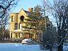
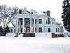
Easton's Castle |
|
March 1, 1973
(#73001736) |
1210 Second Avenue, N.W.
45°28′07″N 98°30′15″W / 45.468611°N 98.504167°W / 45.468611; -98.504167 (Easton's Castle) |
Aberdeen |
|
| 14 |
Finnish Apostolic Lutheran Church |
|
May 31, 1984
(#84003223) |
101 Street and 392 Avenue[6]
45°55′24″N 98°23′38″W / 45.923291°N 98.393968°W / 45.923291; -98.393968 (Finnish Apostolic Lutheran Church) |
Frederick |
|
| 15 |
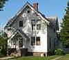
John H. Firey House |
|
March 23, 1995
(#95000277) |
418 South Arch Street
45°27′38″N 98°28′52″W / 45.460458°N 98.481047°W / 45.460458; -98.481047 (John H. Firey House) |
Aberdeen |
|
| 16 |
First United Methodist Church |
|
May 28, 1976
(#76001719) |
S. Lincoln St. and SE. 5th Ave.
45°27′36″N 98°29′12″W / 45.46°N 98.486667°W / 45.46; -98.486667 (First United Methodist Church) |
Aberdeen |
|
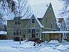
| 17 |
Foght-Murdy House |
|
March 23, 1995
(#95000276) |
1403 S. Main St.
45°27′18″N 98°29′17″W / 45.455°N 98.488056°W / 45.455; -98.488056 (Foght-Murdy House) |
Aberdeen |
|
| 18 |
Paul and Fredriika Geranen Farm |
|
November 13, 1985
(#85003498) |
East of Frederick
45°51′00″N 98°24′48″W / 45.85°N 98.413333°W / 45.85; -98.413333 (Paul and Fredriika Geranen Farm) |
Frederick |
|
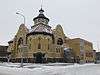
| 19 |
Great Northern Railway Passenger and Freight Depot |
|
January 27, 1983
(#83003002) |
1 Court St.
45°27′54″N 98°29′07″W / 45.465°N 98.485278°W / 45.465; -98.485278 (Great Northern Railway Passenger and Freight Depot) |
Aberdeen |
|
| 20 |
Anna Herron Farm |
|
June 30, 1995
(#95000778) |
1.5 miles east of Highway 18 on County Highway 21 near Groton
45°23′11″N 98°11′47″W / 45.386389°N 98.196389°W / 45.386389; -98.196389 (Anna Herron Farm) |
West Hanson Township |
|
| 21 |
Art Karl Farm |
|
July 7, 1995
(#95000777) |
Southeastern corner of the junction of Highways 14 and 21 near Aberdeen
45°23′10″N 98°24′41″W / 45.386111°N 98.411389°W / 45.386111; -98.411389 (Art Karl Farm) |
West Gem Township |
|
| 22 |
Margaret and Maurice Lamont House |
|
March 23, 1995
(#95000281) |
515 S. Arch St.
45°27′34″N 98°28′50″W / 45.459528°N 98.480443°W / 45.459528; -98.480443 (Margaret and Maurice Lamont House) |
Aberdeen |
|
| 23 |
Martilla-Pettingel and Gorder General Merchandise Store |
|
November 13, 1985
(#85003490) |
312 Main St.[7]
45°49′57″N 98°30′21″W / 45.832519°N 98.505892°W / 45.832519; -98.505892 (Martilla-Pettingel and Gorder General Merchandise Store) |
Frederick |
|
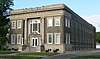
| 24 |
Masonic Temple |
|
May 29, 1980
(#80003719) |
503 S. Main St.
45°27′35″N 98°29′15″W / 45.459722°N 98.4875°W / 45.459722; -98.4875 (Masonic Temple) |
Aberdeen |
|
| 25 |
McGregor House |
|
June 8, 2005
(#05000591) |
621 S. Kline St.
45°27′30″N 98°28′55″W / 45.458217°N 98.481915°W / 45.458217; -98.481915 (McGregor House) |
Aberdeen |
|
| 26 |
McKenzie-Cassels House |
|
February 13, 1986
(#86000242) |
508 N. 3rd St.
45°27′04″N 98°05′49″W / 45.451111°N 98.096944°W / 45.451111; -98.096944 (McKenzie-Cassels House) |
Groton |
|
| 27 |
Minneapolis and St. Louis Railroad Depot |
|
September 28, 1976
(#76001720) |
1100 S. Main St.
45°27′14″N 98°29′17″W / 45.453889°N 98.488056°W / 45.453889; -98.488056 (Minneapolis and St. Louis Railroad Depot) |
Aberdeen |
|
| 28 |
Modern Woodmen of America Hall |
|
July 7, 1995
(#95000775) |
Northwestern corner of the junction of Main and 2nd Sts.
45°14′35″N 98°33′46″W / 45.243056°N 98.562778°W / 45.243056; -98.562778 (Modern Woodmen of America Hall) |
Mansfield |
|
| 29 |
George Pfutzenreuter House |
|
June 21, 1990
(#90000955) |
411 3rd St.
45°52′54″N 98°09′09″W / 45.881667°N 98.1525°W / 45.881667; -98.1525 (George Pfutzenreuter House) |
Hecla |
|
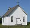
| 30 |
Plana School |
|
July 7, 1995
(#95000773) |
7 miles north of Highway 12 and 1 mile east of County Highway 16
45°31′04″N 98°18′34″W / 45.5178°N 98.3094°W / 45.5178; -98.3094 (Plana School) |
Plana |
|
| 31 |
Melchior Ryman Farm |
|
June 30, 1995
(#95000771) |
2 miles west of Highway 281, 3 miles north of Mansfield
45°17′13″N 98°33′30″W / 45.286944°N 98.558333°W / 45.286944; -98.558333 (Melchior Ryman Farm) |
Mansfield |
|
| 32 |
Savo Hall-Finnish National Society Hall |
|
November 13, 1985
(#85003494) |
104 St and 391 Ave[8]
45°52′47″N 98°24′51″W / 45.879698°N 98.414216°W / 45.879698; -98.414216 (Savo Hall-Finnish National Society Hall) |
Savo Township |
|
| 33 |
Simmons House |
|
August 1, 1984
(#84003224) |
1408 S. Main St.
45°27′01″N 98°29′19″W / 45.450278°N 98.488611°W / 45.450278; -98.488611 (Simmons House) |
Aberdeen |
|
| 34 |
South Dakota Dept. of Transportation Bridge No. 07-009-060 |
|
March 9, 2000
(#00000185) |
Local road over Elm Dam Spillway
45°51′07″N 98°42′22″W / 45.851944°N 98.706111°W / 45.851944; -98.706111 (South Dakota Dept. of Transportation Bridge No. 07-009-060) |
Frederick |
|
| 35 |
South Dakota Dept. of Transportation Bridge No. 07-220-454 |
|
March 9, 2000
(#00000184) |
Local road over Mud Creek
45°16′13″N 98°17′16″W / 45.270278°N 98.287778°W / 45.270278; -98.287778 (South Dakota Dept. of Transportation Bridge No. 07-220-454) |
Stratford |
|
| 36 |
South Dakota Dept. of Transportation Bridge No. 07-268-030 |
|
March 9, 2000
(#00000186) |
Local road over the James River
45°53′35″N 98°10′33″W / 45.893056°N 98.175833°W / 45.893056; -98.175833 (South Dakota Dept. of Transportation Bridge No. 07-268-030) |
Hecla |
|
| 37 |
South Dakota Dept. of Transportation Bridge No. 07-304-414 |
|
March 9, 2000
(#00000187) |
Local road over Ferney Ravine
45°20′19″N 98°05′43″W / 45.338611°N 98.095278°W / 45.338611; -98.095278 (South Dakota Dept. of Transportation Bridge No. 07-304-414) |
Ferney |
|
| 38 |
Trinity Episcopal Church |
|
January 27, 1983
(#83003003) |
Third Avenue East and Third Street North
45°26′55″N 98°05′54″W / 45.448611°N 98.098333°W / 45.448611; -98.098333 (Trinity Episcopal Church) |
Groton |
|
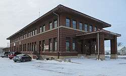
| 39 |
US Post Office and Courthouse-Aberdeen |
|
October 4, 2006
(#06000931) |
102 Forth Avenue, S.E.
45°27′39″N 98°29′09″W / 45.460880°N 98.485791°W / 45.460880; -98.485791 (US Post Office and Courthouse-Aberdeen) |
Aberdeen |
|
| 40 |
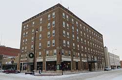
Alonzo Ward Hotel |
|
June 17, 1982
(#82003915) |
104 South Main Street
45°27′50″N 98°29′17″W / 45.463889°N 98.488056°W / 45.463889; -98.488056 (Alonzo Ward Hotel) |
Aberdeen |
|
| 41 |
Welsh Presbyterian Church |
|
July 6, 1995
(#95000776) |
7 miles north of Highway 12 and 1 mile east of Highway 16
45°31′08″N 98°18′39″W / 45.518889°N 98.310833°W / 45.518889; -98.310833 (Welsh Presbyterian Church) |
Plana |
|
| 42 |
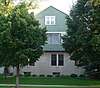
Gustav and Mary Werth House |
|
June 28, 1991
(#91000846) |
1502 North Dakota Street
45°28′52″N 98°28′27″W / 45.481239°N 98.474171°W / 45.481239; -98.474171 (Gustav and Mary Werth House) |
Aberdeen |
|
| 43 |
Western Union Building |
|
December 12, 1976
(#76001721) |
21-23 South Main Street
45°27′52″N 98°29′15″W / 45.464444°N 98.4875°W / 45.464444; -98.4875 (Western Union Building) |
Aberdeen |
|
| 44 |
Wylie Park Pavilion |
|
January 26, 1978
(#78002540) |
North of Aberdeen off U.S. Route 281
45°29′22″N 98°31′00″W / 45.48941°N 98.516584°W / 45.48941; -98.516584 (Wylie Park Pavilion) |
Aberdeen |
|


_from_WNW_1.jpg)
_from_SW_1.jpg)