| [2] |
Name on the Register |
Image |
Date listed[3] |
Location |
City or town |
Description |
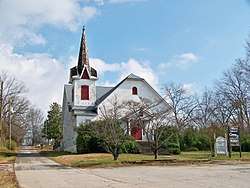
|---|
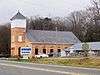
| 1 |
Banks County Courthouse |
|
September 18, 1980
(#80000969) |
Off U.S. 441
34°20′05″N 83°29′56″W / 34.334722°N 83.498889°W / 34.334722; -83.498889 (Banks County Courthouse) |
Homer |
|
| 2 |
Banks County Jail |
|
July 26, 1982
(#82002382) |
Silver Shoals Rd.
34°20′06″N 83°29′20″W / 34.335°N 83.488889°W / 34.335; -83.488889 (Banks County Jail) |
Homer |
|
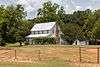
| 3 |
Brooks Family Farm |
|
July 23, 2013
(#13000529) |
584 Silver Shoals Rd.
34°22′14″N 83°33′14″W / 34.3706558°N 83.5538831°W / 34.3706558; -83.5538831 (Brooks Family Farm) |
Lula |
|
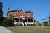
| 4 |
William Chambers House |
|
November 7, 1996
(#96001305) |
GA 51, approximately 1 mi. W of jct. with GA 63
34°22′15″N 83°25′13″W / 34.370833°N 83.420278°W / 34.370833; -83.420278 (William Chambers House) |
Homer |
|
| 5 |
Fort Hollingsworth-White House |
|
August 6, 1998
(#19980806) |
Wynn Lake Rd., 2 mi. SE of Hollingsworth
34°25′35″N 83°32′02″W / 34.426389°N 83.533889°W / 34.426389; -83.533889 (Fort Hollingsworth-White House) |
Hollingsworth |
|
| 6 |
Gillsville Historic District |
|
August 30, 1985
(#85001933) |
GA 52
34°18′38″N 83°38′20″W / 34.310556°N 83.638889°W / 34.310556; -83.638889 (Gillsville Historic District) |
Gillsville |
|
| 7 |
Hebron Church, Cemetery, and Academy |
|
September 12, 1985
(#85002176) |
Hebron Circle
34°17′12″N 83°21′53″W / 34.286667°N 83.364722°W / 34.286667; -83.364722 (Hebron Church, Cemetery, and Academy) |
Commerce |
|
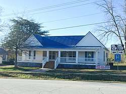
| 8 |
Homer Historic District |
|
December 3, 1985
(#85003110) |
Along Main St. and Silver Shoals Rd.
34°19′59″N 83°29′52″W / 34.333056°N 83.497778°W / 34.333056; -83.497778 (Homer Historic District) |
Homer |
|
| 9 |
Kesler Covered Bridge |
|
June 18, 1975
(#75000571) |
10 mi. N of Homer on County Line Rd. over Middle Fork Broad River
34°25′27″N 83°23′16″W / 34.424167°N 83.387778°W / 34.424167; -83.387778 (Kesler Covered Bridge) |
Homer |
|
| 10 |
Maysville Historic District |
|
September 12, 1985
(#85002203) |
Along E. Main, W. Main and Homer Sts.
34°15′17″N 83°33′48″W / 34.254722°N 83.563333°W / 34.254722; -83.563333 (Maysville Historic District) |
Maysville |
|
| 11 |
Mount Pleasant Historic District |
|
November 7, 1996
(#96001306) |
Jct. of GA 51 and Damascus Road
34°21′53″N 83°26′33″W / 34.3646°N 83.4426°W / 34.3646; -83.4426 (Mount Pleasant Historic District) |
Homer |
|
| 12 |
Nails Creek Historic District |
|
November 7, 1996
(#96001307) |
Jct. of GA 51 and GA 63
34°22′00″N 83°24′02″W / 34.366667°N 83.400556°W / 34.366667; -83.400556 (Nails Creek Historic District) |
Homer |
|
| 13 |
New Salem Covered Bridge |
|
June 10, 1975
(#75000570) |
6 mi. N of Commerce on SR S992 over Grove Creek
34°15′30″N 83°25′20″W / 34.258333°N 83.422222°W / 34.258333; -83.422222 (New Salem Covered Bridge) |
Commerce |
|
| 14 |
Turk Family Farm |
|
January 8, 2003
(#03001365) |
534 Carson Segars Rd.
34°17′37″N 83°32′43″W / 34.293611°N 83.545278°W / 34.293611; -83.545278 (Turk Family Farm) |
Maysville |
|
.jpg)
.JPG)
.JPG)
.JPG)
.JPG)
.JPG)