Amarkantak
| Amarkantaka AmraKutt | |
|---|---|
| Hill station | |
 | |
| Nickname(s): Maikal | |
 Amarkantaka Location in Madhya Pradesh, India  Amarkantaka Amarkantaka (India) | |
| Coordinates: 22°40′N 81°45′E / 22.67°N 81.75°ECoordinates: 22°40′N 81°45′E / 22.67°N 81.75°E | |
| Country |
|
| State | Madhya Pradesh |
| District | Anuppur |
| Government | |
| • Type | Local Government |
| • Body | Nagar Panchayat |
| Area | |
| • Total | 47 km2 (18 sq mi) |
| Elevation | 1,048 m (3,438 ft) |
| Population (2011) | |
| • Total | 8,416 |
| • Density | 181/km2 (470/sq mi) |
| Languages | |
| • Official | Hindi |
| Time zone | UTC+5:30 (IST) |
| PIN | 484886 |
| ISO 3166 code | IN-MP |
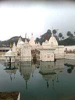
Amarkantak (NLK Amarakaṇṭaka) is a pilgrim town and a Nagar Panchayat in Anuppur, Madhya Pradesh, India. The Amarkantak region is a unique natural heritage area and is the meeting point of the Vindhya and the Satpura Ranges, with the Maikal Hills being the fulcrum. This is where the Narmada River, the Son River and Johila River emerge.
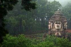
Popular 15th-century Indian mystic and poet Kabir is said to have meditated on Kabir Chabutra, also called the platform of Kabir situated in the town of Amarkantak.[1]
Etymology
Amarkantak is a combination of two Sanskrit words, amara (immortal) and kantaka (obstruction). The poet Kalidas has mentioned it as Amrakuta, which later became Amarkantak.[2]
Location
Amarkantak is located in the state of Madhya Pradesh in India at 22°40′N 81°45′E / 22.67°N 81.75°E. It has an average elevation of 1,048 metres (3,438 ft). Roads running through Rewa, Shahdol, Anuppur, Jabalpur, Katni and Pendra connect it. The nearest railway stations are Anuppur and Pendra Road 43 km via Keonchi and only 28 km via Jwaleshwar. The nearest airport is Dumna Jabalpur (Jabalpur Airport) in the city of Jabalpur, Madhya Pradesh (240 km) which has daily flight service to Delhi and Mumbai.[3] [4]
Demographics
The Amarkantak Nagar Panchayat has population of 8,416 of which 4,514 are males while 3,902 are females as per report released by Census India 2011.
Population of children with age of 0-6 is 921 which is 10.94 % of total population of Amarkantak (NP). In Amarkantak Nagar Panchayat, female sex ratio is of 864 against state average of 931. Moreover, child sex ratio in Amarkantak is around 931 compared to Madhya Pradesh state average of 918. Literacy rate of Amarkantak city is 80.20 % higher than state average of 69.32 %. In Amarkantak, Male literacy is around 88.06 % while female literacy rate is 71.02 %. [5]
Ancient temples of Kalachuri period
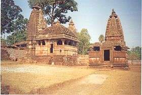
The ancient temples of Kalachuri period are in the south of Narmadakund, just behind it.[6]These were built by Kalachuri Maharaja Karnadeva (1041–1073 AD.)[7]
Flora and fauna
The town of Amarkantak is surrounded by a rich variety of flora with medicinal properties.[8] The Achanakmar Wildlife Sanctuary, is located at a distance of no more than 40 km from the town of Amarkantak in the state of Chhattisgarh on the road to Bilaspur.[9] The enchanting lush green forest belt in Amarkantak is a part of Achanakmar-Amarkantak Biosphere Reserve. The forests of Amarkantak are linked with the forests of Kanha National Park. Amarkantak falls on the Kanha-Achanakmar Corridor, a hilly region covered with dense forests. Kanha and Achanakmar are both conserved wildlife parks in India famous for Bengal tigers.[10]
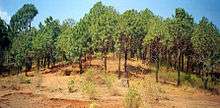
Pinus caribaea, known as tropical pine, was planted in Amarkntak in 1968 on advice of Forest Research Institute, Dehradun on the recommendations of National Commission on Agriculture looking to the future demand of quality pulp wood. This work was undertaken under a World Bank Technical Assistance Project by clearing natural sal forests. The naturalists and environmentalists in India raised a controversy over it; ultimately the project of tropical pine plantation was abolished.[11]
Educational institutions
The Indira Gandhi National Tribal University was established in Amarkantak by an act of parliament[12] in 2007, to promote education and research in various aspects of tribal communities and provide higher education to the tribal population. It has 28 departments which offer undergraduate, post-graduation, and Ph.D. programs.
The Jawahar Navodaya Vidyalaya was established here with the aim of nourishing and fostering the rural young, Jawahar Navodya Vidyalaya, Anuppur started in the year 1987.[13]
References
- ↑ "Kabir Chabutra". C.P.R. Environmental Education Centre.
- ↑ Bhattacharyya, P.K. (1977), Historical Geography of Madhya Pradesh from Earlier Records, Motilal Banarsidass, p. 76
- ↑ http://www.spicejet.com/newspage.aspx?strNews=Flights_Jabalpur
- ↑ "Amarkantak PinCode". citypincode.in. Retrieved 2014-03-10.
- ↑ http://www.census2011.co.in/data/town/802421-amarkantak.html
- ↑ Chadhar, Mohanlal (2017), Amarakantak kshetra ka puravaibhava, SSDN, Publisher and Distributor, New Delhi, ISBN 978-93-8357-509-1
- ↑ Mitra, Swati (2012), Templesof Madhya Pradesh - Travel guide, Thomson Press, New Delhi on behalf of Eicher Goodreads Pvt Ltd, p. 89
- ↑ "Medicinal Plants of Amarkantak". academia.edu.
- ↑ "The Hindu".
- ↑ "Kanha-Achanakmar". The Hindu.
- ↑ Yugdharm, Raipur, Forest Wealth Special Issue, 1979
- ↑ http://igntu.nic.in/act.pdf
- ↑ http://www.jnvamk.in/aboutus.html
External links
| Wikimedia Commons has media related to Amarkantak. |