Nappanee Eastside Historic District
|
Nappanee Eastside Historic District | |
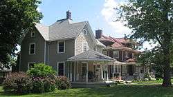 Berlin and Coppes Houses, Nappanee.jpg | |
  | |
| Location | Roughly bounded by Market, Main, John and Summit Sts., Nappanee, Indiana |
|---|---|
| Coordinates | 41°26′39″N 85°59′52″W / 41.44417°N 85.99778°WCoordinates: 41°26′39″N 85°59′52″W / 41.44417°N 85.99778°W |
| Area | 55 acres (22 ha) |
| Architect | Frazier, Henry F and Clarence Elbert; Turnock, E Hill |
| Architectural style | Late Victorian, Late 19th And 20th Century Revivals, Prairie School |
| NRHP reference # | 03001321[1] |
| Added to NRHP | December 23, 2003 |
Nappanee Eastside Historic District is a national historic district located at Nappanee, Elkhart County, Indiana. The district encompasses 138 contributing buildings in a predominantly residential section of Nappanee. It was developed between about 1880 and 1940, and includes notable examples of Italianate, Queen Anne, Colonial Revival, and Prairie School style architecture. Located in the district are the separately listed Frank and Katharine Coppes House and Arthur Miller House.[2]
It was added to the National Register of Historic Places in 2003.[1]
References
- 1 2 National Park Service (2010-07-09). "National Register Information System". National Register of Historic Places. National Park Service.
- ↑ "Indiana State Historic Architectural and Archaeological Research Database (SHAARD)" (Searchable database). Department of Natural Resources, Division of Historic Preservation and Archaeology. Retrieved 2015-10-01. Note: This includes Christopher Baas (March 2003). "National Register of Historic Places Inventory Nomination Form: Nappanee Eastside Historic District" (PDF). Retrieved 2015-10-01. and Accompanying photographs and map.


This article is issued from
Wikipedia.
The text is licensed under Creative Commons - Attribution - Sharealike.
Additional terms may apply for the media files.