Napa State Hospital
| Napa State Hospital | |
|---|---|
| California Department of State Hospitals | |
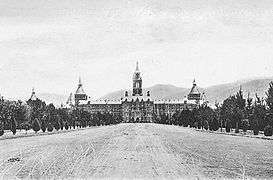 Original Kirkbride building, c. 1900 (destroyed in 1906 earthquake) | |
| Geography | |
| Location | Napa, Napa Valley, Napa County, California, U.S. |
| Services | |
| History | |
| Founded | 1875 |
| Links | |
| Website | http://www.dsh.ca.gov/Napa/ |
| Lists | Hospitals in U.S. |
Napa State Hospital is a psychiatric hospital in Napa, California, founded in 1875. It is located along California State Route 221, also known as the Napa Vallejo Highway. One of California's five state hospitals, Napa State holds civil and forensic patients in a sprawling 138 acre campus. According to a hospital spokesperson, there were 2,338 people employed at the facility during the 2016-2017 fiscal year, making it one of the region's largest employers.
The Napa Valley Cricket Club play their matches at McGrath Field, a multi-use sports field, at the eastern end of the Napa State Hospital campus.
History
Originally named Napa Insane Asylum, the facility opened on November 15, 1875. It sat on 192 acres (0.8 km2) of property stretching from the Napa River to what is now Skyline Park. The property was originally part of Rancho Tulucay, part of a Mexican Land Grant, sold by Cayetano Juarez to the State of California in 1872. The facility was originally built to relieve overcrowding at Stockton Asylum. By the early 1890s the facility had over 1,300 patients which was over double the original capacity it was designed to house. The original main building known as "The Castle" was an ornate and imposing building constructed with bricks. Facilities on the property included a large farm that included dairy and poultry ranches, vegetable garden and fruit orchards that provided a large part of the food supply consumed by the residents. [1]
Notable patients
References
- ↑ Kirkpatrick, Kirk (February 20, 2018). "Once upon a time, a hospital castle was Napa Valley's centerpiece". Napa Valley Register. Napa, CA: Lee Enterprises, Inc. Retrieved February 21, 2018.
- ↑ Frank Shyong (20 August 2016). "Cal State Fullerton killer's hospital transfer sparks protests from his victims' families". Los Angeles Times.
- ↑ "Thorpe pleads guilty to murder". The Union. Nevada County, California. March 21, 2003.
External links
| Wikimedia Commons has media related to Napa State Hospital. |
- Napa State Hospital website
- This hospital in the CA Healthcare Atlas — project by OSHPD.
- Doctor Vista.com: Napa State Hospital profile
- Arcadiapublishing.com: Napa State Hospital - book by Arcadia Publishing.
Coordinates: 38°16′42″N 122°16′26″W / 38.278233°N 122.273771°W