Naco, Arizona
| Naco, Arizona | |
|---|---|
| CDP | |
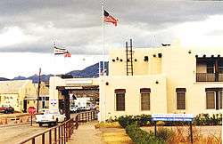 US Customhouse at Naco, Arizona | |
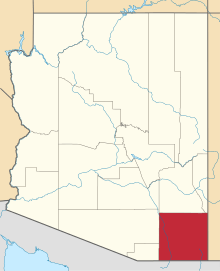
 Location of Naco, Arizona | |
 Naco, Arizona Location in the United States | |
| Coordinates: 31°20′14″N 109°56′40″W / 31.33722°N 109.94444°WCoordinates: 31°20′14″N 109°56′40″W / 31.33722°N 109.94444°W | |
| Country | United States |
| State | Arizona |
| County | Cochise |
| Area[1] | |
| • Total | 3.30 sq mi (8.55 km2) |
| • Land | 3.30 sq mi (8.55 km2) |
| • Water | 0.00 sq mi (0.00 km2) |
| Elevation | 4,610 ft (1,405 m) |
| Population (2000) | |
| • Total | 13,694 |
| • Estimate (2016)[2] | N/A |
| Time zone | UTC-7 (Mountain (MST)) |
| ZIP code | 85620 |
| Area code | 520 |
| FIPS code | 04-48310 |
| GNIS feature ID | 0008475 |
Naco, a Census-Designated Place (CDP) located in Cochise County, Arizona, United States had a recorded population of 1,046 during the 2010 census. It's located directly across the United States–Mexico border from its sister city Naco, Sonora. Naco is best known for an accidental 1929 air raid, is the first and only municipality in the Continental United States to have been aerially bombed by foreigners. [3]
The present-day unincorporated town of Naco, Arizona, was established in the early 20th century. The area was originally settled by the Nahua and Opata Indians. Naco means "nopal cactus" in the Opata language. The U.S. Congress officially established Naco as a Port of Entry on June 28, 1902.[4] Today, the Naco port of entry is open 24 hours per day.
1929 Air Raid
The accidental 1929 Bombing of Naco by Irish-American mercenary Patrick Murphy is notable for being the first and only instance where a town in the Continental United States was bombed by aircraft working for a foreign Power.[3] The 1942 Lookout Air Raids, when a Japanese floatplane pilot made two unsuccessful attempts to start forest fires in rural Oregon, and the 1944-45 unmanned Fu-Go Fire balloon attacks, also by the Japanese, are the only other cases of the Continental United States enduring aerial bombing by a foreign power. Such events are exceptionally rare in American history because during 20th century conflicts, most notably World War I and World War II, the continental United States escaped the large-scale aerial bombings that devastated many Asian and European cities.
The background to the bombing of Naco started in early 1929, when José Gonzalo Escobar led a rebellion against the government of Emilio Portes Gil. Mexican federal troops dug in around Naco, Sonora (which bordered Naco, Arizona) and were almost under constant attack by the rebels. The battles became something of a spectator sport on the Arizona side of the border with people coming from as far as Bisbee to watch. While the occasional stray bullet would send these spectators towards cover, both sides in the conflict were careful as they did not want U.S. Armed Forces coming across the border to retaliate.[5]
Patrick Murphy was an aviator who owned his own bi-winged airplane and performed tricks with it. Murphy decided to help the rebels by offering to build homemade bombs and drop them on federal positions. His offer was accepted by the rebels, who promised a reward. The bombs were made by filling pipes with dynamite, scrap iron, nails and bolts then putting the pipes in old leather suitcases. Murphy made two attempts on 31 March and 1 April but the bombs failed to explode. A third bomb hit the customs house, spraying spectators on the Arizona side of the border. Murphy made four more bombs which were dropped between 4 and 6 April. The first hit a trench, killing two federal soldiers, but the other three inadvertently landed on the Arizona side of the border, hitting various buildings in Naco, Arizona. The next day, U.S. government troops arrived and disabled Murphy’s plane. Murphy escaped to Mexican rebel lines and crossed back to the U.S. when the rebellion ended, and was briefly jailed for his violation of neutrality laws. Murphy was the first person working for a foreign entity to bomb U.S. soil.[6][5]
Geography
Naco is located at 31°20′14″N 109°56′40″W / 31.33722°N 109.94444°W (31.337287, −109.944461).[7] According to the United States Census Bureau, the CDP has a total area of 3.4 square miles (8.8 km2), all of it land.
Attractions
Naco is home to Turquoise Valley, the oldest continuously operated golf course in Arizona—the first to reach 100 continuous years of age.[8]
Demographics
| Historical population | |||
|---|---|---|---|
| Census | Pop. | %± | |
| U.S. Decennial Census[9] | |||
As of the U.S. 2010 census,[10] there were 1046 people, 334 households, and 284 families residing in the CDP. The population density was 307.6 people per square mile (120.2/km²). The racial makeup of the CDP was 62.8% White, 0.67% Native American, 33.7% from other races, and 2.88% from two or more races. 83.9% of the population were Hispanic or Latino of any race.
There were 334 households out of which 146 had children under the age of 18 living with them.
In the CDP, the age distribution of the population shows 40.5% under the age of 18, 5.9% from 18 to 24, 11% from 25 to 34, 15.8% from 35 to 49, 15% from 50-64, and 11.7% who were 65 years of age or older. The population of Naco, by 2010 census estimates, is 48.7% male, 51.3% female.
According to the 2000 census, the median income for a household in the CDP was $22,045, and the median income for a family was $25,227. Males had a median income of $21,923 versus $15,882 for females. The per capita income for the CDP was $9,169. About 33.0% of families and 34.2% of the population were below the poverty line, including 46.1% of those under age 18 and 25.4% of those age 65 or over.
Prehistoric Naco
The Naco-Mammoth Kill Site is located near Naco. Excavations from this archeological site in the 1950s revealed mammoth bones with embedded Clovis points, providing evidence of the hunting activities of Paleo-Indians some 13,000 years ago.[11]
Fort Naco

Fort Naco is a former military post on the outskirts of Naco. Subsequent to Pancho Villa's raid on Columbus, New Mexico, in 1916, Fort Naco was a staging area for American troops protecting the border. It was the headquarters of the 1st Infantry Regiment of the Arizona National Guard.[12]
See also
- Bombing of Naco – the first ever aerial bombardment of the contiguous United States by a foreign power
References
- ↑ "2016 U.S. Gazetteer Files". United States Census Bureau. Retrieved Jul 18, 2017.
- ↑ "Population and Housing Unit Estimates". Retrieved June 9, 2017.
- 1 2 Price, Ethel Jackson (2003). Sierra Vista: Young City with a Past. Arcadia. ISBN 0738524344.
- ↑ "The Naco, Arizona Port of Entry: Archaeology on the Border". U.S. National Park Service. Retrieved 4 November 2012.
- 1 2
- ↑ "U.S.-Mexico Border". National Geographic. May 2007.
- ↑ "US Gazetteer files: 2010, 2000, and 1990". United States Census Bureau. 2011-02-12. Retrieved 2011-04-23.
- ↑
- ↑ "Census of Population and Housing". Census.gov. Retrieved June 4, 2016.
- ↑ "American FactFinder". United States Census Bureau. Archived from the original on 2013-09-11. Retrieved 2008-01-31.
- ↑ Barbara Grijalva. Arizona ice age: Man vs. mammoth. KOLD News. Posted: Apr 19, 2010. Kold.com. Retrieved on 2011-05-27.
- ↑ Camp Naco preservation at the Library of Congress Web Archives (archived 2007-12-13)
External links
- Naco history and prehistory, by National Park Service (English & Spanish)