Nærøyfjord
| UNESCO World Heritage site | |
|---|---|
 Nærøyfjord | |
| Official name | Nærøyfjord Area |
| Location | Aurland, Norway |
| Part of | West Norwegian Fjords – Geirangerfjord and Nærøyfjord |
| Criteria | Natural: (vii)(viii) |
| Reference | 1195-002 |
| Inscription | 2005 (29th Session) |
| Area | 51,802 ha (128,010 acres) |
| Coordinates | 60°56′37″N 6°55′53″E / 60.94361°N 6.93139°ECoordinates: 60°56′37″N 6°55′53″E / 60.94361°N 6.93139°E |
 Location of Nærøyfjord in Norway | |
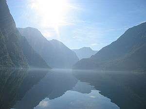
The Nærøyfjord (or Nærøyfjorden) is a fjord in the municipality of Aurland in Sogn og Fjordane, Norway. The narrow fjord is a branch of the large Sognefjord, and it is featured on the "Norway in a Nutshell" daytrips for tourists. The 18-kilometre (11 mi) long fjord is only 500 metres (1,600 ft) wide in some parts.[1]
The river Nærøydalselvi flows down the valley Nærøydalen into the fjord at the village of Gudvangen, near the highway E16. The village of Bakka and the Bakka church are located on the west shore of the fjord.
Since 2005, the Nærøyfjord has been listed as a UNESCO World Heritage Site. It has also been rated by the National Geographic Society as the world's number one natural heritage site along with the Geirangerfjord.
In popular culture
Nærøyfjord was also used as an inspiration for Arendelle in Frozen.[2]
Media gallery
 Nærøyfjord with sightseeing boat
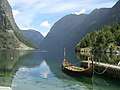 View from Gudvangen
 Gudvangen ferry
 Nærøyfjord
.jpg) Nærøyfjord
Nærøyfjord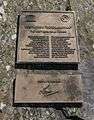 Plaquette at Bakka, signed by Queen Sonja of Norway June 10, 2006.
References
- ↑ Store norske leksikon. "Nærøyfjorden" (in Norwegian). Retrieved 2010-09-05.
- ↑ "Disney's Frozen: Inspired by Norway's beauty". Retrieved 18 January 2014.
External links

- Nærøyfjord Website
- Official tourist information
| Northern |
| |
|---|---|---|
| Trøndelag |
| |
| Western |
| |
| Eastern | ||
1 Shared with nine other countries | ||