Bakka, Sogn og Fjordane
| Bakka | |
|---|---|
| Village | |
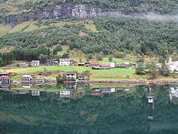 View from the fjord | |
 Bakka Location in Sogn og Fjordane county  Bakka Bakka (Norway) | |
| Coordinates: 60°54′58″N 06°52′08″E / 60.91611°N 6.86889°ECoordinates: 60°54′58″N 06°52′08″E / 60.91611°N 6.86889°E | |
| Country | Norway |
| Region | Western Norway |
| County | Sogn og Fjordane |
| District | Sogn |
| Municipality | Aurland |
| Elevation[1] | 29 m (95 ft) |
| Time zone | UTC+01:00 (CET) |
| • Summer (DST) | UTC+02:00 (CEST) |
| Post Code | 5749 Bakka |
Bakka is a tiny village in the municipality of Aurland in Sogn og Fjordane county, Norway. It is located on the western shore of the Nærøyfjord, about 5 kilometres (3.1 mi) north of the village of Gudvangen and access to the European route E16 highway. The village is home to the Bakka Church. In 2000, the 1.7-kilometre (1.1 mi) Bakka Tunnel was constructed on the road from Gudvangen to Bakka to make the journey quicker and safer.
Name
The name Bakka is derived from the Old Norse word bakki which means "hill". The -a ending is the dative case ending used with prepositions to show location: "on the hill". In the 19th century, it was common to spell the name Bakke.[2][3]
Media gallery
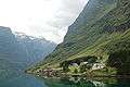 View of Bakka
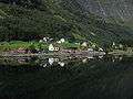 Bakka
Bakka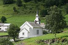 Bakka Church
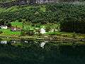 Village and church
References
- ↑ "Bakka" (in Norwegian). yr.no. Retrieved 5 September 2010.
- ↑ Brekke, Arne. "The Farm Names in Bakka and Nærøyfjord". Archived from the original on 18 July 2011. Retrieved 29 June 2008.
- ↑ Rygh, Oluf (1919). Norske gaardnavne: Nordre Bergenhus amt (in Norwegian) (12 ed.). Kristiania, Norge: W. C. Fabritius & sønners bogtrikkeri. p. 122.
This article is issued from
Wikipedia.
The text is licensed under Creative Commons - Attribution - Sharealike.
Additional terms may apply for the media files.