Mwanga District
| Mwanga District | |
|---|---|
| District | |
 | |
| Country | Tanzania |
| Region | Kilimanjaro Region |
| Population (2012) | |
| • Total | 131,442 |
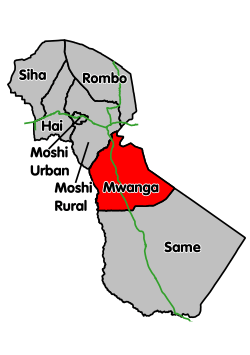
Mwanga is one of the seven districts of the Kilimanjaro Region of Tanzania. It is bordered to the northeast by Kenya, to the northwest by the Moshi Rural District, to the southwest by the Manyara Region, and to the south by the Same District. Its administrative seat is the town of Mwanga.
According to the 2002 Tanzania National Census, the population of the Mwanga District was 115,145.
According to the 2012 Tanzania National Census, the population of Mwanga District was 131,442.[1]
Wards
The Mwanga District is administratively divided into 16 wards:
Sources
See also
References
- ↑ "Census 2012". National Bureau of Statistics. Archived from the original on 5 March 2016. Retrieved 20 April 2016.
Coordinates: 3°45′S 37°40′E / 3.750°S 37.667°E
This article is issued from
Wikipedia.
The text is licensed under Creative Commons - Attribution - Sharealike.
Additional terms may apply for the media files.