Muqeem Shah
| Hujra Shah Muqeem, Khyber-Pakhtunkhwa | |
|---|---|
| Town and union council | |
 Khyber-Pakhtunkhwa | |
| Country | Pakistan |
| Province | Khyber-Pakhtunkhwa |
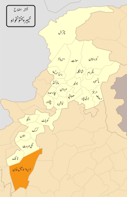
| District | Dera Ismail Khan District |
| Time zone | UTC+5 (PST) |
Muqeem Shah (( مقیم شاہ or Muqeem Shah, Khyber-Pakhtunkhwa is a town a in the Dera Ismail Khan District of the Khyber-Pakhtunkhwa province in Pakistan.[1]
Geography
The town is situated in north of District D.I. Khan, at a distance of 25 km across Bannu road, the town has a link road from Bannu road at place named Muqeem Shah Adda. The town comes in Union Council Kech. The neighbourhood villages are Kech, Hissam, Pusha, Girsal. The town Muqeem Shah is located at centre of the cited Union Council. It lies at an altitude of 188 metres (620 feet).[2]
Name
The town is named after Syed Peer Muqeem Shah, who is buried there. He belonged to the Sherazi family that later migrated to Dera Ismail Khan, a town situated in the Dera Ismail Khan District in the south of Khyber-Pakhtunkhwa.
History
There is no one having a complete history about the foundation of town, but some clues show that the town is very old. Some graves in the town's graveyard are at least two or three hundard years old. The data about Syed Peer Muqeem Shah is also not available in solid shape, there are just unreliable stories about him: Some say, he had been migrated from Sindh, some relate him to Hujra Shah Muqeem, some say, his brother is buried in Sargodha.
Population
The population of the town is of about 300 houses. The population is now increasing because being a peace full place people are migrating here day by day.
Laguanges
The majority of the inhabitants are Saraiki speakers, but some tribes and Afghan refugees, who speak Pashto, also dwell in the surrounding of village.
Professions
The villagers profession is agriculture i.e. they are cultivators and they work on daily wages in different fields (labour). A few people have government jobs in police, army and education departments.
Clans
The local clans are Kanju clan, Dhudi and Khakhi, Gurya. The most educated clan is Kanju. The educated family of this clan is AurangZeb Khan's family, whose three members Mujahid Iqbal Kanju, Javed Iqbal and Asif Iqbal got higher education. The Kanju family is an influential family of the area. The malik of the town also belongs to the Kanju clan. He is called Malik Ilahi Bakhsh Kanju and is the landlord of the town.
Schools and education
The town has a primary school, a middle school for boys and a primary school for girls. The education rate is very low. Therefore, an educational environment needs to be developed in the town.
Notable Persons
The following personalities belong to the town:
- Malik Rabnawaz Kanju, (Late) Ex-Councillor
- Malik Shabeer Kanju, Social Worker
- Malik Illahi Bakhsh Kanju, Ex-councillor
- Syed Peer Muzamil Shah Shirazi, Social Worker
- Aurangzeb Khan, Educationist
- Muhammad Ramzan Kanju Serving in Pak Army
Religion
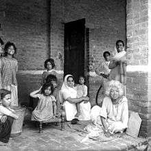
After the independence of Pakistan in 1947, the minority Hindus and Sikhs migrated to India. In 1947 several families from Dera Ismail Khan left the area and settled as refugees in the Kingsway Camp in North Delhi.
The town's inhabitants are now mainly Muslim, followers of Sunni Sect. They respect all other sects. They never support any type sectarianism.
Crops
Wheat, rice, sugarcane, gram, barly, maze, great-millet, oat, millet, buck-wheat, paddy, mustard, field pea, sugar beat, tomatoes, mint, onion are the popular crops cultivated here.
Sports
The people love to play their traditional games like tuod, khushti, kabadi, rasa kashi. But the young generation likes to play cricket, volleyball and football. As there is no proper playground, these games are played in open fields surrounding the town during the cutting season of crops.
Note
Most of the information in this article is given by Mujahid Iqbal Kanju and also help is taken from the references shown below.